.jpg)
Cosumnes River Preserve: The Last Free-Flowing River
Every river in California's Central Valley has been dammed -- every river except one. The Cosumnes flows roughly 52 miles from the Sierra Nevada foothills to the Sacramento-San Joaquin Delta without a single major dam interrupting its course. When heavy rains come, the river floods. Sediment spreads across the floodplain. Valley oaks sink roots 80 feet into the saturated earth. Sandhill cranes drop out of the sky by the thousands, following the Pacific Flyway to wetlands that exist because no one built a wall of concrete across this particular stretch of water. The Cosumnes River Preserve -- over 51,000 acres of oak savanna, riparian forest, wetland, and working farmland 20 miles south of Sacramento -- protects what remains of a landscape that once covered the entire valley floor.
The Miwok and the River They Shaped
The Miwok people lived along the Cosumnes for centuries, shaping the land with fire and intention. They burned underbrush to encourage the growth of food plants, managed floodplains to improve fish habitat, and built a diet around acorns, seeds, deer, and the river's salmon runs. By a 1770 estimate, roughly 9,000 Miwok lived in the region, organized into 28 small groups of 300 to 475 people -- a population density of about 10 persons per square mile, possibly the highest of any California tribe. Their management was sophisticated enough that fish populations likely benefited. The arrival of Spanish explorers in the mid-1700s began the unraveling. John Sutter colonized the area in the 1840s; the Gold Rush brought miners who dammed the river and plowed under the oak groves. Miwok villages and burial grounds were destroyed. By 1999, the last speaker of Plains Miwuk had died.
The Swamp Oaks
The valley oak is the largest native oak in California, capable of living 600 years and sending a vertical root system 80 feet down to reach groundwater. It once formed vast groves along the Central Valley's rivers and open savannas across its grasslands. By the 1980s, those groves were vanishing -- cleared for farmland and swallowed by urban sprawl from Sacramento and Stockton. The Nature Conservancy surveyed the entire valley and found the best remaining stands along the lower Cosumnes. In 1987, they established an 800-acre preserve. But scientists soon realized the oaks could not be saved in isolation. The valley oak thrives on deep alluvial soil deposited by seasonal flooding -- the same rich earth that makes excellent farmland. Saving the tree meant saving the river's natural flood cycles, which meant thinking on the scale of an entire watershed. By 1993, the Conservancy had expanded its approach from land purchases to cooperative agreements with farmers, water agencies, and federal and state land managers, aiming to protect a watershed of 1,200 square miles.
Letting the River Be a River
The science behind the Cosumnes River Preserve inverts the usual logic of conservation. Instead of building infrastructure to manage nature, the preserve tears infrastructure down. Levees have been deliberately breached to allow floodwaters to spread across the floodplain. The results have been striking: seasonal flooding scours out invasive non-native grasses, reduces populations of gophers that feed on acorn seedlings, and deposits the sediment that cottonwoods and willows need to establish. Those new trees trap more sediment during the next flood, accelerating the restoration. Ecologist Rich Reiner calls it "natural process restoration" -- letting the river do the work that engineers had been trying to replicate with machinery. The approach has broader implications for water management throughout the Central Valley, where every other river is held behind dams that eliminate the flood pulses essential to floodplain ecosystems.
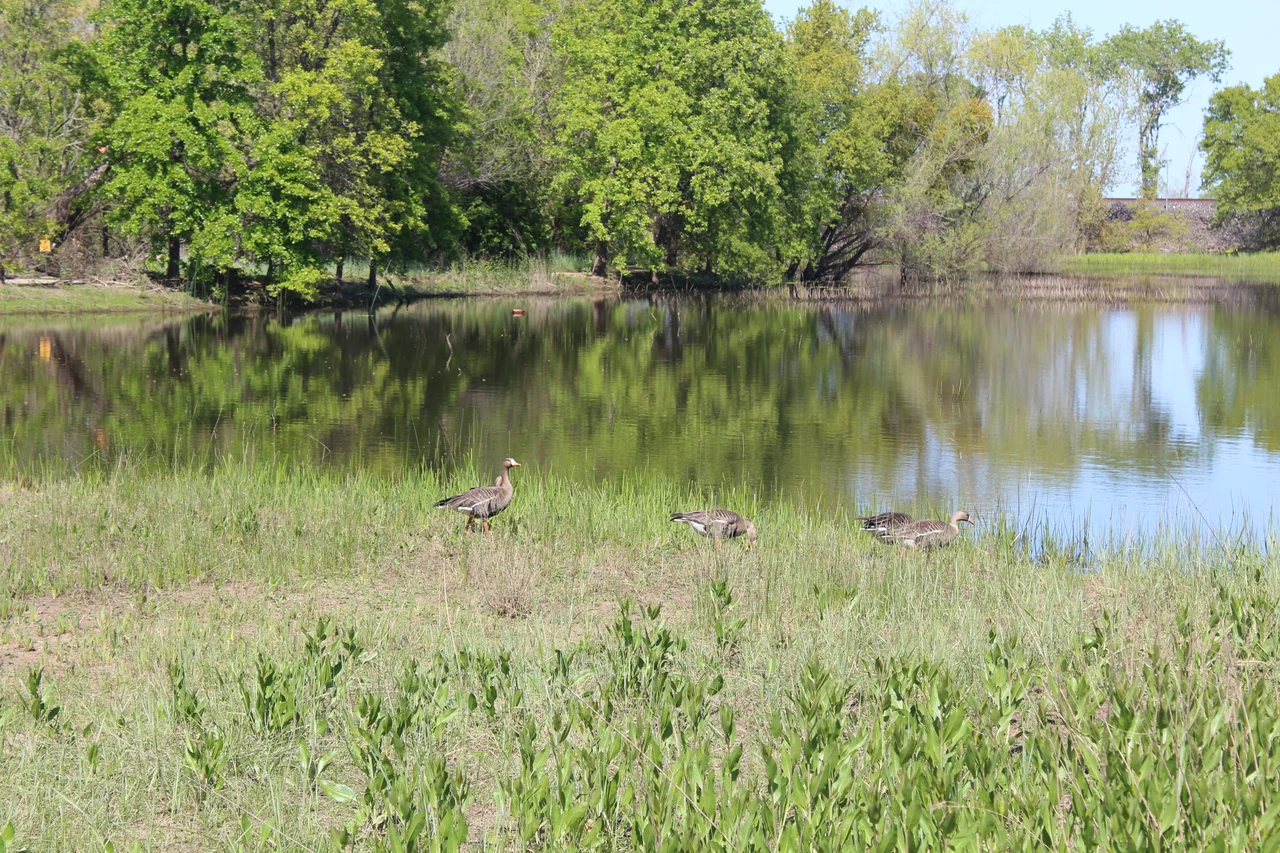
Wings on the Flyway
More than 250 bird species have been recorded at the Cosumnes River Preserve, placing it firmly on the map of the Pacific Flyway -- the migration corridor stretching from Alaska to Patagonia. Each fall, greater and lesser sandhill cranes arrive by the thousands, their prehistoric calls carrying across the wetlands at dawn. Tundra swans, white-fronted geese, and dozens of duck species follow. The preserve is designated an Important Bird Area by both the American Bird Conservancy and the National Audubon Society. Rare residents include the tricolored blackbird and the Swainson's hawk. The California giant garter snake and the elderberry longhorn beetle -- both threatened species -- find habitat here. Chinook salmon still run the Cosumnes, navigating the undammed river to reach spawning grounds. At sunset, visitors on the preserve's bat paddle witness tens of thousands of Mexican free-tailed bats pouring from roosts to feed above the water, close enough to feel the air displaced by their wings.
Squeezed Between Cities
The Cosumnes River Preserve sits in a geographic vise. Sacramento presses from the north; Stockton pushes from the south. Urban growth threatens to reduce the protected corridor to a narrow band between the Sierra foothills and the Delta. The preserve's response has been to grow strategically. In 1998, the Conservancy purchased the 13,000-acre Howard Ranch -- with its vernal pools and sweeping views of the Sierra -- using grants and federal Clean Water Act funds, the first time those funds had been used to buy and protect wetlands. Today the preserve encompasses over 51,000 acres managed by a coalition including the Bureau of Land Management, California Department of Fish and Wildlife, Ducks Unlimited, and private landowners. Nearly 40,000 acres remain in agricultural production, a deliberate choice: working farms buffer the wildest areas and keep the land from being sold for development. Conservation and agriculture coexist here -- and sometimes must.
From the Air
Located at approximately 38.27°N, 121.44°W, about 20 miles south of Sacramento in the Central Valley. The preserve is visible from altitude as a band of green -- oak woodland and wetland -- cutting through the agricultural patchwork between Sacramento and Stockton. The Cosumnes River meanders through the landscape without the telltale blue rectangles of reservoirs that mark every other Central Valley river. Wood Duck Slough and the Tall Forest are visible as dense canopy along the waterway. Nearby airports include Sacramento Executive Airport (KSAC) to the north and Stockton Metropolitan Airport (KSCK) to the south. Best viewed at 2,000-4,000 feet AGL during fall and winter when flooded fields reflect sky and cranes are visible in large flocks.
Nearby Stories
- Eight Hours at the Good Guys 2.9 km away
- Joint Genome Institute 4.9 km away
- Where Salt and Fresh Water Negotiate 8.1 km away
- The Glory Hole: Monticello Dam and the Drain That Swallows a Lake 10 km away
- Gold Country 22 km away
- Altamont Free Concert 27 km away
- From Aluminum to Ammunition to Aviation Fuel 28 km away
- Sutter's Mill 34 km away