The Glory Hole: Monticello Dam and the Drain That Swallows a Lake
From above, it looks like someone pulled a plug in the middle of a lake. A perfect circle of water spiraling downward into darkness, 72 feet across, swallowing everything the surface sends its way. The Glory Hole at Monticello Dam is not the largest spillway in the world, nor the most powerful. But it may be the most mesmerizing. When Lake Berryessa fills to capacity after heavy rains, the morning-glory spillway activates, and water pours over the circular lip in a smooth, terrifying funnel that drops 200 feet through the dam's interior before emerging below. Videos of the phenomenon have drawn millions of views online. The engineering is elegant. The visual is unnerving. And beneath this lake lies a town that was sacrificed to make it all possible.
Engineering a Valley's Fate
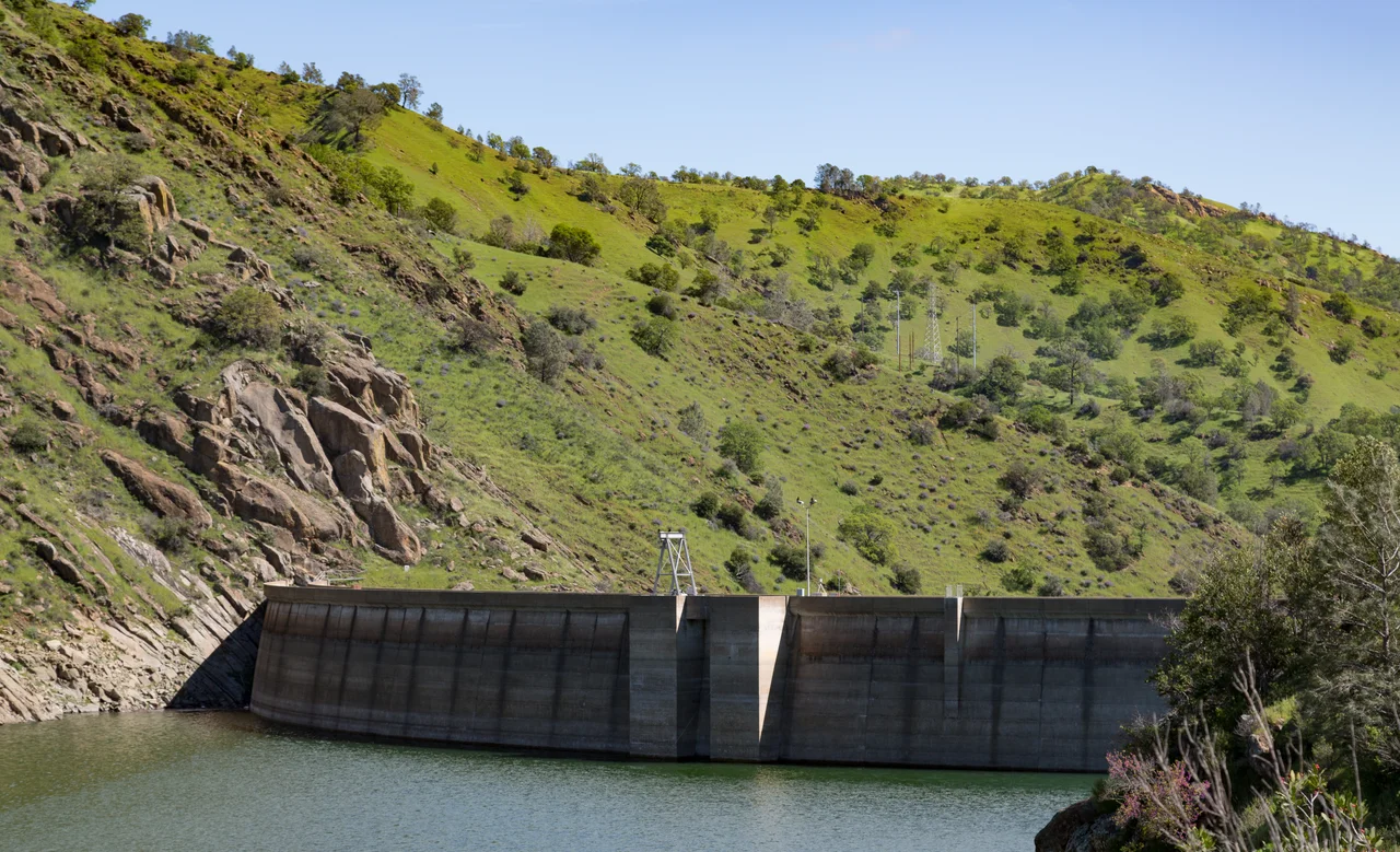
The Solano Project took shape in the 1940s, when the Solano Irrigation District organized to manage the water resources of Putah Creek. On November 11, 1948, the Secretary of the Interior formally authorized construction. The Bureau of Reclamation built the dam between 1953 and 1957 - a 304-foot concrete arch spanning the narrow canyon where Putah Creek flowed through the Vaca Mountains. The result was Lake Berryessa, California's seventh-largest man-made lake, holding 1.6 million acre-feet of water across 20,700 surface acres. A powerplant completed in 1983 added three generators producing 11.5 megawatts, sending electricity to the North Bay. The dam's primary mission, though, has always been irrigation: the 33-mile Putah South Canal distributes water to farms throughout Solano County, and a 1999 contract provides for delivery of 207,350 acre-feet annually.
The Town They Drowned
Building the dam meant killing a community. The inhabitants of Berryessa Valley vehemently opposed the project. Even the city of Winters, which stood to benefit from the new water supply, fought against it because of close social ties to the town of Monticello. Opposition changed nothing. Land purchases began in 1953, though residents were allowed to remain until rising water actually reached their property. Most of Monticello's people left by summer 1956. Crews then moved through the valley, cutting down trees, demolishing homes, tearing out infrastructure. About 300 graves had to be relocated to higher ground. Photographer Dorothea Lange documented the town's final days for what she intended as a Life magazine feature. The magazine never published it, but the images survived - a record of what progress costs when progress needs your valley.
The Hypnotic Drain
The Glory Hole is an uncontrolled morning-glory-type spillway, meaning it operates passively whenever the lake reaches its maximum elevation of 440 feet. Water simply flows over the circular concrete lip, spiraling downward through a vertical shaft and then through a horizontal tunnel that exits below the dam. For years at a time, the spillway sits dry and exposed, its concrete funnel gaping at the sky like an empty eye socket. Then the rains come. In February 2017, after storms raised the lake level 35.5 inches in six weeks, boaters grew so eager to witness the spillway's activation that they generated enough wake to push water over the rim prematurely at 1:45 p.m. on February 13. The official spill began three days later, on February 16, for the first time in over a decade. It spilled again in February 2019.
The Danger Below the Surface
Swimming near the Glory Hole is prohibited, and the prohibition exists for the most direct of reasons. In 1997, Emily Schwalen of Davis was swimming near the spillway when she was caught in the current. She managed to hold onto the concrete rim for approximately twenty minutes before the water pulled her over the edge and down the pipe. She did not survive. It remains the only known death from the spillway drain, but one death was enough to cement the Glory Hole's reputation as something more than a curiosity. The smooth, almost gentle appearance of the water flowing over the lip conceals enormous hydraulic force. Warning buoys mark the exclusion zone, and signs are explicit. The spectacle is best appreciated from shore.
A Lake's Troubled Second Act
Lake Berryessa once drew 1.3 million visitors annually. That number has dropped below 400,000, a decline driven not by the lake's appeal but by bureaucratic mismanagement. In 2008, the Bureau of Reclamation attempted to install a new concessionaire, Pensus Inc., to operate the resorts around the lake. The transition failed badly. Local resort operators were forced out without proper compensation, and the Bureau demolished their facilities. The economic collapse rippled through the surrounding community. Meanwhile, the dam itself continues doing what it was built to do: the reservoir has prevented an estimated $5 million in flood damages since 1957, and the water keeps flowing to Solano County's farms. The environmental costs are measured differently - reduced groundwater recharge, deteriorated sandbars, and declining cottonwood and willow populations along Lower Putah Creek.
From the Air
Located at 38.51°N, 122.10°W in the Vaca Mountains of Napa County. The dam and Glory Hole spillway are at the southern end of Lake Berryessa, which stretches roughly 15 miles northward through the valley. From altitude, the lake is unmistakable - a large blue reservoir filling a mountain valley. The Glory Hole appears as a dark circle near the dam when the lake is below spillway level. The closest airports are Napa County Airport (KAPC) about 18 miles west-southwest and Nut Tree Airport (KVCB) about 12 miles south-southeast. Terrain rises to 2,000+ feet on either side of the lake in the Vaca Mountains. Best viewed at moderate altitude; the dam structure and spillway are visible in clear conditions.
Nearby Stories
- Yolo Causeway 2.3 km away
- Eight Acres for a Plant That Exists Almost Nowhere 2.9 km away
- The Stone Chapel That Survived Everything 9 km away
- Where Carlin Took His Last Bow 11 km away
- Locke: The Town They Built But Could Not Own 14 km away
- Rico Harris 14 km away
- The Fence That Ran to the Sea 20 km away
- Sutter Hock Farm 22 km away