Yolo Causeway
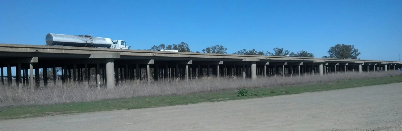
The trophy is a cylinder of concrete, cored from the bridge itself. Every November, the UC Davis Aggies and the Sacramento State Hornets play the Causeway Classic, and the winner takes home this unglamorous chunk of infrastructure as proof of victory. It is a fitting prize. The Yolo Causeway is not a beautiful bridge. It is a utilitarian elevated highway on Interstate 80, a pair of twinned concrete trestles carrying six lanes of traffic across a floodplain between West Sacramento and Davis. But it is a bridge with layers: a successor to ferry crossings and plank roads, a former segment of the Lincoln Highway, a memorial to two murdered officers, and, improbably, the summer home of a quarter-million bats.
Ferries, Plank Roads, and Tule Jake
Before there was a causeway, there was mud. The Yolo Bypass basin flooded every winter, and for much of the 1800s, ferry service was the only way across. The first county seat of Yolo County, a town called Fremont built near the ferry crossing at the confluence of the Sacramento and Feather Rivers, was wiped out entirely by floods in 1851. Settlers tried alternatives. The Yolo Plankroad, a 4.5-mile timber route, reached toward present-day Woodland. When the ground finally dried each summer, the first vehicle to make it across the basin would establish the seasonal "Tule Jake" Road, passable only in the dry months. The names tell the story: this was country that belonged to the water for half the year and grudgingly yielded to wheels for the other half.
The First Crossing and the Lincoln Highway
The original Yolo Causeway opened on March 18, 1916, connecting West Sacramento with Davis on a permanent, year-round basis for the first time. It was a modest structure, but in 1928 it gained national significance when the completion of the Carquinez Bridge rerouted the Lincoln Highway, the first road across America, through this crossing. Suddenly the Yolo Causeway was a link in the chain that connected New York to San Francisco. The bridge later carried US Highways 40 and 99W, serving as the primary corridor between Sacramento and the Bay Area. For decades, it was simply the way west.
Blecher, Freeman, and the 1978 Shooting
The current causeway was built in 1962, replacing the original with a pair of twinned concrete trestles separated by an earth-fill segment. Traffic reporters sometimes distinguish between the "long bridge" and the "short bridge," each carrying three lanes. In 1994, the structure was renamed the Blecher-Freeman Memorial Causeway in honor of two California Highway Patrol officers, shot to death in 1978 after a highway stop just east of the causeway. The renaming was quiet, passed through an Assembly Concurrent Resolution. Most drivers crossing the bridge have no idea they are traveling over a memorial. The name appears on signs that flash past at 65 miles per hour, a reminder of violence absorbed into the daily commute.
Bat City, Population 250,000
Every June, approximately 250,000 Mexican free-tailed bats migrate to the Yolo Causeway. They roost in the expansion joints between the concrete segments, hanging in dense clusters in the gaps that engineers designed to absorb thermal expansion. At dusk, they stream out in a dark, spiraling column to hunt the insects breeding in the wetlands of the Yolo Bypass below. The spectacle has become a draw: the Yolo Basin Foundation conducts popular bat tours on summer evenings. But the bats are also a complication. In 2018, Caltrans announced plans to widen the causeway to four lanes in each direction, an $800 million project to address one of California's worst freeway bottlenecks. Environmental groups, including the Natural Resources Defense Council and the Sierra Club, sued, citing concerns that construction would disrupt the bat colony, as well as Swainson's hawks and tricolored blackbirds in the surrounding habitat.
Bottleneck, Battleground, Bridge
The proposed widening has turned the causeway into a test case for California's approach to freeway expansion. Under a 2013 amendment to the California Environmental Quality Act, Caltrans must mitigate the environmental impact of additional traffic induced by any project it builds. The agency's own district director acknowledged that fully mitigating this project's impacts is not feasible. Environmental groups argue the environmental impact report underestimates effects on traffic volumes, greenhouse gas emissions, and air quality. The causeway thus embodies a tension that runs through modern California: the need to move people efficiently versus the obligation to protect the ecosystems that have colonized the infrastructure. The bats did not ask for a home in the expansion joints. But they found one, and now they have lawyers.
From the Air
Located at 38.56N, 121.64W, the Yolo Causeway is the distinctive east-west bridge carrying I-80 across the Yolo Bypass floodplain. From the air, the twin trestle structures are clearly visible as elevated roadways crossing the flat wetland basin between West Sacramento and Davis. During winter floods, the causeway appears to hover over water. Sacramento Executive Airport (KSAC) is 7nm east; University Airport Davis (KEDU) is 4nm west. Best viewed at 1,500-2,500 feet AGL. The causeway runs roughly east-west and serves as a reliable visual navigation reference between the Sacramento metro area and Solano/Yolo county farmland.
Nearby Stories
- Cosumnes River Preserve: The Last Free-Flowing River 6.5 km away
- The Warehouse on Oakdale Road 10 km away
- The Stone Chapel That Survived Everything 14 km away
- Four Names, Three Wars, Nine Missiles 18 km away
- Gold Country 24 km away
- Rico Harris 29 km away
- New Melones Dam 55 km away
- Malakoff Diggins State Historic Park 57 km away