.jpg)
The River That Nobody Dammed
The Miwok called it "kosum" -- salmon. Add the suffix "-umne," meaning "people of," and you have the Cosumnes: the river of the salmon people. It is a name that carries both memory and loss, because Chinook salmon are now rarely seen above Rancho Murieta, blocked by diversion dams that do not quite count as the kind of dam that would strip the river of its singular distinction. The Cosumnes remains the only river flowing from the western slope of the Sierra Nevada without a major dam on its main stem. Every other waterway in California's Central Valley -- the American, the Feather, the Stanislaus, the Tuolumne -- has been plugged with concrete. The Cosumnes still floods when it rains.
Three Forks Through Gold Country
The river begins as three branches cutting canyons through El Dorado and Amador County gold country. The North Fork starts at Singleton Springs, 7,400 feet above sea level at the head of Leek Spring Valley, and drops 49 miles westward past the unincorporated community of Meiss, through the granite narrows of the Cosumnes River Gorge -- a popular rock-climbing area where the walls close in tight enough to block the sun -- before turning south to meet the Middle Fork near Enterprise. The Middle Fork runs 44 miles on a parallel course. All three branches converge just east of Highway 49, the road that traces the Mother Lode through the foothills, and from there the Cosumnes becomes a single channel flowing west through an increasingly flat landscape toward the Sacramento-San Joaquin Delta.
Suburbs, Siphons, and Sloughs
West of the foothills, the Cosumnes passes through Rancho Murieta, an affluent outer suburb of Sacramento where two small diversion dams cross the river near Van Vleck Park. These structures, while modest, are enough to block salmon from reaching their historic spawning grounds upstream. Below Rancho Murieta the character of the river changes. It meanders through agricultural flatland, turning southwest near Sloughhouse -- a name that tells you everything about the terrain. The Folsom South Canal crosses beneath the river through an inverted siphon, a piece of engineering that allows the canal's water to pass under the Cosumnes without mixing. Past Sheldon and Wilton, the river picks up Deer Creek, crosses under Highway 99 near Elk Grove, and enters nearly 50,000 acres of preserved wetland and riparian habitat -- one of the largest remaining tracts in the Central Valley.
A Pronunciation Nobody Can Agree On
Ask ten people along the river how to say its name and you will get something close to ten answers. Many locals insert an "n" in the first syllable that does not exist in the spelling: "Con-sumnes." Linguists point out that the same "-umne" suffix appears in Tuolumne and Mokelumne, where the "n" before the final syllable is essentially silent. By that logic, the most historically accurate pronunciation would be something like "kah-SOO-mee." An older Central Valley pronunciation drops the final "n" sound entirely and uses an "s" rather than a "z" at the end. The community college named after the river -- Cosumnes River College, in southern Sacramento -- chose a hawk as its mascot, after the birds that circle above the riparian corridor. At least the hawks do not argue about pronunciation.
The River That Fights Back
Freedom from a major dam comes at a cost measured in floodwater. The Cosumnes has delivered devastating floods in 1986, 1997, 2017, and 2023. The 1997 storm was the worst on record: peak flow hit 97,000 cubic feet per second at the Michigan Bar stream gauge, an event estimated to recur only once every 200 years. Levees breached throughout the lower watershed. Reclamation District 800 manages a series of levees stretching from Rancho Murieta downstream to Highway 99, but the river's power in a wet year overwhelms even well-maintained earthworks. Sacramento County officials have lobbied for decades to build a flood-control dry dam at Michigan Bar, upstream of the developed areas. The proposals stall repeatedly, caught between the genuine threat of catastrophic flooding and the river's irreplaceable ecological value. A dam at Michigan Bar would end the Cosumnes' status as the last undammed Sierra river. The debate has no easy resolution.
What the Salmon Remember
There are plans to reintroduce salmon spawning into the Cosumnes. The river's free-flowing status makes it one of the few places in the Central Valley where such a restoration is even conceivable -- no massive dam stands between the ocean and the gravel beds where salmon lay their eggs. But the challenges are real. Invasive fish species compete for habitat. Pollution from illegal mining activity fouls stretches of the watershed. The two diversion dams near Rancho Murieta remain impassable barriers for migrating fish. Sly Park Dam, on a tributary, creates 41,000-acre-foot Jenkinson Lake as part of the Central Valley Project, but its effects on main-stem flows are negligible, and it does not block historic spawning runs. The Cosumnes is that rarest of California rivers: one where the possibility of restoration has not been engineered away. Whether the salmon return depends on whether humans can tolerate a river that acts like a river -- unpredictable, sometimes destructive, and alive.
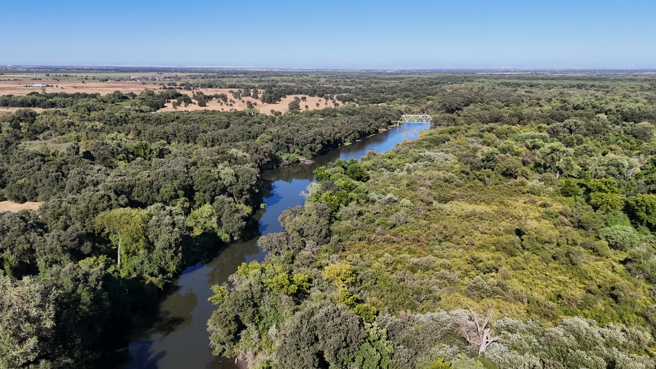
From the Air
The Cosumnes River flows roughly west from the Sierra Nevada foothills to the Sacramento-San Joaquin Delta, crossing flat agricultural land southeast of Sacramento. Coordinates approximately 38.26°N, 121.44°W at Michigan Bar. The river is visible from altitude as a winding green riparian corridor through brown and green patchwork farmland. The nearly 50,000-acre Cosumnes River Preserve is distinguishable as a large block of wetland and woodland south of Elk Grove. Nearby airports include Sacramento Executive Airport (KSAC) to the northwest and Sacramento Mather Airport (KMHR) to the north. Best viewed at 2,000-4,000 feet AGL, especially during winter when flooded fields catch the light.
Nearby Stories
- Eight Hours at the Good Guys 2.9 km away
- Joint Genome Institute 4.9 km away
- Where Salt and Fresh Water Negotiate 8.1 km away
- The Glory Hole: Monticello Dam and the Drain That Swallows a Lake 10 km away
- Gold Country 22 km away
- Altamont Free Concert 27 km away
- From Aluminum to Ammunition to Aviation Fuel 28 km away
- Sutter's Mill 34 km away