Cotopaxi
On a clear morning from Quito, the cone is visible sixty kilometers to the south - a nearly symmetrical white pyramid rising against blue sky. Ecuadorians know its moods well enough to read them from the capital. A thin wisp of steam from the summit means quiet. A thick plume means something else. In August 2015, the plume grew thick and stayed that way for five months. People who had forgotten that Cotopaxi was alive remembered quickly. The volcano is one of the highest active ones on Earth, and it has erupted repeatedly across recorded history, and it is not finished.
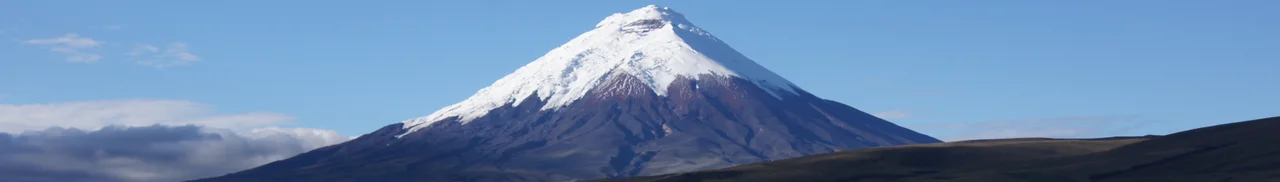
A Perfect Cone
Cotopaxi stands at 5,897 meters - roughly 19,347 feet - making it the second-highest peak in Ecuador after Chimborazo and one of the most iconic stratovolcanoes on Earth. The shape is textbook: a perfect conical mountain with a crater 800 meters wide and 250 meters deep at its summit, flanked by glaciers that descend to around 4,800 meters. The ice at the top looks pristine from below. It is also what makes Cotopaxi particularly dangerous. When the volcano erupts, the heat melts glacial ice rapidly, producing lahars - volcanic mudflows capable of traveling faster than a person can run, carrying house-sized boulders, and obliterating anything in their path. The town of Latacunga, immediately south of the volcano, has been destroyed by Cotopaxi lahars at least three times in recorded history.
The National Park
Parque Nacional Cotopaxi was established in 1975 as part of Ecuador's national park system. It covers ground typical of active volcanic areas - broad paramo grasslands at higher elevations, scrubby Andean woodlands in protected valleys, and several peaks above 4,000 meters including the dormant Ruminahui volcano, named for the Inca general who burned Quito rather than surrender it to the Spanish. The paramo here serves a function beyond scenery: the spongy high-altitude vegetation acts as a natural water filter, capturing and slowly releasing meltwater from Cotopaxi's glaciers into streams that feed Quito's water supply. The ecosystem is both beautiful and utilitarian. Much of what makes Quito livable begins on these grassy slopes.
What Lives Here
Cotopaxi's protected areas shelter wildlife that has mostly retreated from the lower altitudes where people have settled. Andean condors - increasingly rare, their numbers threatened across their range - can still be seen here on lucky days, soaring on thermals that rise off the volcano's warmed flanks. Spectacled bears, the only bear species native to South America, inhabit the more remote valleys. Brocket deer move through the woodlands. Foxes, white-tailed deer, and rabbits are more common sightings on the grasslands. The landscape supports less biodiversity than the lower cloud forests - altitude does that - but what does live here is unusual, adapted to thin air, UV radiation, and nights that drop below freezing year-round.
The Climb
By Ecuadorian law, Cotopaxi's summit can only be climbed with a registered guide. The reasons are practical: crevasses open across the upper glaciers, weather changes fast at altitude, and the slope from the refuge to the summit demands genuine mountaineering experience. The José Félix Ribas Refuge - built in 1971 by the Mountaineering Club of the San Gabriel School - sits at 4,864 meters, a stone and wood shelter with bunks, a kitchen, and a cathedral view. Climbers leave well before dawn, typically midnight, aiming to reach the summit at sunrise before the sun weakens the snow bridges. The round trip takes eight to twelve hours. The air at the top contains roughly half the oxygen of sea level. When climbers stand on the crater rim, what they see below them is Ecuador spread out in all directions - glaciers, paramo, and beyond them the green quilt of the inter-Andean valley.
August 2015 and After
The 2015 eruption ended a period of relative quiet that had lasted since the nineteenth century. It began with ash emissions on August 14 and continued through January 2016, producing moderate explosions and persistent ash plumes that dusted nearby farms and closed Mariscal Sucre airport intermittently. No one died, but thousands were evacuated from high-risk zones around Latacunga and surrounding valleys. The government built or reinforced lahar warning systems along the known mudflow paths. Ash continued to vent from the crater through 2023, when reports noted heavy ash clouds that required climbers to carry masks and goggles. Cotopaxi is monitored continuously by the Instituto Geofisico of Ecuador's Escuela Politecnica Nacional. The volcano is neither dormant nor currently in major eruption - it exists in the middle category that volcanologists watch most carefully. The mountain rises, the glaciers recede, the paramo holds. Quito fills its reservoirs. Every morning, from clear vantage points in the city, the cone becomes visible again. Still there. Still watching.
From the Air
Coordinates 0.68 S, 78.44 W. Summit elevation 5,897 meters (19,347 feet). Located approximately 50 km south-southeast of central Quito. One of the world's highest active volcanoes; ash emissions can periodically affect aviation in the region. Active monitoring by Instituto Geofisico of Ecuador. Best viewing altitude 15,000-20,000 feet in clear weather; often cloud-capped in the afternoon. Nearest airport: Mariscal Sucre International (SEQM) to the north; Cotopaxi International (SELT) in Latacunga to the south.
Nearby Stories
- Cubana de Aviación Flight 389 11 km away
- La Mana 16 km away
- Baeza 25 km away
- Tena 28 km away
- Ambato, Ecuador 41 km away
- Valencia, Ecuador 47 km away
- Quinindé Canton 87 km away
- Guandera Biological Station 111 km away