
Davenport Downs Station
In 1992, the Australian Army went to war against cats. The battlefield was Davenport Downs, the largest cattle station in Queensland, and the enemy was a population of feral cats so destructive that the state's environment minister sent in sharpshooters. Over three days they culled about 500, one of them tipping the scales at 8.2 kilograms, a feline grown monstrous on a diet of native wildlife. They were there to protect something small and increasingly rare: the bilby, the long-eared, burrowing marsupial whose last strongholds happened to lie on this remote run.
An Empire of Grass and Water
Davenport Downs is vast even by outback standards. Run together with neighbouring Springvale by the Paraway Pastoral Company, the aggregation covers some 15,100 square kilometres, making it the biggest cattle station in Queensland and the fourth largest in all of Australia, behind only Anna Creek, Alexandria, and Clifton Hills. The country is Mitchell-grass downland in the heart of the Channel Country, roughly 184 kilometres southeast of Boulia. What makes it work is water, from two directions. Below ground, bores tap the ancient pressure of the Great Artesian Basin. Above it, the Diamantina River and Farrar's Creek both cross the property, and in the wet season they routinely flood about a quarter of the station, leaving behind the explosion of feed that fattens the cattle.
Costello, Rutherford, and the Long Line of Owners
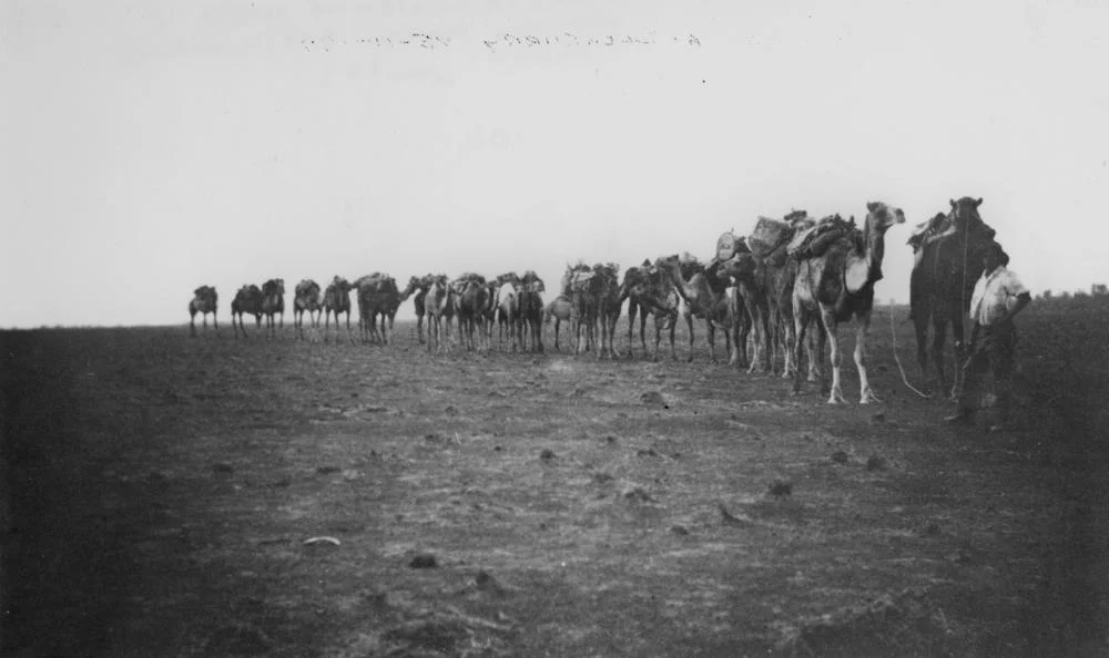
The lease was first taken up in the late 1860s by the pioneer pastoralist John Costello, and soon passed to James Rutherford, a prominent figure who held it alongside a string of other Queensland runs. When Rutherford's estate sold the property in 1913, the inventory captured the strangeness of the place and time: 20,200 cattle, 340 horses, 68 camels, and two artesian bores, all changing hands together for 67,000 pounds. The camels are no accident. In the rainless reaches of the inland, camel trains were the lifeline, and an old photograph shows one strung out between Winton and Davenport Downs in 1911. Ownership rolled on through the decades, through drought years and flood years, until the Paraway Pastoral Company bought Davenport in 2009 and Springvale in 2011, stitching the two into a single enterprise.
A Land That Floods and Forgets
Distance out here is measured differently. When airmail to remote stations finally began in 1949, Davenport Downs was one stop on a route that read like a poem of isolation: Mungerannie, Clifton Hills, Glengyle, Cordillo Downs, Nappa Merrie, Naryilco. The country could also be lethal. In 1930 the body of a man recorded only as J. Lelanes was found at a wayside camp here, believed to have died of thirst somewhere between Windorah and Springvale, his remains later carried off by floodwaters, an end that captures both of this land's faces at once: the killing dryness and the drowning flood. Yet from that same harshness comes refuge. In 1995, the state resumed part of the station as the core of what became Astrebla Downs National Park, then home to around 350 bilbies, roughly a third of all that survived in Queensland.
When the Diamantina Dances
Photographs taken from orbit show Davenport Downs surrounded by floodwaters, the Diamantina spreading into a shining web across the plain. This is the Channel Country's signature trick. Rain that fell far to the north, weeks earlier and hundreds of kilometres away, arrives here as a slow, broad sheet of water finding its way toward Lake Eyre. For a station built on Mitchell grass, the flood is not a disaster but a harvest, the moment the desert turns briefly into pasture. Then the water draws back into the channels, the cracked clay returns, and the cattle, the bores, and the bilbies settle in once more to wait for the next time the river comes down.
From the Air
Davenport Downs Station centres on roughly 24.15 degrees south, 141.10 degrees east, in the Diamantina Lakes district of the Channel Country, about 184 km southeast of Boulia and 262 km northeast of Birdsville. From the air, the standout feature is the braided, multi-channel course of the Diamantina River and Farrar's Creek crossing flat Mitchell-grass downs; in the wet season, watch for sheet flooding covering up to a quarter of the property in a shining anastomosing web that is dramatic from cruising altitude. Nearest airstrips include Boulia (YBOU) to the northwest and Birdsville (YBDV) to the south; Longreach (YLRE) is the major regional hub to the east. Dry-season visibility is excellent with heat haze and possible dust; in flood, the watercourses make an unmistakable navigation reference.
Nearby Stories
- Astrebla Downs National Park 7.3 km away
- Diamantina Lakes Station 16 km away
- Coorabulka 38 km away
- Palparara 54 km away
- Canterbury, Queensland 104 km away
- Burke and Wills Plant Camp 111 km away
- Warbreccan 119 km away
- Lark Quarry Dinosaur Trackways 123 km away