
Din Dryfol
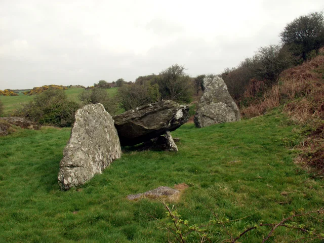
If you find Din Dryfol on a quiet weekday afternoon, you will probably have it entirely to yourself. The chambered tomb sits on a small platform on the flank of a low hill in central Anglesey, near the farmland edge of Aberffraw parish, with no car park and no signage to speak of. What greets you is one big capstone that slipped sideways centuries ago and now leans against the side stones it once roofed, plus a single huge portal stone standing three metres tall some distance away, like a punctuation mark in the grass. It is the patient, undramatic kind of prehistory that survives precisely because nobody made it famous.
Built in Three Acts
Din Dryfol is not a single monument but a sequence. Excavations in 1969-70 and again in 1980, conducted by the archaeologist Frances Lynch, identified three successive chambers built along a northeast-southwest axis. The first chamber - the one that is still partly visible - was a rectangular box about three metres by two, constructed with side slabs supporting a capstone that has since slipped to rest on the ground. The second chamber was added later to the northeast of the first; nothing of its stonework remains, though two postholes mark where wooden uprights once stood. The third chamber, further to the northeast again, was about five metres long and is now represented by a single small upright, a stone stump that may have been a portal, and the surviving three-metre portal stone standing well away from the rest. The whole assembly was once buried under a long mound of earth and rubble, perhaps 65 metres long and 15 metres wide. The mound is long gone. The skeleton of the chambers remains.
An Irish Idea on a Welsh Hill
Passage graves of the Din Dryfol type are more common in Ireland than in Wales. The tradition reached Anglesey by sea, brought by communities who maintained ties along the Atlantic coast through the fourth and third millennia BC. The first phase of the tomb was probably constructed about 5,000 years ago, putting it within a few centuries of the great Irish passage tombs at Newgrange, Knowth and Dowth. Like its more famous Welsh cousins Barclodiad y Gawres and Bryn Celli Ddu, both also on Anglesey, Din Dryfol is part of a small western Welsh chapter of the larger Atlantic story. The successive chambers may indicate generations of use, with each new chamber added as a fresh act of remembrance, building family or tribal history into the architecture itself.
Pottery and Pyre
Excavations turned up pieces of pottery and the remains of cremation sites - the basic evidence of how the tomb was used. The cremated bone, the shards of carefully fired Neolithic ware, the layout of the chambers all point to a place where the dead were processed, displayed, eventually packed away. The monument was first formally recorded in 1871 by an antiquary named H. Pritchard, but it was Lynch's two campaigns a century later that pieced together the construction sequence and the dating. Without those excavations, the site would still look like a heap of stones in a field. With them, it becomes a 5,000-year-old building project that someone kept extending for generations.
The Quiet Cadw Tomb
Din Dryfol is a scheduled monument in the care of Cadw, but it is not on the usual tourist circuit. There is no on-site interpretation, no entry charge, no opening hours. You walk in from a quiet lane, cross a stile, and find the tomb where it has always been. The lack of fuss is part of what makes the visit memorable. Standing next to the leaning capstone, with sheep grazing thirty metres away and Snowdonia visible on a clear day across the Menai Strait, you are doing more or less exactly what an Anglesey farmer might have done five hundred years ago, or fifteen hundred, or three thousand - looking at this strange leftover from people whose names have not been remembered and trying to imagine why they put these stones here. The answers are mostly gone. The stones are not.
From the Air
Din Dryfol sits at 53.23 degrees north, 4.40 degrees west on south-western Anglesey, in farmland about a mile north-west of Bethel hamlet and three miles inland from the coast at Aberffraw. The tomb is small and hard to identify from the air; look for the flat farmland north of the Malltraeth estuary. Best viewed at 1,500-2,500 feet. RAF Valley (EGOV) is five miles north-west - watch for fast-jet training and Valley MATZ. Caernarfon Airport (EGCK) lies 11 nautical miles south-east across the Menai Strait.
Nearby Stories
- Wakestock 1.7 km away
- Trefriw 3.8 km away
- Irish Sea 8.7 km away
- Irish Sea Bridge 20 km away
- East–West Interconnector 30 km away
- Machynlleth 36 km away
- HMS Tyler 41 km away
- New Brighton Lifeboat Station 54 km away