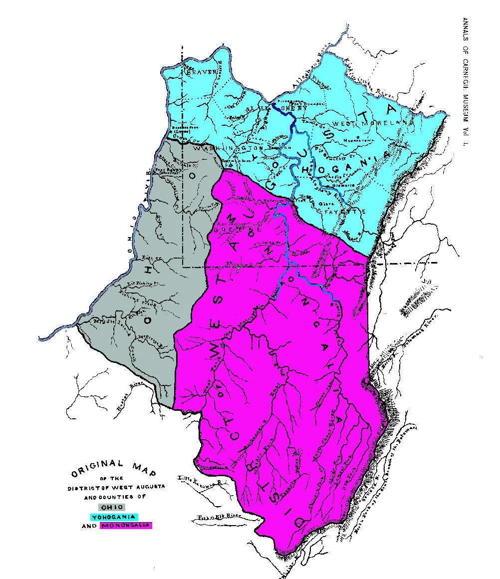

District of West Augusta
For two years in the mid-1770s, Pittsburgh was a Virginia town. The Royal Governor of Virginia, Lord Dunmore, traveled there in person to appoint local officials under the Virginia charter; Virginia sheriffs arrested Pennsylvania sheriffs and vice versa; settlers had to pick which colony's land office they preferred. The contested territory was called the District of West Augusta, and it covered most of what is now southwestern Pennsylvania - including Pittsburgh - and a substantial wedge of what is now northern West Virginia. The district lasted from 1774 to 1776. By the time the Revolution had gotten properly underway, both colonies had bigger problems, and within a few years the boundary was settled by extending the Mason-Dixon line west. But for those two years, the map of British America looked very different from the one we now know.
Two Colonies, One Tract
The conflict had its roots in the imprecise grants of the seventeenth century. Virginia's 1609 charter ran 'up into the land throughout from sea to sea, west and northwest' - language that, taken literally, meant Virginia stretched across the entire continent. Pennsylvania's 1681 charter granted William Penn a more limited but still ambiguous western boundary. The two colonies' claims overlapped substantially in the country west of the Allegheny Mountains, but as long as the French held the Ohio Valley, the dispute was academic. After the French and Indian War (1754-1763) opened the country to British settlement, the contention became serious. Virginia administered the region as part of Augusta County, an enormous and impossibly large jurisdiction that nominally ran from the Shenandoah to the Mississippi. Pennsylvania, for its part, organized Westmoreland County with a seat at Hannastown, and the two systems began running parallel courts, sheriffs, and tax rolls in the same territory.
Lord Dunmore Comes West
John Murray, 4th Earl of Dunmore, was the last Royal Governor of Virginia. He was an aggressive defender of Virginia's territorial claims, and in 1774 he traveled in person to Pittsburgh - which Virginia held by force at Fort Pitt, then renamed Fort Dunmore in his honor - to appoint Virginia officials under the colonial charter. That same year, the Virginia House of Burgesses formally separated the western portion of Augusta County into a new entity called the District of West Augusta. The legislation defined its boundaries by way of major rivers and ridgelines: starting at Haystack Knob in what is now Pocahontas County, running along the ridge that divides the Cheat River watershed from the Greenbrier, descending to the Monongahela, then up its West Fork and across the heads of Middle Island Creek to the Ohio. Everything north and west of that line was West Augusta.
Arrests on Both Sides
The years 1774 through 1776 were genuinely chaotic in the disputed country. Virginia officials and Pennsylvania officials administered the same territory under different statutes. Each tried to enforce its laws against the other's settlers. Sheriffs were arrested when they crossed boundaries that were not clearly drawn. Both colonies tried to slow the flow of settlers loyal to the other side; both established competing land offices that issued conflicting titles to the same parcels. The center of West Augusta's government was Fort Dunmore in Pittsburgh, but the seat was later moved to Augusta Town in what is now Washington County, Pennsylvania, where in August 1776 the first court west of the Monongahela held session. By that point, the Revolution had been declared, and the contest between Virginia and Pennsylvania was rapidly being overtaken by the contest between the colonies and Britain.
Three Counties Out of One
Later in 1776, the Virginia legislature broke the District of West Augusta into three new counties: Ohio County, Monongalia County, and Yohogania County. Ohio County ran along the Ohio River north and south of Wheeling; Monongalia County took in much of what is now north-central West Virginia and reached up into what is now Pennsylvania; Yohogania County covered most of southwestern Pennsylvania, including Westmoreland and parts of Allegheny, Washington, Fayette, and Beaver counties. The new structure was Virginia's attempt to consolidate its administration over a contested region by replacing one big problematic district with three smaller workable ones. Pennsylvania, which still claimed the same ground, refused to recognize any of it. The contradictions accumulated through the late 1770s as both colonies fought the British and tried to administer overlapping territory at the same time.
The Line Goes West
The matter was settled by negotiation in 1780. Virginia and Pennsylvania agreed to extend the Mason and Dixon line - the boundary that ran east-west between Maryland and Pennsylvania, surveyed in the 1760s by Charles Mason and Jeremiah Dixon - westward to 80 degrees 31 minutes west longitude, the current western edge of Pennsylvania. Everything north of the extended line belonged to Pennsylvania; everything south to Virginia. The agreement effectively dissolved Yohogania County: most of its territory passed to Pennsylvania and was divided between Westmoreland County and a new Washington County (with Allegheny and Beaver counties carved out later). The small remnant of Yohogania that lay south of the new line was absorbed into Ohio County, Virginia - which a century later, in 1863, became Ohio County, West Virginia. Brooke and Hancock counties, at the northernmost tip of West Virginia's Northern Panhandle, were carved out of that Ohio County in turn. The District of West Augusta exists today only as the name on a few historical markers and an unusually evocative footnote in the political geography of the early Republic.
From the Air
The District of West Augusta is a historical jurisdiction with no current physical boundaries, but the coordinate point (39.12 N, 80.18 W) places this in central West Virginia, near the historical southeastern boundary the district described. The relevant geography to visualize from the air includes the Monongahela River drainage (visible flowing north from West Virginia to Pittsburgh), the Ohio River along the western edge, and the Allegheny ridges that the original boundary description traces. Best appreciated at higher altitudes (8,000-12,000 feet) where the river systems and mountain ridges that shaped the dispute become visible at once. Major airports in the historical region include Pittsburgh International (KPIT) at the original West Augusta capital.
Nearby Stories
- Appalachia 13 km away
- State of Kanawha 17 km away
- Weston and Gauley Bridge Turnpike 18 km away
- Tucker County, West Virginia 20 km away
- Sinks of Gandy 20 km away
- Garrett County, Maryland 46 km away
- The Ohio River Museum 51 km away
- West Virginia Penitentiary 70 km away