
Doonshean
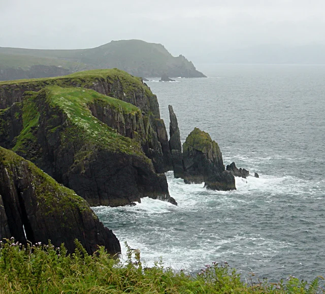
Out beyond the small beach at Trá Bheag, a sea stack rises from the water in a shape that the Irish-speaking locals long ago decided looked like a young horse. They called it the Siorrach — 'the foal' — and the name has stuck through centuries of sea-haze and storm. This is Doonshean, or Dún Síon in Irish, a townland of grassy headlands and stone-walled fields a few kilometres east of Dingle. The name itself comes from a nearby promontory fort, Doonmore, where dún means fort and síon derives from síneadh, 'a stretch of land.' The whole place is exactly that: a stretch of land, ending suddenly in cliffs above the Atlantic.
A Fort on the Edge
The promontory fort that gives the area its name sits on a finger of land thrust into the sea — a classic Iron Age defensive site of the Atlantic seaboard. To reach it you walk through fields, climbing over stiles in stone walls, until the ground simply runs out. A short defensive bank cuts off the tip of the headland from the mainland: with the sea on three sides and a wall on the fourth, the position was easy to defend and hard to surprise. There are no visitor centres here, no signs, no guided trails. The fort is simply there, where it has been for two thousand years or more, and you find it the way the people who built it would have understood: by walking out.
The Sea Stack Called Foal
From the beach below, the Siorrach stands offshore, its profile catching the light. Sea stacks form when waves and weather isolate a column of rock from a retreating cliff, leaving it standing alone in the surf. They are temporary in geological terms — every storm chips at them, every freeze-thaw pries at their joints — but on a human timescale they feel eternal. The Siorrach has been called 'the foal' for as long as anyone can remember, the comparison perhaps clearer in soft evening light than at midday. Trá Bheag — the 'small beach' — curls in below the headland, sheltered enough to be walkable in most weathers, exposed enough to remind you what ocean is.
The View Across
From Doonshean's beach the eye carries across the water to the village of Kinard, sitting on its own small bay in the neighbouring parish of Lispole. Between, Dingle Bay opens wide toward the Iveragh Peninsula on the southern horizon. The headlands here are a tangle of ring forts, enclosures, and other prehistoric earthworks — the kind of landscape archaeologists describe as densely settled in deep time. Walking the cliffs, you pass low circular banks and shallow ditches where farmers two thousand years ago marked off pasture and cornfield. The pattern has not entirely changed: the modern fields above the cliffs are still small, still stone-walled, still grazed by black cattle and sheep that have learned to handle the wind.
Mícheál's Birthplace
One of Ireland's most beloved voices came from this slope of fields. Mícheál Ó Muircheartaigh, the legendary Gaelic games commentator whose radio call defined All-Ireland finals for half a century, was born in Dún Síon. His memoir, From Dún Síon to Croke Park, took its title from the journey — from a small townland on the western edge of Kerry to the great Dublin stadium where Ireland watches its national sports. His voice, when he commentated in Irish or in English, carried the cadence of this country: rapid, musical, full of asides, never quite literal. Listening to him call a match was like listening to someone tell a story that happened to also be a game. The voice came from here. The fields, the foal-shaped stack, the wind off Dingle Bay — they were the music underneath it.
From the Air
Located at 52.13°N, 10.23°W, about 3.8 km east of Dingle town along the south coast of the Dingle Peninsula. The promontory fort and the Siorrach sea stack make the headland visually distinctive from the air. Nearest airport is Kerry (EIKY), roughly 45 km east. Recommended viewing altitude 1,500–3,000 feet for the sea stack and cliff outlines. Best in morning light, when the eastern face of the stack catches the sun and the headland casts long shadow patterns across the green fields.
Nearby Stories
- Ballyheigue Castle 1 km away
- Killemlagh Church 2.8 km away
- Pouldergaderry Sinkhole 6.8 km away
- Derreen Garden 11 km away
- Kilkee 59 km away
- The Laki Eruption: The Volcano That Changed World History 1366 km away
- The Northern Lights: The Sky Show That Vikings Thought Was Bridge to the Gods 1469 km away
- Sao Miguel 1935 km away