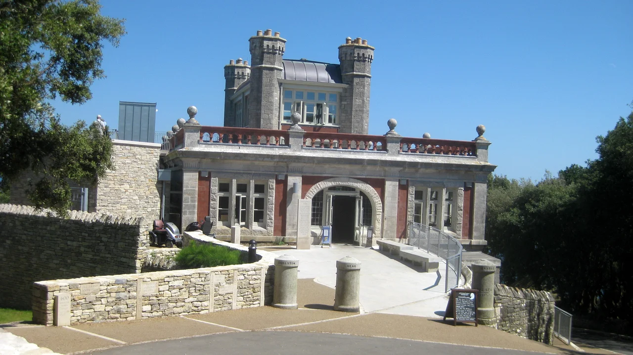

Durlston Castle
It was never a castle. George Burt knew that perfectly well when he commissioned it in 1886 as a stone-built restaurant on the cliffs south of Swanage, but the locals were going to call it a castle anyway, so he leaned into the joke. He gave it battlements. He carved Shakespeare and Bible verses into the surrounding walls. He commissioned a forty-ton stone globe of the Earth and set it just downhill. And then, because limestone quarrying had made him very rich indeed, he kept adding. By the time he was finished, the headland above Durlston Bay had become the strangest Victorian theme park in Dorset.
The Stonemason's Nephew
George Burt was born in Swanage in 1816, into a quarrying town that had been carving Purbeck and Portland limestone for centuries. His uncle, John Mowlem, had left Swanage as a young man and built one of the great Victorian construction firms, the company that still bears his name. Mowlem brought his nephew into the business, and together they paved London with Dorset stone. By 1862, with money pouring in from quarries and contracts, the two of them set about giving something back to their hometown. Mowlem built a reading room and public library, the Mowlem Institute. Burt bought a chunk of the cliffs at Durlston Head, including the quarries that supplied their firm, and set about turning it into a tourist attraction.
Castle by Appointment
Burt commissioned the Weymouth architect G. R. Crickmay to design what he called a castle, and W. M. Hardy to build it, entirely from the local stone. It went up in 1886 and 1887, three storeys of crenellated limestone with a sundial and inscribed tablets giving clock times in distant cities and tide tables for the world. The point was always practical. The 'castle' was a restaurant, designed to feed and entertain the day trippers Burt expected to walk down from Swanage to enjoy his cliffs. Around it, between 1887 and 1891, he installed the rest of his vision: cast iron bollards shipped down from London, stone plaques carved with quotations from Shakespeare and the Bible, maps of the English Channel and the United Kingdom rendered in stone, and miscellaneous facts about the natural world arrayed along the footpaths. Visitors were meant to learn as they walked.
The Great Globe
South of the castle, set into the grass on the cliff edge, sits the object that made Burt's estate famous. The Great Globe was carved in 1887 from fifteen sections of Portland limestone, weighed roughly forty tonnes, and represented the world at a scale of about one inch to 130 miles. The continents were carved in relief. The oceans were named. Around the globe, more stone tablets gave latitudes, longitudes, distances between cities, and improving thoughts about creation. It was Victorian self-improvement made literal: a piece of public sculpture that doubled as a geography lesson, set down at the end of a hilltop walk with the English Channel behind it. The globe has weathered for over a century now, the carved features softened by salt and rain, but it remains one of the most photographed stone objects in Dorset.
Marconi on the Roof
In the 1890s, an engineering team working for Guglielmo Marconi climbed onto Durlston Castle's roof and used it as a transmission point for some of the earliest practical experiments in wireless telegraphy. They were trying to send signals across to the Isle of Wight, twenty miles east across the Channel. The castle was an obvious choice: it stood high and exposed on the south coast, with nothing between it and Marconi's other stations except open water. Those experiments were part of the broader work that established radio as a workable technology by the turn of the century. The castle changed hands repeatedly after that, drifting through private owners until Dorset County Council bought it in 1973. It was made a Grade II listed building in 1983.
Gateway to the Coast
In 2010 and 2011 the Council restored both the castle and the Great Globe. The building now serves as the visitor centre for Durlston Country Park and National Nature Reserve, a 280-acre stretch of coastal grassland, woodland and limestone cliff that forms part of the Jurassic Coast World Heritage Site. There is a cafe, an art gallery, and a clear viewpoint south across the Channel. Walking paths lead out to Tilly Whim Caves, the Anvil Point Lighthouse, and the bird-rich cliffs where guillemots and razorbills nest in spring. Burt's quirky restaurant, with its inscribed walls and its giant stone Earth, has become exactly what he hoped it would be: the front door to one of the loveliest stretches of the English coast.
From the Air
Located at 50.595°N, 1.953°W on the south-eastern tip of the Isle of Purbeck, immediately south of Swanage. The castle sits at about 100 metres elevation on the cliff edge, with the Great Globe visible nearby on the hillside. Best viewed from 1,500-2,500 feet on a clear day. Nearest airfields: Bournemouth Airport (EGHH) 18 nm east-north-east, Compton Abbas (EGHA) 28 nm north-west. Anvil Point Lighthouse is a clear navigational reference just south-west along the same headland.
Nearby Stories
- Calshot Castle 7.3 km away
- Battle of Portland 16 km away
- Sherborne Castle 16 km away
- Carisbrooke Castle 18 km away
- German Submarine U-672 25 km away
- Wardour Castle 28 km away
- Operation Donnerkeil 31 km away
- D-Day: The Longest Day 141 km away