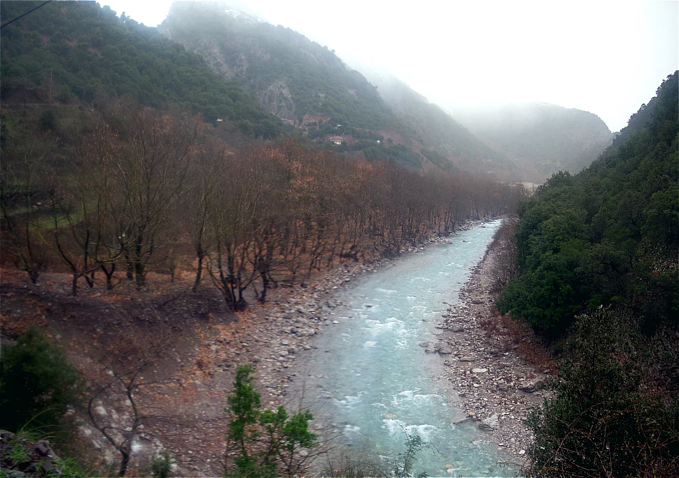

Evrytania
Greeks sometimes call Evrytania the 'Greek Switzerland,' though the comparison flatters Switzerland. The Alps are grand but well-mapped, well-roaded, well-tamed. Evrytania is something older and stranger: a region of central Greece where the Pindus Mountains pile into each other without apology, where the Acheloos and Megdova rivers cut gorges that were, until recent decades, genuinely impassable for months at a time, and where the Ottoman Empire — which controlled virtually all of Greece for four centuries — never quite managed to write this place into its administrative record. The name of one of Evrytania's sub-regions, the Agrafa, means 'the unwritten' in Greek. The Ottomans, quite simply, could not get their tax collectors in. That is the spirit of the place: forested, folded, and uninclined toward compliance.
Mountains All the Way Down
Evrytania is almost entirely mountains. The Tymfristos, rising to 2,315 meters just north of the regional capital Karpenisi, is the dominant peak, its slopes home to a ski resort that draws visitors in winter from across central Greece. The Panaitoliko range occupies the south. Between these massifs, rivers carve their paths: the Acheloos runs along the western edge, the Agrafiotis threads through the east, and the Megdova drains toward the Ionian Sea. The region borders Aetolia-Acarnania to the west, Karditsa to the north, and Phthiotis to the east — all of them regions of relative accessibility compared to Evrytania's interior. The climate shifts between Mediterranean in the lower western valleys and proper alpine in the heights: heavy snow in winter, warm and dry in summer, with conditions that make the place simultaneously beautiful and demanding.
Eight Thousand Years of Difficult Neighbors
People have lived in this terrain since around 6000 to 5000 BC. In classical antiquity, the inhabitants were an Aetolian tribe called the Eurytanes, who gave the region its name. The Romans absorbed Evrytania in the 2nd century BC following the collapse of the Aetolian League, and it passed from Roman to Byzantine hands as the empire divided. After the Fourth Crusade in 1204, it fell within the Despotate of Epirus. The Ottomans arrived around 1450, claiming the rest of Greece as their empire expanded westward. Evrytania's geography offered a different kind of resistance from the one armies provide: the roads simply did not cooperate. The eastern and southern parts of the region came under Ottoman administrative control, but the area around the Agrafa managed something remarkable — a form of continuous self-governance and semi-independence recognized by the Ottomans themselves in a treaty of 1525. The mountains, in other words, negotiated for their inhabitants.
When Independence Came
Evrytania was a staging ground for the Greek War of Independence, which began in 1821. The region's remoteness, which had been a burden for centuries, became an advantage. Mountain passes made excellent ambush points; monasteries served as headquarters and hospitals; the local fighters — many of them descended from families who had maintained their independence for generations — knew the terrain in ways that invading forces never could. After independence, Evrytania was formally incorporated into the Greek state, created as a separate prefecture in 1947. The 2011 Kallikratis government reform reorganized it as a regional unit of Central Greece, subdivided into two municipalities: Karpenisi and Agrafa. Peace returned to the region after the Greek Civil War in the late 1940s, but it brought another kind of disruption: migration. Younger residents left for Athens, Thessaloniki, and further abroad, seeking work in cities that offered what the mountains could not.
Notable Evrytanians
The people who came from these mountains have left marks well beyond them. Georgios Kondylis, born in 1878 in Karpenisi, rose to become a general and eventually Prime Minister of Greece. Zacharias Papantoniou, born in 1877, was one of the early 20th century's significant Greek writers. Stefanos Granitsas, who lived from 1880 to 1915, worked as an artist, writer, and journalist before dying young. Ioannis Theodoropoulos, also from Karpenisi, won a bronze medal in the pole vault at the 1896 Summer Olympics in Athens — the very first modern Olympic Games. Pavlos Bakoyannis, a liberal politician and journalist, was born here in 1935 and assassinated in 1989. The region has produced fewer famous faces than its size might suggest, which is partly a function of having fewer people, and partly a function of how long it took the roads to arrive.
Coming Here
The main road through Evrytania is the Greek National Road 38, which runs from Agrinio to Lamia and passes through Karpenisi. Since 2004, the road crosses into the neighboring region via the 1.4-kilometer Tymfristos Tunnel, cutting travel time to the rest of central Greece considerably. Before the tunnel, the pass over the mountain was closed by snow for significant portions of the year. Karpenisi itself, with roughly 8,000 inhabitants, is a pleasant mountain town with a ski resort and the kind of infrastructure that takes centuries of being the only real settlement in a rugged region to develop. The rest of Evrytania is small villages, forests, river gorges, and the occasional monastery perched on a cliff — which is, depending on what you are looking for, either a limitation or the entire point.
From the Air
Evrytania's center lies at approximately 38.948°N, 21.745°E, in the mountainous interior of central Greece. From altitude, the region appears as a dense corrugation of forested ridges with few visible settlements; the town of Karpenisi is the most identifiable urban feature, visible at the head of the Karpenisiotis valley with Mount Tymfristos rising steeply to its north. Recommended cruising altitude for area orientation is 8,000–12,000 feet, though individual valleys require much lower passes. The nearest major airport is LGBL (Nea Anchialos National Airport, near Volos), approximately 85 km to the northeast. Athens Eleftherios Venizelos (LGAV) is roughly 200 km southeast. Mountain weather can be severe; expect turbulence over the ridges, and plan for rapidly developing convection on summer afternoons.
Nearby Stories
- The 1954 Sofades Earthquake 3.4 km away
- Ypati 11 km away
- Lake Trichonida 13 km away
- Kommeno 14 km away
- Duchy of Neopatras 14 km away
- Lake Plastiras 16 km away
- Phaneromeni Monastery, Lefkada 19 km away
- Battle of the Echinades (1427) 34 km away