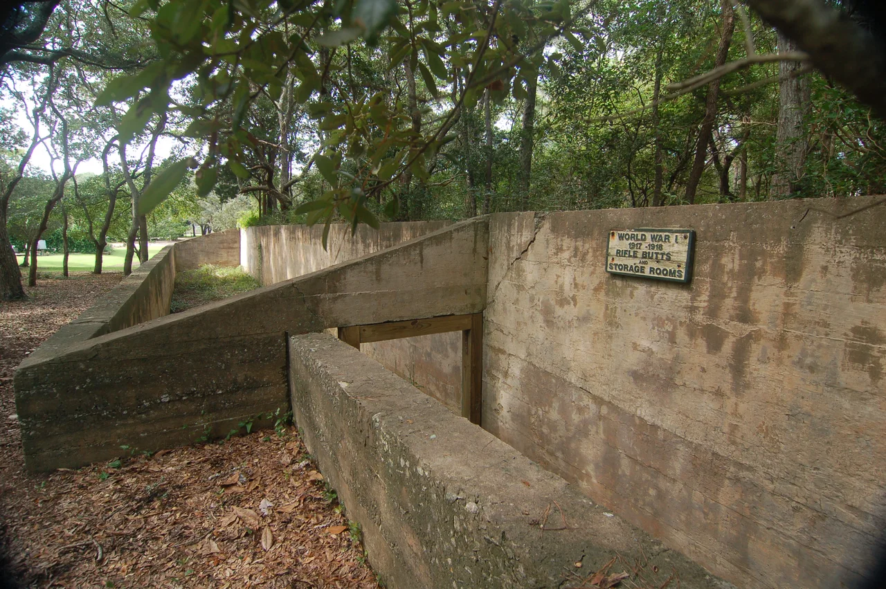

Fort Caswell Rifle Range
Carved into the south wall of a concrete trench in the middle section of a suburban housing development on Oak Island, North Carolina, someone inscribed a date: May 20th, 1918. The trench is mostly buried below grade, its eastern end roofed at construction but open now to the sky, with walls eight inches to a foot thick stretching 184 feet end-to-end through what is otherwise an unremarkable maritime forest. When the inscription was made, the soldiers training here were preparing to ship out to a war that had been grinding through its fourth year. France was six months away from armistice. Most of these soldiers would not be at the front long enough to see anything decisive happen. Some of them would not come back at all.
The War Department Order
The United States War Department approved construction of the Fort Caswell Rifle Range on January 21, 1918, nine months after America had entered the First World War and seventeen days after President Wilson had laid out his Fourteen Points to a joint session of Congress. The order was simple: build a small-arms training facility where soldiers stationed at Fort Caswell could practice marksmanship before deployment. Fort Caswell itself sat at the eastern end of Oak Island, guarding the mouth of the Cape Fear River. It had been built in the 1820s and 1830s, captured and destroyed by the Confederates during the Civil War, rebuilt in the late nineteenth century as a coast artillery post, and pressed into service in 1917-1918 as a training and patrol base. The rifle range was constructed a little over two miles west-northwest of the main fort, in what is now a residential neighborhood called Caswell Dunes. The structure went up quickly. By late May 1918 it was complete enough that someone wet a finger and drew a date into curing concrete.
How It Was Built
The rifle range is unusual as preserved military structures go. It is essentially a long below-grade trench, divided into three sections by interior walls and doorways. The eastern end, 14 feet long, originally had a roof and served as a storage room for targets and tools - paper bullseyes, ammunition, the wooden frames that held the targets up. A doorway led west into the center section, a 76-foot walkway between the storage room and the target area beyond. Another doorway opened into the western section, 94 feet long, where the actual targets stood. The walls slope from north to south. The 9.5-foot north wall is three feet taller than the south wall, designed to catch and stop the rounds fired by riflemen standing further north on what was then an open clearing. Concrete was the material of choice for permanence and for catching lead. The structure was meant to last well past the war that prompted it. It has.
Sold for Surplus, Reclaimed by Roots
After the Second World War, the War Department declared Fort Caswell - including the rifle range - surplus. Most of the main fort was sold to the North Carolina Baptist Assembly in 1949 and became a Christian retreat and conference center. The rifle range, two miles inland from the fort proper, was sold separately and left untended. For sixty years the structure sat in maritime forest, its walls slowly being levered apart by the roots of loblolly pines and live oaks that had grown up around it. Water seeping through the cracks worked at the concrete from the inside. The load-bearing supports across the interior doorways - the small spans of concrete that connected the wall sections - began to crack and pull away. By 2012 a structural engineer looking at the site might have given the trench another twenty years before something started to collapse. The Friends of Fort Caswell Rifle Range, a small nonprofit formed in 2015, started stabilizing the walls with contracted labor and volunteers. They have been at it ever since.
Centennial and the Brunswick County List
On April 5, 2018, the U.S. World War I Centennial Commission and the Pritzker Military Museum and Library announced that the Fort Caswell Rifle Range had been chosen as one of 100 WWI memorials nationwide selected for a restoration grant. The designation - WWI Centennial Memorial - was meant to mark sites of national significance from the conflict. On November 11, 2018, the 100th anniversary of the armistice, the Brunswick County WWI Monument was dedicated at the site. The monument honors the men from Brunswick County who fought in the First World War. Two years later, the Friends published a book - Brunswick County in the Great War - that contains biographical sketches of all known Brunswick County WWI service members. The book runs to several hundred pages. Many of the men sketched in it trained, briefly, in the trench that someone dated in wet concrete on May 20, 1918. They were ordinary men from the river towns and coastal villages of southeastern North Carolina, drafted or enlisted into a war whose causes most of them probably could not have explained in detail. The trench is now a small park in a residential neighborhood. You can walk down into it. The concrete is still cool in the summer.
From the Air
The Fort Caswell Rifle Range sits in the Caswell Dunes residential subdivision on Oak Island at approximately 33.90°N, 78.06°W, just inland from the south shore of the barrier island. From altitude the structure is invisible under tree cover - the trench is mostly below grade and surrounded by maritime forest. The main Fort Caswell historic district lies about two miles east-southeast on the eastern tip of Oak Island, identifiable by the Oak Island Lighthouse and the cluster of Baptist Assembly buildings. Recommended viewing altitude 2,000 to 3,500 feet AGL. Nearest airports: Cape Fear Regional Jetport (KSUT) at Oak Island 3 miles east, Wilmington International (KILM) 30 miles north, and Grand Strand Airport (KCRE) 32 miles southwest.
Nearby Stories
- Tabor City, North Carolina 12 km away
- Horry County, South Carolina 23 km away
- Leland, North Carolina 24 km away
- Huntington Beach State Park 30 km away
- Topsail Beach, North Carolina 31 km away
- Topsail Island 73 km away
- Atalaya Castle 79 km away
- Mercury-Redstone 4 696 km away