
Gaeltacht na nDéise
Park the car at Cé Heilbhic, walk down to the little fishing pier, and listen. The teenagers untying ropes on the boats are speaking Irish to each other. Inside the shop on the road back to Ring, the woman at the till asks the next customer the price of brown bread in the same language. The strange thing is that this is County Waterford - 200 kilometres from the Conamara coast where most outsiders place the Gaeltacht map. Gaeltacht na nDéise, the only Irish-speaking community in the entire province of Munster east of Kerry, holds on here in 62 square kilometres of coast and headland a short drive from Dungarvan. The remarkable thing is not that it has survived. The remarkable thing is that it has been growing.
Ring and the Old Parish
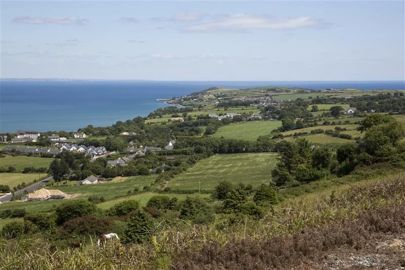
The Gaeltacht consists of two main areas: An Rinn (Ring), the rocky peninsula that juts south of Dungarvan Harbour into the Celtic Sea, and An Seanphobal (Old Parish), the inland farmland stretching west from there toward the Drum Hills. About 1,816 people live here, scattered across more than seventy townlands - many with names that could pass for poetry on their own. Baile na nGall Mór. Sliabh an Ghabhláin. Cnoc na gCapall, the hill of the horses. The coast is jagged, with sea cliffs and pocket beaches; the inland is patchwork pasture climbing into the Comeraghs. The Gaeltacht was first formally defined in 1956 and expanded in 1974, with the boundaries drawn townland by townland according to where Irish was still spoken at home.
A Language That Refuses to Slip
The 2006 community survey, carried out by Cork Institute of Technology because the population was small enough to canvass every household, gave a clear picture: 29.7 per cent of households used Irish as their principal home language, 86.3 per cent of adults could speak it, and over half of Irish speakers used it daily at home. When asked whether they wanted to keep their status as a Gaeltacht, 98 per cent said yes. The 2016 census produced something rarer still: Gaeltacht na nDéise was one of the few official Gaeltacht areas in Ireland to record an increase in daily Irish speakers. Most other Gaeltachts have been losing speakers for decades; here, the curve bent the other way. Under the 2012 Gaeltacht Act, the local development company Comhlucht Forbartha na nDéise was tasked with writing a seven-year language plan to keep that momentum going.
Working Coast
The economy is what you might expect of a small coastal community and a few things you would not. Commercial fishing still goes out from Cé Heilbhic, though the boats are fewer than they once were. Farming remains, especially in the Old Parish. Education employs a fair share of the local workforce - this is one of the few places in Ireland where a fully Irish-medium childhood is still possible, all the way from playgroup to Leaving Certificate. There is also a small but distinctive television-production sector that supplies the Irish-language broadcaster TG4 and exports content internationally. In 2019, Údarás na Gaeltachta - the state agency for Gaeltacht development - employed 149 people in its Waterford client companies, up from 121 in 2011. Old Parish, somewhat more inland and somewhat less prosperous than Ring, lags behind on most economic indicators.
Reilig an tSléibhe
Up in An Seanphobal there is a field that holds a memory the locals carried for a hundred and fifty years before they marked it. Reilig an tSléibhe - the mountain graveyard - is a famine burial ground. Historians believe there are perhaps three mass graves in the field, used in the worst stretches of the 1840s when more people were dying than the priests could keep up with; as deaths slowed, smaller individual graves were dug. None of the graves are marked. In 1995, for the 150th commemoration of the famine, a memorial was placed there inscribed with a verse of Máire Ní Dhroma's Irish-language famine poem Na Prátaí Dubha - The Black Potatoes. A solitary figure in mourning stands at the side of the field, made by the sculptor Seán Creagh; he died before finishing the bronze, and the fibreglass mould he had prepared was set up instead. A single marked headstone in the field belongs to G. R. Jacobs of HMT Bradford, who died at sea in 1916. Walking the perimeter on a quiet afternoon, you understand why the place does not need much signage.
Aonach an Phátrúin
Every December, just before Christmas, the Gaeltacht holds Aonach an Phátrúin, a Christmas market in Irish on the day of the local patron saint. The new tourism development committee, An Coiste Fáilte, has been quietly building these traditions back into the year: the famine graveyard restored, walking trails marked in Irish first and English second, the area's stops added to the Ireland's Ancient East tourism route. The strategy is straightforward. If outsiders come to hear the language used as a living thing - in shops, on the pier, at the playground An Imearlann - the language gains an economic reason to keep being spoken. So far the strategy is working. In a country where the Gaeltachts have generally been retreating, Gaeltacht na nDéise has been finding ways to stand its ground.
From the Air
Gaeltacht na nDéise sits at roughly 52.05°N, 7.58°W on the south coast of County Waterford, about 10 km from Dungarvan town. From the air, look for the An Rinn peninsula jutting south into the Celtic Sea, with Helvick Head as its tip - a small fishing pier sits just inside the headland. The Old Parish stretches inland to the west toward the Drum Hills and Comeraghs. The N25 Cork-Waterford road passes north of the area. Nearest airports: Waterford (EIWF) about 50 km east-north-east, Cork (EICK) about 80 km west, Shannon (EINN) about 160 km north-west.
Nearby Stories
- Kilcash Castle 3 km away
- Hook Lighthouse 7 km away
- Aghada 9.3 km away
- Tipperary (town) 11 km away
- Fermoy 13 km away
- County Wexford 28 km away
- Ballycotton Lighthouse 29 km away
- Skomer 120 km away