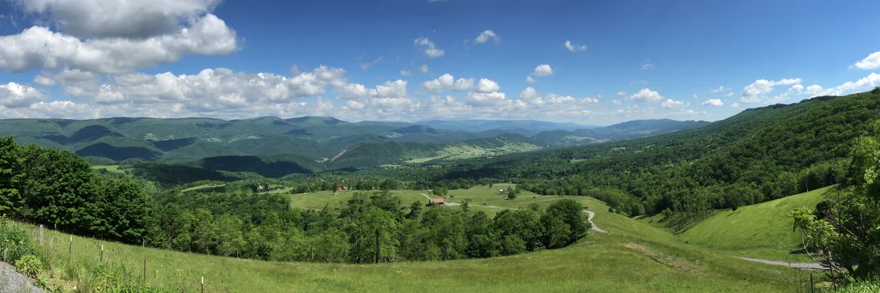
_on_the_western_slopes_of_North_Fork_Mountain_near_Monkeytown,_Pendleton_County,_West_Virginia.jpg)
Germany Valley
John Justus Hinkle was 56 years old when he moved his family from North Carolina to a remote West Virginia valley in 1761. He brought his wife, Maria Magdalena, their twelve children, and the children's families - a whole extended clan looking for cheap, fertile land and a little distance from the Indian raids that had destroyed Fort Seybert and Fort Upper Tract just three years earlier. The Hinkles were originally Henckel, German Lutheran farmers from the Lebanon and Lancaster counties of Pennsylvania. The valley they settled became known, naturally enough, as Germany Valley. The Hinkles painted hex signs on their barns - possibly the only place in West Virginia where they were ever seen. They built a fort. They held the valley. And the land they farmed turned out to sit on top of one of the most extensive cave systems in the eastern United States.
A Karst Valley with German Bones
Germany Valley runs about ten miles long and two and a half miles wide, oriented northeast to southwest in the upper reaches of the North Fork of the South Branch Potomac River in Pendleton County. The valley floor sits at about 2,100 feet, with the surrounding mountaintops 500 to 1,000 feet higher. North Fork Mountain bounds the valley on the east; the River Knobs bound it on the west. Geologically, the valley sits in the eroded core of the Wills Mountain anticline, with the Ordovician New Market limestone exposed on the valley floor. The limestone is what made the soil fertile. It is also what made the caves. The valley has dozens of mapped cave systems and was designated a National Natural Landmark - the Germany Valley Karst Area - by the National Park Service in 1973.
Hinkle's Fort and the Methodist Bishop
After the 1758 destruction of Fort Seybert and Fort Upper Tract by Bemino's war party, the Hinkle family built a blockhouse in Germany Valley in 1762 to defend their new settlement. Hinkle's Fort served as the local refuge and, by the time of the American Revolution, as the headquarters of the North Fork Military Company. The fort is gone today, but a large arrowhead-shaped stone monument enclosed by an iron fence marks its former site along the road east from Riverton. In June 1781, Bishop Francis Asbury - one of the two original Methodist missionaries in the United States - rode over North Fork Mountain to evangelize the valley. He preached to about ninety 'Dutch folk' who, in his words, 'appeared to feel the word.' Asbury also visited a large cave the locals showed him, which was known for over 150 years as Asbury Cave and is now called Stratosphere Balloon Cave.
Caves Below the Pasture
The caves of Germany Valley make up one of the most important karst landscapes in the eastern United States. Seneca Caverns, discovered by settler Laven Teter around 1780, has been open to the public since 1930. Visitors descend up to 165 feet below the surface along a three-quarter-mile prepared trail past formations named Mirror Lake, Niagara Falls Frozen Over, and the Capitol Dome. Schoolhouse Cave contained saltpeter works supporting Hinkle's Fort late in the French and Indian War. Memorial Day Cave, discovered by cavers in 1999, has been mapped to over 26 miles long and 430 feet deep. Hellhole, the most consequential of all, contains over 38 miles of mapped passage - the 7th longest cave in the United States. It is also a critical bat hibernaculum. Roughly 45 percent of the world's remaining Virginia big-eared bats - one of the most endangered mammals in North America - hibernate in Hellhole every winter.
The Quarry and the Bats
Greer Limestone Company operates an open-pit quarry in Germany Valley, immediately west of the Hellhole cave entrance. The company has leased the cave entrance from a private landowner since 1986. The conflict that emerged in the late 1990s and 2000s pitted the quarry's expansion plans against the cave's ecological importance. Cavers and federal biologists argued that quarrying could breach the cave system at a lower elevation than the entrance, draining the cold air trap that keeps Hellhole at 47 degrees Fahrenheit - a temperature critical to the bats' winter survival. Most other West Virginia caves average around 57 degrees. After prolonged negotiations involving the U.S. Fish and Wildlife Service, state agencies, caving organizations, and Greer, the Germany Valley Karst Survey was formally contracted in 2002 to map the full extent of Hellhole during a 16-week summer window when bats are not in residence. The survey expanded the known cave from 8.5 miles to nearly 25. The contract ended in 2007. The negotiations continue.
Family Names on the Map
Walk a topographic map of Germany Valley and you can read the genealogy of the original settlers in the place names. Judy Gap and Judy Spring honor the Judy family. Bennett Gap, Teter Gap, and Harper Gap mark the others. The named knobs - Harman, Harper, Mallow, Ketterman - all reflect old family lines. Dolly Ridge. Bland Hills. The valley has remained agricultural and isolated for generations, its economy based on forage crops, cattle, horses, dairy cows, and sheep, the same kinds of livestock the Hinkle family raised. Today Germany Valley is part of the Spruce Knob-Seneca Rocks National Recreation Area, though most of the valley land remains privately owned. The combination of the surface landscape - fertile farms, family names, churches - and the underground landscape of caves and bats makes the valley as layered ecologically as it is historically.
From the Air
Located at 38.77 degrees north, 79.39 degrees west, in Pendleton County, West Virginia. Best viewed from 4,000 to 6,500 feet AGL. The valley runs about 10 miles northeast-to-southwest at about 2,100 feet of elevation, with North Fork Mountain to the east and the River Knobs to the west. Seneca Rocks rises near the northern end. The Judy Gap overlook along U.S. Route 33 west of Franklin offers the classic view. Nearest airports are Grant County (KW99), Elkins-Randolph County (KEKN), and Shenandoah Valley Regional (KSHD).
Nearby Stories
- Reddish Knob 4.9 km away
- Allegheny Front 5.8 km away
- Randolph County 6.1 km away
- Green Bank Observatory 7 km away
- Battle of New Market 13 km away
- Barbour County, West Virginia 21 km away
- Rapidan Camp 29 km away
- Willa Cather Birthplace 46 km away