Gezira State
Gezira means island in Arabic. On a map of central Sudan, the geometry is obvious: the Blue Nile comes down from Ethiopia, the White Nile comes up from equatorial Africa, and between them lies a triangular wedge of land that functions, for irrigation purposes and for political ones, as an island. Five million people live here. Twenty-seven thousand square kilometers of cotton, wheat, and sorghum lean against one of the great agricultural schemes of the twentieth century, the Gezira Scheme, which from 1925 onward turned this land into Sudan's breadbasket and cotton exporter. On 15 December 2023, a Rapid Support Forces offensive crossed into Gezira from the west. By 18 December, according to the International Organization for Migration, 250,000 people had fled. The island turned out to be exactly as fragile as the word implies.
Before the Cotton
The Kingdom of Kush held sway here in antiquity. A Meroitic-speaking community lived on the Gezira plain; the area was the southern edge of Nubia, and archaeological work has been thin enough that the local ancient record remains mostly unfilled. For several centuries Gezira belonged to Alodia, the Christian kingdom based at Soba whose collapse in the early sixteenth century set the stage for new powers. Gezira then became the center of the Funj Sultanate, whose capital at Sennar on the Blue Nile remained important until the Turco-Egyptian conquest of 1821. The Wad Habuba Revolt at Katfia in April 1908 was an early sign that Sudanese resistance to British rule had not ended at Omdurman in 1898.
The Scheme That Changed Everything
The Gezira Scheme launched in 1925 was a colonial engineering project on an imperial scale. The Sennar Dam was built across the Blue Nile, and a gridwork of irrigation canals spread across more than two and a half million acres. The design turned Gezira into the Sudan's major agricultural region almost overnight. Cotton was the crop that mattered to Lancashire mills. Wheat, sorghum, and sesame mattered to Sudanese households. Tenants worked assigned plots under a shared-profit arrangement between government, management, and farmer. The administrative state of Gezira was created on 1 July 1943 when the larger Blue Nile province was split into three. The initial development project was semi-private until the government nationalized it in 1950. Cotton production peaked in the 1970s. By the 1990s wheat had reclaimed about a third of the cotton land. The scheme has been diminished by decades of under-investment, but it still frames daily life across the state.
The Capital at Wad Madani
Wad Madani is the state capital and Sudan's second-largest urban market after Khartoum, a city of universities, cotton gins, and the shaded streets of the Gezira Club where planters and agronomists used to talk shop. The state is divided into seven districts and includes towns like Al-Hasahisa, El Manaqil, Rufaa, and Al Kamlin. Populated places stretch across the irrigation grid with names that carry the region's history: Tambul, Zurqa, Saqiaah, Wad Rawah, Hajj Abd Allah. When the RSF took Wad Madani in December 2023 the offensive displaced hundreds of thousands. The city was where many Khartoum residents had first fled when the war started in April 2023, believing the Gezira would stay safe. It did not. In January 2025 the Sudanese Armed Forces retook most of the state in a counter-offensive, though the RSF retained parts of the northwest.
What Happened in October 2024
In October 2024, eastern Gezira State saw a series of massacres that have been documented but are still being counted. The affected villages, largely along the canals of the irrigation grid, were targeted in attacks that UN officials described as among the most horrific of the war. Arab News reported that a senior UN official was calling for attention to Sudan's forgotten war amid fresh atrocities. The victims were farmers and traders in a part of Sudan that had spent decades being the country's kitchen. Their deaths, and the displacement that preceded them, are part of the war's cumulative toll: 150,000 Sudanese dead by most estimates, 12 million displaced, across two and a half years of fighting as of early 2026.
The Irrigation Still Runs
The canals of the Gezira Scheme, visible from space as a tan geometric grid between two rivers, have continued to run during the war, though with reduced capacity and uneven maintenance. Farmers have tried to put in crops where fighting has allowed. The wheat harvest matters to millions of Sudanese who can still find bread. The cotton has more or less stopped going out. Wad Madani's universities are teaching again, in pieces, where they can. The state's fabric of villages and irrigation ditches and markets is not intact. It is also not gone. The Gezira has been an island for a long time. It turns out to be one that can hold, bruised and missing people, through a war that has unmade most of the rest of the country.
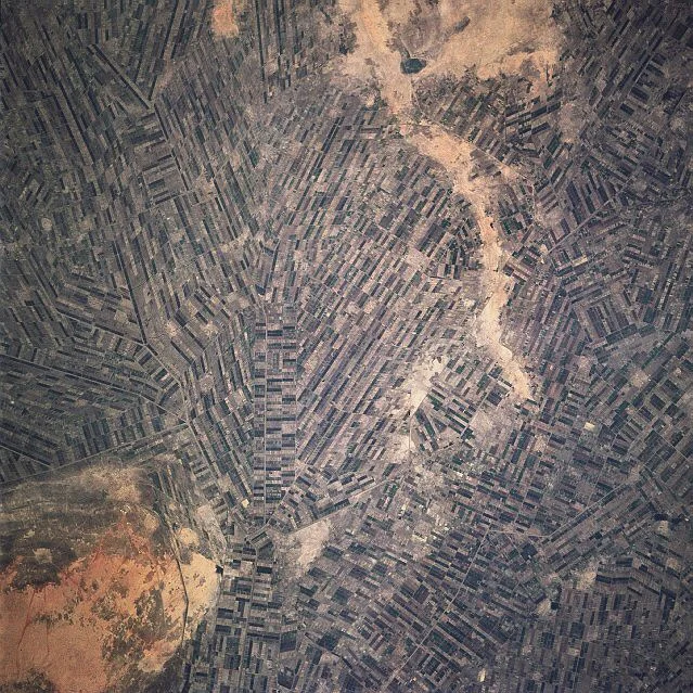
From the Air
Gezira State centers roughly on 14.5 degrees north, 33.5 degrees east, the triangle between the Blue Nile from the east and the White Nile from the west. The state capital Wad Madani is at approximately 14.40 north, 33.52 east, about 180 km southeast of Khartoum. From cruise altitude the Gezira Scheme's geometric irrigation grid is unmistakable, a tan-and-green rectilinear pattern between two Niles. Wad Madani Airport (HSWM) serves the state. Khartoum International (HSSK) is the nearest international option; Port Sudan (HSPN) has been the primary wartime international gateway.
Nearby Stories
- Abushneib 16 km away
- Jebel Moya 86 km away
- Al Qadarif State 98 km away
- Alodia 119 km away
- Soba 128 km away
- El-Gadarif 148 km away
- Kassala 258 km away
- Battle of Shaykan 328 km away