Soba
When Khartoum was founded in 1821, builders needed bricks. They walked twelve miles south along the Blue Nile and took them from Soba. The abandoned city - once the capital of a Christian kingdom that had ruled central Sudan for nine centuries - was still full of red brick stacked in the rough shape of palaces, three churches, and a converted Meroitic temple. Much of what is now the Sudanese capital is built from the architecture of Alodia, which means that walking through downtown Khartoum is a way of walking through a city no one remembers how to pronounce.
The Third Kingdom
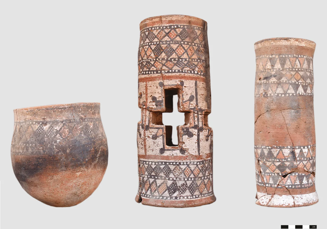
Medieval Nubia, the stretch of the Nile between Aswan and Khartoum, was divided into three Christian kingdoms after the collapse of the old Kushite civilization. The northernmost was Nobadia, capital at Faras. The middle was Makuria, capital at Old Dongola. The southernmost was Alodia - also called Alwa - and its capital was Soba. From roughly the sixth century until around 1500, Alodian kings ruled a territory that included the confluence of the Blue and White Niles and extended well into what is now the Sudanese interior. The Arab geographer Ibn Selim el-Aswani visited in the tenth century and described Soba as large and wealthy, full of fine buildings. Alodia converted to Christianity at about the same time as its neighbors - Orthodox missions arrived from Byzantium in the 540s - and the churches at Soba, built with bricks and narthex-apse layouts, still showed up in twentieth-century excavations as foundations traced in the soil.
A Meroitic Temple Becomes a Church
The site was old before Alodia took it. When the Egyptologist E. A. Wallis Budge identified the Soba ruins in the early twentieth century, he noticed that one of the structures had been a Meroitic temple, built during the era of the Kushite kingdom centered further north at Meroë, and later converted into a Christian church. Continuity of sacred ground: the altar changed, the walls stayed. The city grew to cover approximately 275 hectares at its peak - comparable in footprint to major medieval European cities of the same era. It had quarters with large architectural complexes standing at a distance from one another, and at least one quarter laid out on a visible street grid. Archaeologists still have not identified the royal palace, but the scale of the site makes clear that one existed somewhere in the 275 hectares still mostly unexcavated.
What Ended Alodia
Alodia's end is not well documented, but the rough outline is known. By around 1500, the Christian kingdom had fallen to invading Arabs and their allies, and the Funj Sultanate - an Islamic state based at Sennar - took control of the region. Soba was abandoned. The Blue Nile continued to flow past it. The red-brick walls and the churches and the temple-church stood empty for three centuries while the population moved elsewhere and Islam replaced Christianity as the dominant religion of the central Sudan. When Muhammad Ali's Egyptian forces arrived in 1821 and founded Khartoum at the confluence of the two Niles, the old Alodian capital served a final purpose: as a quarry. Workers dismantled Soba's buildings and floated the bricks downriver. The city that had once held a thousand years of Nubian Christianity became the raw material for a new Ottoman-Egyptian administrative center.
An Archaeology Against the Clock
By the 1990s, a second threat had arrived: the suburbs. Greater Khartoum was expanding southward, and modern buildings began to cover the Soba site. Half of the archaeological zone is now under concrete. The Sudanese National Corporation for Antiquities and Museums, together with the British Institute in Eastern Africa, conducted salvage excavations driven mostly by infrastructure projects - a tarmac road here, new construction there. By 2019, perhaps one percent of the original 275 hectares had been excavated. That year the Polish Centre of Mediterranean Archaeology at the University of Warsaw, together with the Institute of Archaeology and Ethnology of the Polish Academy of Sciences, launched an ambitious long-term project called "Soba - the heart of Alwa," directed by Mariusz Drzewiecki. They have mapped architectural complexes, charted a street grid, and recovered distinctive Soba Ware pottery - but the residence of the Alwa kings is still somewhere under the ground or under the highways.
A Kingdom Beneath the Suburbs
What you see at Soba today depends on what you know to look for. The site sits twelve miles upstream from central Khartoum on the south bank of the Blue Nile. From the ground it can look like empty scrub between new apartment blocks, with the outlines of church foundations picked out in low walls of excavated brick. From the air, in aerial photography, the pattern of ancient streets sometimes surfaces in crop marks. Since the outbreak of the Sudanese civil war in April 2023, the archaeological work has been suspended. What damage has come to the remains during the fighting is not yet known. Alodia - Christian, brick-built, a thousand years long - was a kingdom that mattered in its time and then dissolved. The red bricks of Khartoum are half of the evidence. The ruins on the riverbank are the other half. Between them, a civilization almost no one knows by name once ruled the Blue Nile.
From the Air
Soba lies at 15.524°N, 32.681°E on the south bank of the Blue Nile approximately 12 miles (19 km) upstream from the Blue/White Nile confluence at central Khartoum. From altitude the site is best located by tracking the Blue Nile southeast from the confluence; Soba sits near where the river bends. The archaeological area, now partially covered by suburbs of Greater Khartoum, is not easily distinguished from the built landscape around it. Nearest airport is Khartoum International (HSSS), approximately 10km northwest. In clear weather the river channel and surrounding arid plains provide the primary landmarks.
Nearby Stories
- Esh Shaheinab 27 km away
- Naqa 56 km away
- Mahdist War 65 km away
- Musawwarat es-Sufra 100 km away
- Gezira State 101 km away
- Northern Sudan 215 km away