
Glanfahan
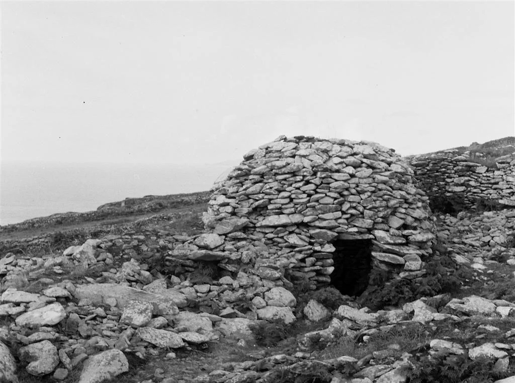
Four hundred and seventeen drystone structures. Nineteen underground passages. Eighteen standing stones. All inside a single townland on the southern slopes of Mount Eagle, looking out over Dingle Bay three kilometres south of Dunquin. Glanfahan is what an abandoned medieval village looks like when nobody comes back to remove the materials. The corbelled beehive huts still stand, some leaning, some half-collapsed, clustered into walled enclosures called cashels. Inside one of them, archaeologists in 2011 found a wrasse tooth - the small grinding tooth of a coastal fish, drilled and polished as an amulet. Someone wore it for luck, then lost it. Most of the rest of the people who lived here have lost themselves too.
An Impossible Census
Counting stone structures in a place like Glanfahan is harder than it sounds. Drystone walls collapse and merge with hillsides. A pile of stones that was once a small clochán becomes indistinguishable from a natural cairn within a few centuries of neglect. Surveyors using aerial photography and ground walking have arrived at 417 recorded structures - hundreds of beehive huts, dozens of larger enclosures, scattered souterrains and standing stones. The density is staggering. For comparison, the entire prehistoric landscape of Skara Brae in Orkney is one village. Glanfahan is more like a dispersed parish, with cashels at the centres and individual huts radiating outward, the whole thing tying together into a kind of vertical village climbing the slope above Dingle Bay.
Dating by Eye
Putting a date on Glanfahan is genuinely hard. The drystone technique used to build the huts has been employed in Ireland from the Neolithic until the twentieth century. Some scholars place the main occupation in the early Christian period, between the 5th and 8th centuries AD, tying the huts to monastic traditions and perhaps to the pilgrimage route that ran from the Dingle Peninsula out to Skellig Michael - the rocky island off the Iveragh coast where monks lived in the 6th century in clocháns of exactly the same design. Other scholars argue for the 12th century, when Norman invaders pushed Gaelic Irish farmers off the better lowlands and onto marginal hills like these. Both could be correct. The same village may have been used, abandoned and reused several times over a thousand years. Some Irish cashels remained inhabited into the 18th century AD.
Cashels and Clocháns
A cashel is a stone-walled enclosure - in effect a ring fort built of stone rather than earth - typically around 20 to 25 metres in diameter. Inside it, smaller drystone huts called clocháns provide the actual living quarters. Glanfahan has several named cashel groups. Caherconner is an oval cashel containing three beehive huts. Cahermurphy is roughly 23 metres across and holds five conjoined clochauns and a sixth irregular structure, all sharing walls. Caherfadaandoruis is an unusual cluster of three conjoined chambers linked by a 23-metre passage. Caheradurras is a triple clochaun. One theory holds that the freemen of the community lived inside the cashels - protected by the heavy outer wall, separated by status - while the unfree lived in single huts outside, exposed to wind and to whatever wolves or raiders the night sent. Whether that hierarchy held is impossible to prove. The architecture allowed for it.
What the Dirt Held
Excavations in 2011 and 2012 under one of the huts called Clochaun 3 turned up the small intimate residue of daily life. There was a sharpening stone for working metal or wood. There was a hammerstone for breaking bones to extract marrow. There were pieces of flint and quartz, flaked into knives and scrapers. The bones included sheep and goats, some with flensing marks where hides had been removed, and fish bones from coastal catches. Most evocative was the wrasse tooth - a small grinding tooth from a wrasse, the brightly-coloured reef fish that schools around the Dingle headlands. The tooth had been drilled and worn as an amulet, a charm against something we cannot name. Bivalve shells and hazelnut shells filled out the picture: a community eating from sea and land, working with stone tools long after stone tools were considered obsolete elsewhere in Europe, hanging fish teeth around their necks for luck.
Damaged in Living Memory
Glanfahan is also a story of slow loss. Many of the archaeological sites here were damaged in the 20th century by what farmers and surveyors politely call agricultural improvements - the clearing of stones, the levelling of mounds, the bulldozing of clochán remains to create flatter pasture. The damage was not malicious. Drystone structures on rough hillside pasture are obstacles to be removed, and for most of the 20th century the protective legislation either did not exist or was poorly enforced on remote land. By the time Glanfahan was given National Monument protection in the latter part of the century, an unknown number of its 417 recorded structures had already been reduced to scatter. The number is impressive. The original number, before the bulldozers, must have been higher still.
The View Out
Walk up through the cashels of Glanfahan on a clear afternoon and the Atlantic opens beneath you. Dingle Bay glitters or growls depending on the wind. To the west, the Blasket Islands rise from the sea in dark humps - inhabited in living memory, abandoned in 1953, now silent. Skellig Michael is too far south to see from here, but it sits at the edge of the same medieval imagination that built these huts. To the north, Mount Eagle rises steeply, the slopes scarred with old field walls. The wind has been working on these stones since before the words for these stones were written down. The huts remain. They will remain for a while longer.
From the Air
Glanfahan sits at 52.101°N, 10.434°W on the southern slopes of Mount Eagle, overlooking Dingle Bay, about 3.1 km south of Dunquin on the Dingle Peninsula. The cluster of stone structures is visible from low altitudes against the green hillsides, especially in raking light when shadows define the circular huts. The nearest airport is Kerry (EIKY) about 47 nautical miles east near Farranfore. For sightseeing, descend below 2,000 feet AGL and follow the coast road south from Dunquin past Slea Head; expect strong westerly winds at this exposed southwestern corner of the peninsula. The Blasket Islands lie just offshore as a striking visual backdrop.
Nearby Stories
- Ballyheigue Castle 1 km away
- Killemlagh Church 2.8 km away
- Pouldergaderry Sinkhole 6.8 km away
- Derreen Garden 11 km away
- Kilkee 59 km away
- The Laki Eruption: The Volcano That Changed World History 1366 km away
- The Northern Lights: The Sky Show That Vikings Thought Was Bridge to the Gods 1469 km away
- Sao Miguel 1935 km away