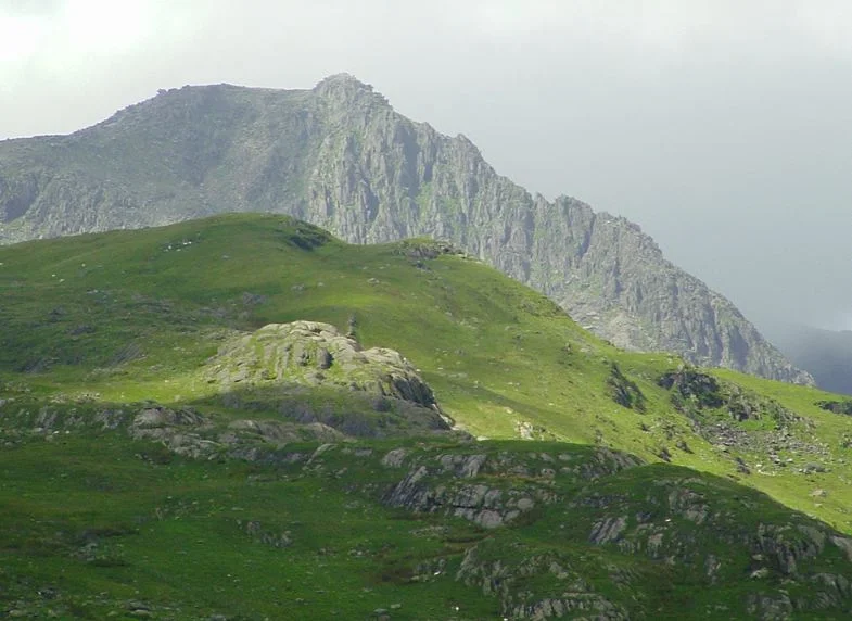

Glyder Fach
There is a slab of rhyolite the size of a small bus, weighing perhaps 25 tonnes, jutting straight out of the summit boulders of Glyder Fach. People walk to the end of it. Some take group photographs. The first time you see somebody do this from the air or from the next ridge over, the response is involuntary - the slab clearly cannot be doing what it is doing. The Welsh called it Y Gwyliwr, "the Sentinel." The English call it the Cantilever Stone. It has been balanced there since the ice retreated, demonstrating that geology does not need engineers to do unlikely things.
The Heap of Stones
Glyder Fach is the second-highest summit in the Glyderau range and the sixth-highest in Wales, reaching 994 metres above sea level. The name itself is a description. According to the medieval Welsh scholar Sir Ifor Williams, "Glyder" comes from the older Welsh "Gludair" - simply, "a heap of stones." That is precisely what the summit is. There is no peak in the usual sense, no single pointed top. Instead, the ridge climbs to an unsorted chaos of fractured volcanic rock dumped there by glacial action and frost shattered into blocks the size of refrigerators and small cars. Walking across the summit area is closer to scrambling on a giant's spilled toy box than to walking on a mountain.
The Cantilever and the Castle of the Winds
Two features dominate the summit zone. Y Gwyliwr - the Cantilever - is a long slab projecting roughly four feet horizontally from a pile of supporting stones near the top. It has been balanced this way since at least the start of the geological present, perhaps 10,000 years; nobody knows exactly when the rock settled into position. A short walk west brings you to Castell y Gwynt, the Castle of the Winds: a jagged outcrop of broken stone that rises from the ridge like a ruined fortification. In winter the Castle is sheathed in rime ice and looks more like its name suggests. In summer it is simply a maze of sharp-edged blocks to be scrambled over or around. Walt Disney's 1981 film Dragonslayer used both features as one of the entrances to the dragon's lair. It is hard to argue with the casting.
Bristly Ridge
The most celebrated approach to the summit from the north is Bristly Ridge - Y Grib Bigog in Welsh, "the bristly crest." It runs up the north face of the mountain from the col below Tryfan. The consensus grading is Scramble Grade 1, but it is at the upper end of that grade; some lines through the Main Gully (also called Dexter Gully) and the direct descent into Great Pinnacle Gap push into Grade 2 territory. Most scramblers take the easier alternatives - Sinister Gully instead of Main, an eastern detour around the Great Pinnacle - and reach the summit plateau without rope or significant exposure. In any weather worse than fair, however, the ridge becomes a serious undertaking; wet rhyolite is treacherous, and the route has claimed lives.
What the Cantilever Has Watched
Climbers know the south face for Flying Buttress, a popular Grade IV route up a steep ridge of grey rhyolite that has been climbed since the 1930s. The whole massif sits between two great glacial valleys - the Llanberis Pass curving to the west and the Ogwen Valley running below to the north - which means Glyder Fach commands views in every direction. Northward to the Carneddau spine. South to the Snowdon massif beyond Crib Goch's serrated profile. West across the strait to Anglesey, sometimes the Wicklow Mountains in Ireland on a clear afternoon. The Cantilever has been watching all of it since the last ice age. A small cottage industry of geomorphologists has examined the stone over the years and confirmed that, yes, it is as precariously balanced as it looks - and yes, it is going to stay that way for the foreseeable future. The strange thing about the summit is not that the stones are arranged this way. The strange thing is that nothing has moved them.
The English Indie Band Connection
There is a final, smaller piece of fame to add to the dragons and the cantilevers. Glyder Fach and its sister peak Glyder Fawr feature in, and provide the setting for, the Half Man Half Biscuit song "Evening Of Swing (Has Been Cancelled)." The Birkenhead band has a long tradition of dropping obscure North Wales place-names into their songs - reasonably enough, since their members grew up looking across the Dee at Snowdonia. The song mentions the mountains by name. There is no swing, evening or otherwise, on the summit. There is mostly wind, and Castell y Gwynt is named for what the wind does there. From the air, in low afternoon light, the shadow of the Cantilever stretches across the boulder field like a long thin finger pointing at nothing in particular.
From the Air
Located at 53.10°N, 4.01°W in the central Glyderau range. The summit reaches 994 m (3,261 ft); maintain minimum FL060 for safe terrain clearance. The Cantilever Stone is visible from low passes south of the summit in clear weather. Bristly Ridge forms the dramatic north face above the Ogwen Valley. Nearest airports: EGCK (Caernarfon Airport) 9 nm WSW, EGOV (RAF Valley) 21 nm WNW. Watch for severe orographic turbulence in westerly flow, cap cloud at or below ridge level in moist airmasses, and persistent leeside rotor in the Ogwen Valley.
Nearby Stories
- Tudweiliog 3.6 km away
- Denbigh Castle and Town Walls 6.4 km away
- Rhoscolyn Lifeboat Station 7.6 km away
- Butlin's Pwllheli 20 km away
- East–West Interconnector 20 km away
- New Brighton Lifeboat Station 31 km away
- Battle of Oswestry 31 km away
- Celtic Array 44 km away