Great Pontal Reserve
On November 25, 1942, Governor Fernando Costa signed decree 13.075 and created an ecological reserve of 246,840 hectares in the westernmost pocket of Sao Paulo state, bounded by two great rivers and protected by statute. Fifty-five years later, in 1997, the reserve was what people called a legal fiction. Most of the trees were gone. The land had been squatted, farmed, and flooded. The decree still existed. The forest did not. Its story is the quiet, painful arc of how a reserve can disappear without ever technically being abolished, and how the process of losing a forest is often just the process of not defending it.
A Reserve Born in a Hurry
Costa had reason to hurry. The Sorocabana Railway had reached the Parana River in 1917, and what followed was the standard frontier pattern: loggers first, then coffee farmers, then cotton and peanuts, then cattle on whatever remained. By 1941, the Morro do Diabo Forest Reserve was already gazetted. A year later came the Lagoa Sao Paulo Reserve. Three weeks after that, the Great Pontal Reserve joined them. Together the three reserves protected 297,340 hectares, a last defense of the Atlantic Forest's interior fragments against a frontier moving west at the speed of a train schedule. For a moment, it looked like the state had drawn a line the market could not cross.
How a Forest Gets Erased on Paper First
The line started dissolving almost immediately. Costa's successor Adhemar de Barros had no interest in the reserves. Local mayors wanted the land for their constituents. In 1944, Adhemar de Barros signed a decree that cut the Great Pontal Reserve by more than half, from 246,840 to 108,900 hectares. The portion he removed was not defended by troops or guards. It was removed by signature. What followed was not a debate but an acceleration. Squatters moved in, some encouraged by state officials, and the chainsaws followed. Between 1945 and 1965, most of what remained was felled to make large cattle farms or small homesteads of five to fifteen alqueires clustered around the new towns. Janio Quadros tried to reverse course in 1955 with new protections. Adhemar de Barros, returning to power, simply repealed them.
The Dam That Swallowed the Rest
In the 1980s, the Companhia Energetica de Sao Paulo began construction on the Engenheiro Sergio Motta Hydroelectric Power Plant, a massive project that would dam the Parana and create a reservoir large enough to be visible from orbit. Law 10.018 of July 2, 1998 formally removed 13,227 hectares of Lagoa Sao Paulo Reserve and 3,211 hectares of Great Pontal from the protected rolls, because those acres were about to be, or already were, underwater. Even the rubber stamps that had eroded the reserve for half a century were now catching up to what the engineers had done. CESP paid indemnities to those who had been living on the flooded land, which meant that people who had squatted on a legally protected reserve for decades were ultimately compensated for the loss of their illegally acquired homes.
What Conservation Looks Like After a Loss
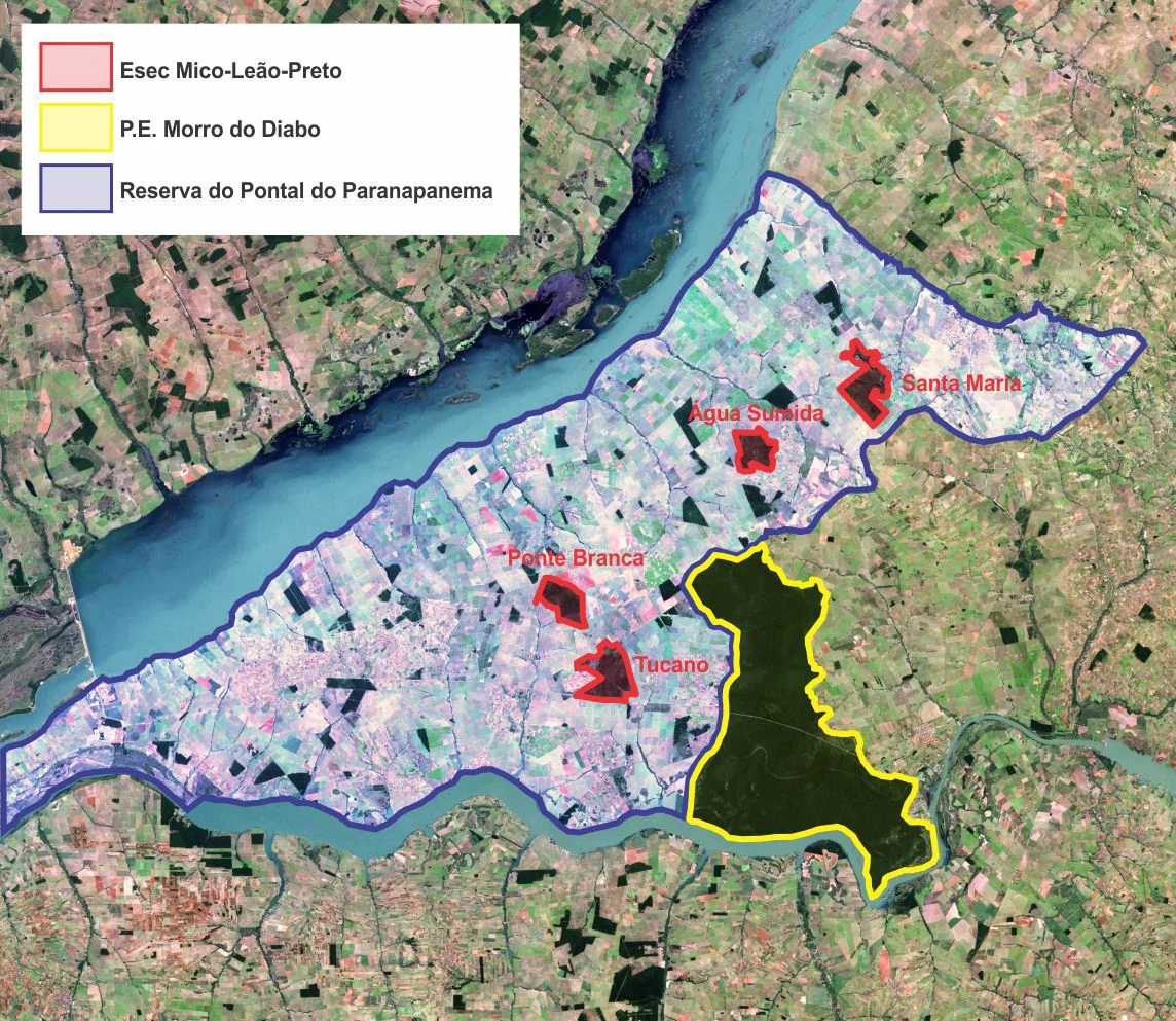
By 1997, the state was negotiating a settlement with the squatters. Give some land back, get clear title to the rest. Three NGOs pushed the government to make sure the land returned to public hands was the forested portion, not the worst-eroded pastureland. The Mico Leao Preto Ecological Station was created by federal decree on July 16, 2002, preserving four separate Atlantic Forest fragments within what had been the Great Pontal. The fragmentation is the point, and the heartbreak. Instead of one contiguous 246,840-hectare reserve, conservation now works through corridors, trying to reconnect isolated pockets of forest through the Atlantic Forest Corridors project. The Institute of Ecological Research, IPE, runs projects in the area: bee farming, tree nurseries, coffee farming on degraded land, studies of the large mammals still hanging on. The black lion tamarin, one of the rarest primates on Earth, survives in tiny remnant patches.
A Poor Land Where a Rich Forest Once Stood
The Pontal do Paranapanema today is the poorest region in the state of Sao Paulo. The cattle pastures and sugarcane fields that replaced the forest do not pay well, because the soil is low in fertility and the distance to markets is long. What was sacrificed for farmland turned out not to be very good farmland at all. The ecological accounting is grim in both directions. The forest that protected watersheds, hosted endemic species, and held carbon is gone. The agricultural economy that replaced it is struggling. It is difficult not to read the whole story as a warning: that reserves cut on paper are gone before the trees fall, and that what looks like the conversion of useless forest into productive land can turn out, on close inspection, to have been the conversion of a great asset into a lesser one.
From the Air
Coordinates: 22.22 degrees south, 52.29 degrees west. Recommended viewing altitude 5,000 to 8,000 feet. The region lies in the extreme west of Sao Paulo state, bounded by the Parana River to the north and west and the Paranapanema River to the south. The closest airport is Presidente Prudente (PPB / SBDN) about 90 km east. The Sergio Motta (Porto Primavera) reservoir dominates the western horizon, a vast artificial lake created by the 1998 damming. Morro do Diabo State Park, visible as a dark block of surviving Atlantic Forest, lies on the southern edge of the old reserve area.
Nearby Stories
- Presidente Prudente 32 km away
- Lagoa São Paulo Reserve 41 km away
- Nova Andradina 63 km away
- Tietê River 150 km away
- Guaira Falls 236 km away
- Campo Grande 257 km away
- Vila Velha State Park 349 km away
- Battle of Cerro Cora 392 km away