Tietê River
The name is older than the mapmakers. When d'Anville put it on a map in 1748, Tietê was already what the Tupi-speaking people had called it for centuries: truthful river, truthful waters. For most of its 450 kilometers across São Paulo state, the Tietê still moves barges and freight, still passes under tourist boats at Barra Bonita, still hosts rowing clubs whose boathouses have stood since the 1920s. But the stretch inside São Paulo city tells a different story. National Geographic called the Tietê the most polluted river in Brazil in September 2010, and despite decades of cleanup work the stretch through the capital still runs dark with foam and the smell of industrial failure.
From the Serra to the Sea
The Tietê's headwaters rise in the Serra do Mar east of São Paulo city, at Salesópolis, where water flows over stones to begin the long westward run. One of Brazil's first hydroelectric stations - Usina Parque de Salesópolis - was built here in 1912 by the São Paulo Tramway, Light and Power Company, a Canadian firm. The plant generated power from a 72-meter water drop through a pair of surface pipes, with a dam just 5 meters tall built at the lip of a waterfall. From Salesópolis the river works its way westward through the Paulistana metropolitan area and then out across the interior, gathering water from tributaries that include the Piracicaba, the Sorocaba, and the Jundiaí.
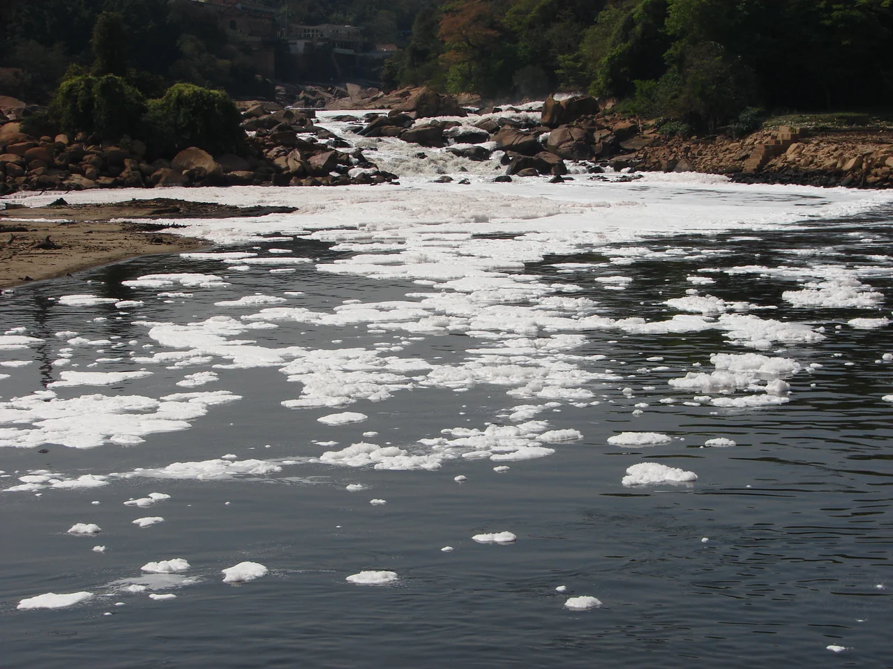
Truthful Waters, Troubled Water
The Tietê's degradation did not arrive all at once. In the 1960s, the stretch of river inside São Paulo city still held fish. Rowing regattas had been major events in the 1920s and 1930s - boat clubs like Espéria and the Tietê Rowing Club (Clube de Regatas Tietê) lined the banks. The trouble started subtly in the 1920s, when the São Paulo Tramway, Light and Power Company built the Guarapiranga Reservoir and began rectification works between Vila Maria and Freguesia do Ó, straightening the river and altering its natural regime. Industrial growth and sewage overwhelmed the channel. By the time National Geographic ran its 2010 feature, photographs of foam chokingly piled on the surface had become the river's most recognizable image.
The Cleanup Grind
The governor of São Paulo ordered Sabesp - the state sanitation company - to establish a cleanup program, and the state sought help from the Inter-American Development Bank. The Tietê Project has now run more than sixteen years. Progress is visible if incomplete. By the late 1990s, Sabesp had expanded treatment capacity at the Barueri Wastewater Treatment Plant and the San Miguel sewage treatment facilities. Oxygen levels in the worst stretches have risen. Fish have returned to some upstream sections. But several species remain threatened, and the catfish Heptapterus multiradiatus is possibly already extinct. Restoring a river gutted by nearly a century of industrial growth turns out to be harder than damaging it.
The Inland Waterway
Away from the city, the river does real economic work. The Tietê-Paraná waterway permits navigation across 1,100 kilometers between Conchas (on the Tietê) and São Simão (on the Paranaíba), extending another 1,300 kilometers up to Itaipu for a total of 2,400 kilometers of navigable inland water. Several dams - Barra Bonita among them - include ship locks that allow barges to transit. More than one million metric tons of maize alone moves each year along this system, with total freight - including sand, gravel, sugarcane - around 2 million tons annually, traveling an average 700 kilometers. The cost per ton-kilometer runs substantially below road transport, and the waterway connects interior Brazil to the port of Santos.
Boat Races and Paintings
The cultural memory of the Tietê runs deep. Almeida Júnior's 1897 oil painting Study for "Departure of the Monção" records a nineteenth-century river expedition departing from the Port of Araritaguaba (now Porto Feliz) - an echo of the monçõezinhas, the small seasonal flotillas that used the Tietê and its tributaries to push inland toward the gold fields of Mato Grosso. The boat race clubs that emerged along its banks in the 1920s - the Clube de Regatas Tietê and Espéria - still exist, though their members mostly train in protected pools these days rather than in the river itself. The Marginal Tietê - the giant expressway that parallels the river through São Paulo city - takes its name from the water it accompanies, though few of the commuters stuck in its traffic would think of themselves as driving along truthful waters.
A River Reading
From the air the Tietê reads like a long dark arc across São Paulo state. Near its source in the Serra do Mar east of the capital, it appears as a narrow tropical stream winding through forested hills. Through the São Paulo metropolitan area, it becomes the brown-gray ribbon along the Marginal Tietê expressway, flanked by industrial zones and dense urban neighborhoods. Past Pirapora do Bom Jesus, it widens into a working agricultural and freight corridor, threading past Tietê and Barra Bonita, where tourists sometimes take dinner cruises across the reservoir. Salto marks the famous 12-meter waterfall that once gave the town its name. By the time the Tietê joins the Paraná River at the western edge of São Paulo state, it has been many rivers - truthful to some, deeply wronged by others, and still moving.
From the Air
The Tietê River extends approximately 1,100 km across São Paulo state, with headwaters near Salesópolis (east of São Paulo city in the Serra do Mar at ~1,000m elevation) flowing generally westward to join the Paraná River. Central reference point: approximately 20.63°S, 51.57°W. The river threads through the São Paulo metropolitan area (visible along Marginal Tietê expressway corridor) then runs northwest past Barra Bonita, Jaú, and Aguas de Santa Bárbara. Reservoirs including Barra Bonita form visible widenings. Major airports along the corridor: Guarulhos (SBGR), Viracopos Campinas (SBKP), Bauru (SBAE), Araçatuba (SBAU). Recommended viewing altitude: 8,000-12,000 feet AGL for river course segments.
Nearby Stories
- Cisalpina Private Natural Heritage Reserve 55 km away
- Paraná River 63 km away
- Birigui 78 km away
- Votuporanga 108 km away
- Great Pontal Reserve 147 km away
- São Simão, Goiás 162 km away
- Nova Andradina 222 km away
- Mato Grosso do Sul 279 km away