Paraná River
In Guarani, para means sea and parana is a cousin word, loosely translatable as "kin of the sea" or simply "great water." Linguists have long since discounted the more poetic interpretations, but the name keeps appearing across South America in dozens of river names. The Paraná is the largest of them. It flows 4,880 kilometers from central-southern Brazil to the Rio de la Plata, passing through Paraguay and Argentina along the way, and is second in length only to the Amazon. When Venetian explorer Sebastian Cabot became the first European to sail up the Paraná in 1526, working under the Spanish crown, he was entering a waterway whose dimensions he could not have measured. Modern data keeps humbling that first reconnaissance. Atlantic outflow through the Paraná's eventual delta roughly equals the Mississippi's.
A Confluence of Giants
The river does not begin at a single spring. It forms at the confluence of two Brazilian rivers, the Paranaiba and the Rio Grande, at a border point shared by São Paulo, Minas Gerais, and Mato Grosso do Sul states. From that triple junction the combined water flows southwest for 619 kilometers, heading toward Paraguay. The Paranaiba contributes the larger share, rising in the Mata da Corda mountains at 1,148 meters elevation. The Rio Grande comes from the Mantiqueira range. When they meet, the new river takes the name Paraná and begins the work of draining a large share of south-central South America. The drainage basin covers all of Paraguay, much of southern Brazil, northern Argentina, southeastern Bolivia, and, if you count the Uruguay as a tributary, most of Uruguay as well. This is water in industrial quantities.
The Lost Falls
The Paraná once had a waterfall that, by contemporary accounts, rivaled Iguazu to the south. The Guaira Falls, also called the Sete Quedas or Seven Falls, dropped the river over a series of seven cascades at what is now Saltos del Guaira, Paraguay. The Iguazu can still be visited. The Guaira cannot. In 1982, the reservoir behind the Itaipu Dam flooded the cascades. Itaipu stands as the world's third-largest hydroelectric plant today, behind only the Three Gorges and Baihetan Dams, both in China. Along with the Yacyreta Dam upstream on the Argentina-Paraguay border, Itaipu has made Paraguay the world's largest exporter of hydroelectric power. The exchange was explicit. The country lost a natural wonder that would have drawn international tourism and gained an energy industry that sustains its economy. The Paraná is no longer continuously navigable through its upper stretches, but the water still runs.
Cities Along the Line
The river becomes a border before it becomes a delta. After the Iguazu meets the Paraná, the combined flow separates Paraguay from Argentina for hundreds of kilometers. Encarnacion, Paraguay, looks across to Posadas, Argentina. Further south, after the Paraná accepts its largest tributary, the Paraguay River, it turns west for 820 kilometers before curving back east at Rosario in Argentina. The final 500 kilometers head to the Uruguay River and the Rio de la Plata. The Paraná delta begins downstream from Diamante, Entre Rios, where the water splits into several arms and spreads across a dramatic floodplain. São Paulo, Buenos Aires, Asuncion, Brasilia, Rosario, and La Plata all lie within the Paraná watershed, which means that when the river droughts, as it did in 2021 reaching a 77-year low, the consequences ripple across three countries.
Fish, Birds, and Bridges
The Paraná delta ranks among the world's greatest bird-watching destinations. The river itself sustains important commercial fisheries built around species like the surubi, a big catfish that rewards patient anglers, and the sabalo, a migratory fish harvested in quantities large enough to support both local consumption and export. Fishermen have lived along the banks for centuries, and many still do. Navigation is another matter. Paraguay and Argentina argued through the 1960s over navigation rights and the construction of bridges across the river. Paraguay held out. The two countries eventually signed a navigation-rights agreement in January 1973, endorsing free passage on the river and requiring each nation to treat the other's vessels as its own. The same year, construction began on Itaipu. A century-long infrastructure project was just getting started, and the Paraná would be remade to serve it.
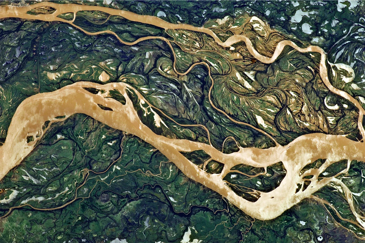
From the Air
The Paraná River is one of the most prominent water features visible from cruising altitude over south-central South America. Representative coordinate for the middle upper course is 20.09 degrees south, 51.00 degrees west, where the river borders São Paulo state and Mato Grosso do Sul. From altitude the river's scale becomes apparent: a broad, frequently braided channel punctuated by reservoirs behind major dams (Itaipu, Yacyreta, and upstream structures). The Iguazu confluence forms one of the most recognizable water landmarks in South America. Major airports in the watershed include São Paulo's Guarulhos (SBGR), Asuncion (SGAS), and Rosario (SAAR).
Nearby Stories
- Tietê River 50 km away
- Votuporanga 68 km away
- Cisalpina Private Natural Heritage Reserve 96 km away
- São Simão, Goiás 97 km away
- Birigui 133 km away
- Quirinópolis 174 km away
- Lagoa São Paulo Reserve 176 km away
- Jataí 221 km away