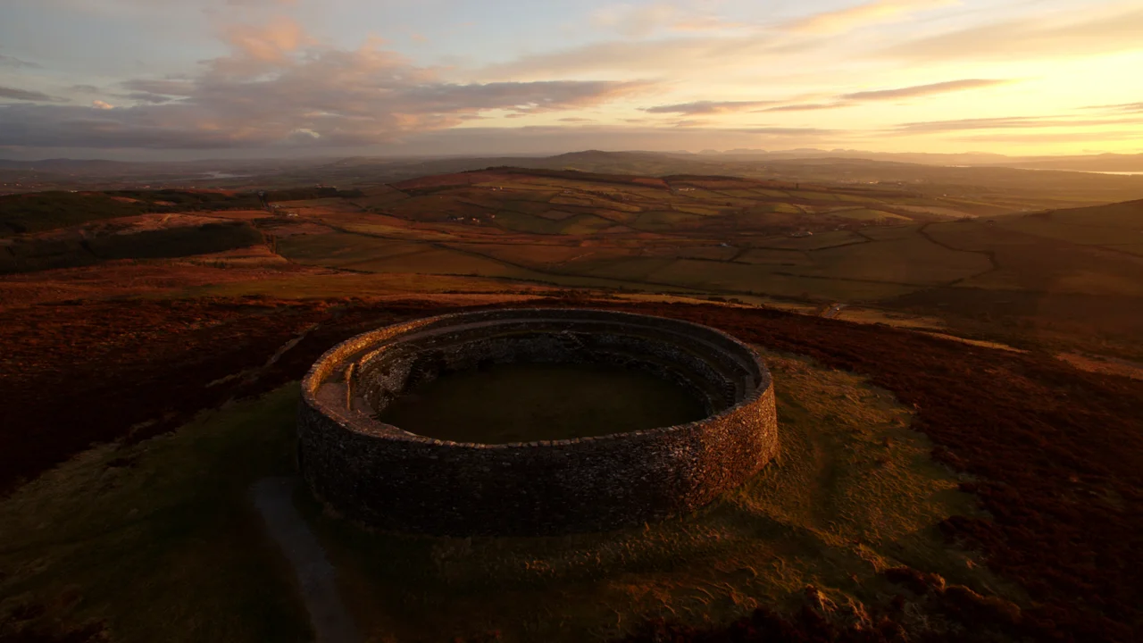

Grianan of Aileach
In 1101, Muirchertach Ua Briain, king of Munster, marched into the Inishowen peninsula and gave his army an order so vivid the chronicles still record it: every soldier was to carry a single stone from the Grianan of Aileach back to his home in Munster. The vengeance was personal. Domnall Ua Lochlainn had destroyed the Munster royal seat at Kincora thirteen years earlier, and Muirchertach wanted the symbolic equivalent. He nearly got it. The walls came down. The royal capital of the northern Ui Neill - the dynasty descended from Niall of the Nine Hostages - was gutted, and the kings who had ruled from this hilltop for three centuries lost the visible symbol of their authority. The fort that stands today is mostly a Victorian reimagining, built between 1874 and 1878 by a Derry antiquarian working partly from imagination. The view, however, has not changed at all.
The Stone Palace of the Sunny View
Grianan means a sunny place, or a place with a view. Aileach probably derives from ail, the old Irish word for rock or boulder - so the full name renders roughly as the Stone Palace of the Sunny View. Both halves are accurate. The fort sits 244 metres above sea level on Greenan Mountain at Burt, on the western edge of a small group of hills between the upper reaches of Lough Swilly and Lough Foyle. From the summit you can see across the borders of three modern counties - Donegal, Tyrone, and Londonderry. The hill itself is not particularly tall. What makes the position commanding is its isolation, its panoramic view, and the way it sits at the geographical pivot of a kingdom that controlled trade and political power across northwest Ireland. Inside the cashel - the circular stone wall, about 23 metres across - three terraces ascend, linked by stairs. Two passages run inside the wall, apparently to nowhere, their original purpose still debated.
Royal Capital
From the middle of the sixth century until 1101, the Grianan of Aileach served as the capital of the northern Ui Neill. The Tripartite Life of St Patrick records that Patrick blessed the fortress and left a symbolic flagstone, prophesying that many kings and clerics would come from the place. The flagstone is gone, possibly preserved at Belmont House School in Derry as St Columb's Stone, with two feet marks carved on its 2-metre face. The annals report attacks. In 674, Finsnechta Fledach, king of Ireland, destroyed an earlier hillfort on the site - possibly the prehistoric earthworks whose remains still surround the cashel. In 937, Viking raiders demolished it during the reign of Muirchertach mac Neill. In 1006, Brian Boru himself marched through the territory of the Cenel Conail and the Cenel Eogain on a tour of his kingdom. After 1101, the kings of Aileach were kings in name only - the capital was a ruin, the political world had shifted, and the dynasty was negotiating a different Ireland.
Bernard's Reconstruction
By the 1830s, when the Irish antiquarian George Petrie surveyed the site, the cashel had collapsed to a mere ruin standing perhaps 1.8 metres high. Walter Bernard, a Derry doctor, undertook the reconstruction between 1874 and 1878. Bernard faced a problem: he did not have a model. The Grianan was unusual - a multivallate hillfort cashel in a region of Ireland with very few such structures - and Bernard concluded that he would have to look elsewhere for guidance on what the original might have looked like. He chose Staigue Fort in County Kerry, hundreds of miles away in the southwest. From Staigue, Bernard derived the architecture, the proportions, the terraces, much of the visible character of the reconstructed cashel. Whether the actual ancient builders in Donegal had ever built anything like Staigue Fort is impossible to know now. The reconstruction was poorly engineered: within thirty years of state custody, parts of it were crumbling again. What stands today is Bernard's best guess at what an antiquarian thought a Donegal hillfort ought to look like, perched on stones that genuinely are old.
Mass Rock and Megalith
Even after its destruction, the Grianan refused to be merely ruined. During the centuries of anti-Catholic persecution that ran from Henry VIII to Catholic Emancipation in 1829, the Grianan served as a Mass rock - a place where outlawed Catholics could gather to celebrate the liturgy in defiance of the Penal Laws. The penal church Petrie recorded inside the cashel, with walls of mortar barely 62 centimetres high, may date from this era. Outside the walls, on the south side of the hill between two outer banks, sits St Patrick's Well - a covered spring that ties the site to the saint who, according to legend, blessed the fortress. A tumulus, possibly Neolithic, sits between the second and third ramparts: a mound of stones whose meaning was lost long before Petrie's survey. The Grianan now operates as a national monument, a tourist attraction with a small car park and an interpretive sign. Tour groups arrive year-round. The sunset views, when the cloud cooperates, still justify the old name. The Stone Palace of the Sunny View has outlasted its kings.
From the Air
Coordinates 55.02 degrees N, 7.43 degrees W, atop Greenan Mountain at 244 metres elevation, on the southern Inishowen Peninsula in County Donegal. Best viewed at 3,000 to 5,000 feet AGL for the dramatic hilltop circular form and the dual loughs (Swilly to the west, Foyle to the east). The fort is 11.25 km northwest of Derry. Nearest airport is City of Derry Airport (EGAE) about 12 km east, often within easy visual range. Donegal Airport (EIDL) sits roughly 60 km west. Coastal weather can be very changeable; clear conditions reveal a famously panoramic view across three counties.
Nearby Stories
- Donegal Castle 2.2 km away
- Greencastle, County Donegal 3.1 km away
- Dungiven 6.8 km away
- Dunaff 9.7 km away
- Tory Island 12 km away
- Omagh 18 km away
- Gweedore 19 km away
- Castlecaulfield 22 km away