IJssel
For centuries the story went like this: around 12 BCE, Roman legionaries under the general Nero Claudius Drusus picked up shovels and dug a connection between the Rhine and a small local river called the Issel. The intent was military - a quick way to move troops north against Germanic tribes - but the consequence was hydrological, and the IJssel, as it would come to be called, became a Roman engineering project. Modern geology has complicated that legend. Radiocarbon evidence from Wageningen University suggests the IJssel only became a significant Rhine distributary around 600-950 AD, through a natural breakthrough - an avulsion - rather than a Roman canal. But the legend persists, because it is a good story, and because the Roman dug a canal somewhere in this delta, even if it wasn't quite this one.
A River With Two Capital Letters
Even the name is strange. IJ is a digraph in Dutch orthography, treated as a single letter, which is why both characters get capitalised together - IJssel, not Ijssel, just as in IJmuiden and IJsselmeer. The river itself bears at least three layers of naming. The Romans called it Isala. Old Dutch documents from 797 and 814 AD record it as Hisla. Over centuries the h dropped, vowels shifted, and Ysola, Ysla, Isla and finally IJssel emerged. The root probably comes from a Proto-Indo-European word eis, meaning to move quickly - the same root that gave Old Norse its word for racing forward and Latin its word for anger. A river that moves with energy. The IJssel does not look it today, sliding placidly between dykes, but the name is older than the placidity.
How a Roman Canal Becomes a Lifeline
Drusus's canal turned a small headstream - the river now called the Oude IJssel, which still rises near Borken in Germany - into the upper reach of a much larger waterway. Once Rhine water was pouring north, the IJssel had enough discharge to become navigable. Average flow today is around 300 cubic metres per second, though it can drop to 140 or surge to 1,800 depending on Rhine conditions and the weirs west of Arnhem that control the inflow at the Pannerdens Kanaal. Along the river's 125 kilometres of meanders - originally 146 km before nineteenth-century engineers cut off some bends - the IJssel passes through and built up most of the Hanseatic towns of the eastern Netherlands. Arnhem at its start, then Doesburg, Zutphen, Deventer, Zwolle, and finally Kampen at the delta. Each was a port. Each was rich. None of them would exist in their current form without Drusus's spade work.
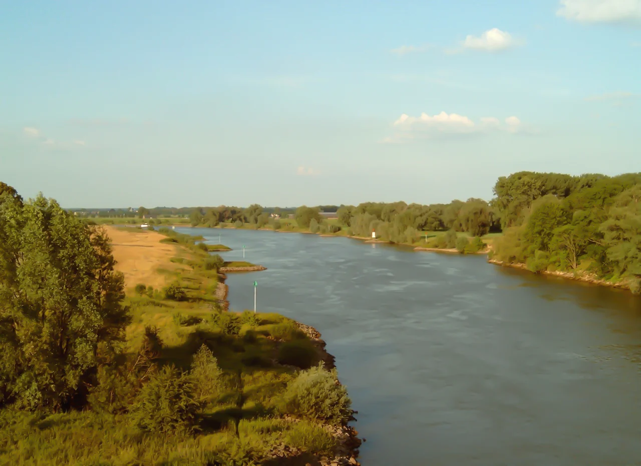
The Slow Country
Watch the IJssel from a dyke for half an hour and you understand why the Dutch landscape painters loved it. The current is slow enough to be almost imperceptible. The banks are flat, the meadows behind them flatter, and the horizon is broken only by church spires and the occasional wind turbine. Cattle graze on the floodplains in summer. In winter the water rises and the polders behind the dykes do their job - lying ready to be flooded if necessary, so that the cities behind them stay dry. Hendrick Avercamp painted skaters on a frozen IJssel near Kampen around 1625. The painting still looks accurate, allowing for fewer skaters and warmer winters.
Where the River Comes Apart
In its last few kilometres, near Kampen, the IJssel splits into a small delta of distributaries - the Keteldiep, Kattendiep, Ganzendiep and Goot, with a fifth, the Noorddiep, now dammed at both ends. Once the river had many more mouths, but most have been silted up, dammed off or rerouted to control flooding. Before 1932 these channels emptied into the salty Zuiderzee, and northwesterly gales would push seawater back up the delta, drowning farms and fields. Then came the Afsluitdijk - the great 32-km barrier across the mouth of the Zuiderzee - and the body of water beyond Kampen became the freshwater IJsselmeer instead. The IJssel went from being a tidal estuary to being the main feeder of an inland lake. Most of the surrounding land - Flevoland, the Noordoostpolder, the polder south of Dronten - was then reclaimed from the lake itself, six metres below sea level, on what had been the IJssel's submerged old delta.
A River in War
In April 1945 the IJssel became, briefly, one of the last natural defences of the German occupation of the Netherlands. Allied troops liberating the eastern Netherlands had to force crossings under fire all along the river. The assault was successful - the IJssel was breached, the eastern provinces freed - but the river bears the memory in the form of bridges that were destroyed and rebuilt, and the liberation memorials that stand in the riverside cities. It is a quiet river now, with road crossings at Arnhem, Doesburg, Zutphen, Deventer, Zwolle and Kampen, and cable ferries still operating at a handful of small villages where building a bridge would be excessive.
The Province That Took Its Name
On a map the IJssel separates the province of Gelderland from the province of Overijssel - literally Over-IJssel, the province across the river, as seen from the Bishop of Utrecht who once held the territory. The river named a province. It also gave its name to the IJsselmeer it now flows into. Few rivers in Europe have left this much linguistic trail behind them. For a waterway that began as a Roman shortcut, the IJssel has done remarkably well at being remembered.
From the Air
The IJssel runs roughly 125 km between Westervoort (52.0 N, 6.0 E, just east of Arnhem) and its mouth at Kampen (52.55 N, 5.92 E). From cruise the river is a clearly visible meandering ribbon through eastern Netherlands lowlands, with major Hanseatic cities strung along its length: Arnhem, Doesburg, Zutphen, Deventer, Zwolle, Kampen. The current article point at 52.5828 N, 5.84 E sits at the mouth, where the river enters the freshwater IJsselmeer. Nearby airports include Lelystad (EHLE) about 15 km west, Teuge (EHTE) further south, and Schiphol (EHAM) roughly 70 km west. Best viewed at 3,000-6,000 ft in late afternoon when low sun catches the bends.
Nearby Stories
- Round House (Nunspeet, Netherlands) 2.6 km away
- Almere 3.3 km away
- Pinksterlanddagen 4.7 km away
- Joure 6.1 km away
- Bovenkarspel 6.2 km away
- Sallandse Heuvelrug National Park 8.2 km away
- Hoogeveen 12 km away
- Afsluitdijk 12 km away