Ipubi Formation
The layer is only about fifteen meters thick, pressed between two thicker rock formations that get all the attention. Geologists call the Ipubi Formation the middle child of the Santana Group - less famous than the fossil-rich Crato beneath it and less dramatic than the Romualdo above, which captured sharks and pterosaurs in stone. But what Ipubi records is something stranger than any single creature. Over a few million years in the Early Cretaceous, an ancient lake in what is now northeastern Brazil dried and flooded and dried again, each cycle leaving behind shale and gypsum like pages in a notebook. The Atlantic Ocean had not yet opened here. When it did, Ipubi was the threshold.
Rift in a Young World
To understand Ipubi, you have to picture a Brazil that no longer exists. Around 120 million years ago, South America was still pulling away from Africa, and the rift between them ran diagonally across what would become the Borborema Province. The Araripe Basin formed as part of that splitting, a long trough in the crust where rivers drained and lakes gathered. The basin moved through five distinct stages - quiet subsidence in the Silurian, the mechanical stretching that preceded the full rift, the graben collapse of the Berriasian, and finally the thermal sag of the Aptian and Albian. Each stage left its own rock signature. By the time Ipubi began to form, the violent tectonic work was done. What remained was a broad lake in a warm, increasingly arid land, fed by seasonal rains and bounded by basement highs that had not yet broken.
A Lake That Kept Score
Palynologists reading the fossilized pollen of Ipubi describe a tropical arid to semiarid world of conifers, gnetaleans, bennettitaleans, and the very first flowering plants - angiosperms in their opening act. The lake itself cycled between freshwater and brackish, between oxygen-rich and oxygen-starved. When water was deep, dead algae and bacteria sank into an anoxic bottom where nothing could decompose them, and the sediment swallowed their carbon whole. The black, organic-rich shales that formed during those wetter intervals now carry high concentrations of total organic carbon - enough that geologists identify Ipubi as a potential shale gas target. When the lake shallowed, evaporation concentrated the brines, and gypsum and anhydrite precipitated in sheets and nodules. Read in sequence, the formation is a climate record written in chemistry.
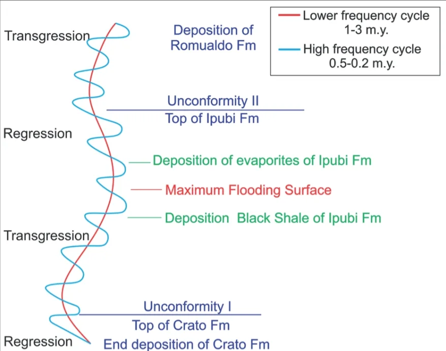
The Missing Fossils
The Crato Formation below Ipubi is one of the great fossil lagerstatten of South America - pterosaurs with wing membranes preserved, insects with wing venation intact, fish frozen mid-swim. The Romualdo above it captured sharks and turtles and the bizarre pterosaur Tupandactylus. Ipubi, pressed between them, is strangely quiet. Almost no vertebrates. A single side-necked turtle, catalogued as CPCA 3560 - a crushed skull, a fragment of jaw, a piece of carapace - is the best fossil the formation has yielded. Ribeiro Oliveira and colleagues described it in 2011 and could not assign it confidently to a genus. Fielding and his team in 2005 had tentatively called it Araripemys. The silence is its own evidence. Water too salty, bottoms too anoxic - the lake had become a place where little could live, and fewer things died in a way that preserved them.
The Sea Comes In
What ended Ipubi was a rising Atlantic. As the post-rift sag continued, a relative sea level rise during the Albian pushed marine waters inland across the Borborema Province, creating a shallow seaway that connected South America's interior to the proto-Atlantic. The evaporites of Ipubi were exposed, eroded, partly dissolved - their upper surface karstified into a ruiniform landscape of depressions and sinkholes before the transgression buried everything beneath the calcareous shales and sandstones of the Romualdo Formation. The marine fossils tell the rest. Sharks and rays in the Romualdo record waters that had simply not been there before. Ipubi marks the threshold - the last inland lake before the ocean arrived.
Reading Rock as Text
From the air above Araripe today, the formation is visible as pale bands in the escarpments around Nova Olinda and Santana do Cariri. Gypsum mines work the evaporite layer for construction plaster, cutting into rock that was once lake bottom. The shales are dark, almost black, and split along laminations so fine they preserve the cycling of anoxic and oxic conditions at the scale of a thumbnail. Geologists have identified six stages in the depositional cycle - pulsating expansion, subaerial exposure, transgression, highstand with evaporites, regression and karstification, and the final marine flooding. It is a tidy story told in layers, and it remains the clearest record anywhere of the moment when Brazil's interior stopped being a lake country and became, briefly, a continental sea.
From the Air
Approximate coordinates 5.6 degrees south, 64.3 degrees west, in the Amazonas interior where the formation extends westward from its Araripe Basin type locality in northeastern Brazil. Cruising altitudes of 10,000 to 20,000 feet offer broad views of the Cretaceous rock terrain. Nearest major airports are Manaus (SBEG) to the north and Porto Velho (SBPV) to the southwest. Expect tropical convection and afternoon thunderstorms during the wet season from December through April.
Nearby Stories
- Amazonas (Brazil) 76 km away
- Nascentes do Lago Jari National Park 118 km away
- Amazonas (Brazilian state) 153 km away
- Juruá-Purus Moist Forests 191 km away
- Humaita National Forest 201 km away
- Medio Purus Extractive Reserve 228 km away
- Tefe 243 km away
- Ituxi Extractive Reserve 257 km away