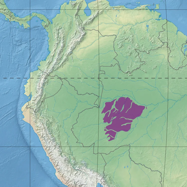
Juruá-Purus Moist Forests
The rivers are barriers here, not just passages. On one side of the Purus River, some species of primate live. On the other, subtly different subspecies of the same genus have evolved in isolation. Insects do the same thing. The rivers of the Juruá-Purus moist forests are wide enough and old enough that animals that cannot swim or fly have been separated into slightly different genetic trajectories by water. This is what it means for a place to be large and inaccessible and uninterrupted: the natural processes of speciation run to their conclusion in ways that are more difficult to observe anywhere else in the tropics. The ecoregion covers 242,681 square kilometers. No roads cross it. Not yet.
Flat and Flooded
The ecoregion sits in the low Amazon basin at elevations between 20 meters and a few dozen meters above sea level. The terrain is flat - truly flat, with the kind of minor relief that makes even small variations in elevation hydrologically significant. Large meandering rivers thread through the plains, carving oxbow lakes where their loops have been cut off, joined by thousands of smaller tributaries. All of them flood annually. The sediments are late Tertiary in age - young rocks, easily eroded - and the rivers they feed are whitewater systems carrying mineral and organic solids downstream. Soils include sandy podzols and hydromorphic clays, typically acidic and low in nutrients. What grows here has to deal with seasonal inundation and with ground that cycles nutrients slowly when it cycles them at all.
A Forest of 250 Species per Hectare
Near the town of Carauari, researchers counting tree species per hectare have logged 250. That number is high even for the Amazon. The Juruá-Purus supports more than 60 species in the Sapotaceae family alone - trees related to the sapote and the star apple, mostly canopy and understory dwellers. The dominant families are the same that dominate most of the Amazon: Fabaceae, Sapotaceae, Lecythidaceae, Moraceae, Chrysobalanaceae, Lauraceae, Myristicaceae. But within that framework, diversification runs deep. The canopy sits around 30 meters with emergents to 45. Most trees have trunks less than 30 centimeters wide, and a few giants - Cariniana decandra, Osteophloem platyspermum, Piptadenia suaveolens, species in Brosimum, Eschweilera blanchetiana, Sclerobium paraense - reach 240 centimeters. Four common palms work the understory: Astrocaryum vulgare, Oenocarpus bataua, Attalea maripa, Socratea exorrhiza.
Primates Divided by Water
The rivers as barriers have produced some of the ecoregion's most distinctive fauna. Over 170 species of mammals live here. Almost 120 species alone have been recorded at one location on the upper Urucu River. Mammals that can traverse between flooded and terra firme forests include the common squirrel monkey, white-fronted capuchin, brown woolly monkey, and collared peccary. Species restricted to the Southwestern Amazon Moist Forests global ecoregion include the short-eared dog - a rare canid seldom seen by researchers - Linnaeus's two-toed sloth, the pygmy marmoset, brown-mantled tamarin, and Goeldi's marmoset. The endangered Peruvian spider monkey and giant otter hold out in the less-disturbed stretches. Large mammals include silky and southern and giant anteaters, the brown-throated sloth, jaguar, cougar, two species of brocket deer, and the South American tapir.
Birds and the Curassow Question
Over 550 species of birds have been recorded in the ecoregion, with many endemics. The mix includes macaws, parrots, and tanagers in their familiar Amazonian abundance - species in Amazona and Ara, genera like Tangara and Tachyphonus. The seasonal migrants come through. The non-migratory residents include the pavonine quetzal, with its iridescent green plumage, and three species of curassow - the nocturnal, the razor-billed, and the wattled - whose declines track the declines of intact forest everywhere. Crax globulosa, the wattled curassow, is endangered, its populations pushed back by hunting and logging. Tinamous - ground-dwelling birds related to ratites - creep through the understory in genera Crypturellus and Tinamus. The white-throated toucan and the various woodcreepers move through the canopy. The full avifauna has not yet been exhaustively surveyed.
What Has Not Happened Yet
The World Wildlife Fund classes the ecoregion as Relatively Stable and Intact, a phrase that understates the contingency of the situation. No roads cross the Juruá-Purus. That is the primary reason it remains forest. Petrobras has explored for oil and gas here for years and cut deforested patches. A large area near Tefé was cleared for an experimental agricultural project that was abandoned and is now secondary forest. Urban centers - Carauari, Tefé, Coari, Jutaí - and small farming settlements along the rivers are surrounded by clearings for houses, agriculture, and pasture. Hunting and selective logging reach further into the forest than any road does. The large threat is a planned extension of the Trans-Amazonian Highway from Lábrea on the Purus to Tabatinga on the triple border with Peru and Colombia. If that highway is built, the forest along it changes. That is what roads do. The Juruá-Purus is what Amazonia looks like before the road arrives.
From the Air
Centered at 4.88 degrees south, 66.36 degrees west in the state of Amazonas in northwest Brazil. Cruising altitudes of 15,000 to 25,000 feet show the flat floodplain landscape cut by the meandering Juruá, Purus, Jutaí, Tefé, and Tapauá rivers, with innumerable oxbow lakes catching light. Nearest airports are Tefé (SBTF) on the Solimões, Eirunepé (SBEP) on the Juruá, and Labrea (SBLB) on the Purus. Expect heavy afternoon convection year-round with peak storm activity in the March-to-June wet season.
Nearby Stories
- Amazonas (Brazilian state) 139 km away
- Ipubi Formation 169 km away
- Santana Group 181 km away
- Central Amazon Ecological Corridor 186 km away
- Tefe 220 km away
- Tonantins 245 km away
- Cujubim Sustainable Development Reserve 261 km away
- Medio Purus Extractive Reserve 265 km away