Central Amazon Ecological Corridor
Protected areas do not work as islands. Conservation biologists learned this the hard way. A national park surrounded by deforestation slowly loses its species to genetic isolation, edge effects, and the simple arithmetic of shrinking habitat. By the time the first agreements were signed in December 2001, Brazilian policymakers had accepted what the science was telling them: to protect the Amazon, you had to connect the protected pieces. What they launched was not a park or a reserve. It was something new - an ecological corridor spanning 52 million hectares of central Amazonas.
A Different Kind of Protected Area
The Central Amazon Ecological Corridor is not a single protected area. It is an arrangement - a set of connections between existing conservation units, indigenous territories, and lands under varying uses. The theory is that genetic connectivity matters as much as legal protection. Jaguars, harpy eagles, and arapaima need continuous ecosystems to move through, breed across, and survive within. Where human settlement has fragmented those ecosystems, even well-protected fragments cannot sustain the full diversity of the original landscape. The corridor approach treats the space between parks as part of the conservation problem. Unlike parks, which are drawn and defended, corridors have to be negotiated - with landowners, fishing communities, loggers, ecotourism operators, the church, municipal authorities, rural workers' unions, and the state and federal agencies that share jurisdiction.
Two Great Rivers
The corridor covers parts of the Solimoes and Rio Negro river basins in Amazonas state, with a small extension into Para. These are two of the great river systems of South America. The Solimoes - the Brazilian name for the upper Amazon - runs whitewater, heavy with Andean sediment, pale brown in color. The Rio Negro runs blackwater, its color coming from decomposing plant material in the acidic, nutrient-poor soils of its basin. The two rivers meet near Manaus in the famous Meeting of the Waters, flowing side by side without mixing for several kilometers. Between them, the corridor encompasses major tributaries - the Jutai, Japura, Jurua, Tefe, and smaller rivers, streams, bayous, and varzea floodplain lakes. The landscape stretches from Tertiary period terra firma to Pleistocene and Holocene floodplains shaped by shifting sediments.
More Than Seventy Percent Protected
The numbers, when assembled, describe an unusual situation. If indigenous territories are counted alongside formal conservation units, more than seventy percent of the corridor was contained within protected areas as of 2005. Unlike other ecological corridors in Brazil, where unprotected land between parks often bleeds ecological integrity, the Central Amazon Corridor has retained what biologists call high connectivity. Genetic transfer between populations - a technical measure of whether plants and animals can effectively move and breed across the landscape - has not been strangled by human disturbance. The major urban centers within the corridor are Manaus, Manacapuru, and Tefe. Each supports thousands of people who depend on the rivers. The corridor design has had to accommodate those livelihoods while maintaining the ecological networks.
The Long List of Stakeholders
A corridor of this scale is, structurally, a negotiation. The list of official participants reads like an inventory of Brazilian environmental governance. At the national level: the Ministry of the Environment, IBAMA for enforcement, FUNAI for indigenous affairs, EMBRAPA for agricultural research, INPA for Amazon-specific science, INPE for satellite monitoring, INCRA for land reform, federal universities, SUDAM for regional development, the national science council CNPq, the Goeldi Museum, and environmental NGOs. At the regional level: state environmental agencies, tourism boards, land institutes, the Manaus Free Trade Zone Superintendence, the University of Amazonas Foundation. At the local level: fishing communities, loggers' associations, the church, municipal authorities, and rural workers' unions. The approach is called participatory management. It is slow, occasionally fractious, and necessary.
Learning by Doing
The Central Amazon Corridor and the Central Atlantic Forest Ecological Corridor were prioritized as pilot projects, chosen to test corridor-scale conservation in Brazil's two major forest biomes. The idea was explicit: what worked here would be applied elsewhere. The formal agreement establishing the Central Amazon Corridor was signed on December 28, 2001, and took effect on March 15, 2002. In August 2010, a further agreement between the Ministry of the Environment and the University of Amazonas Foundation added explicit cooperation on restoration and environmental recovery. The target was degraded areas within the corridor - places where forest had been cut, where native species populations had dropped, where the network needed repair. The approach is deliberate, institutional, often invisible to outsiders. From above, it looks like forest. The work is in keeping it that way.
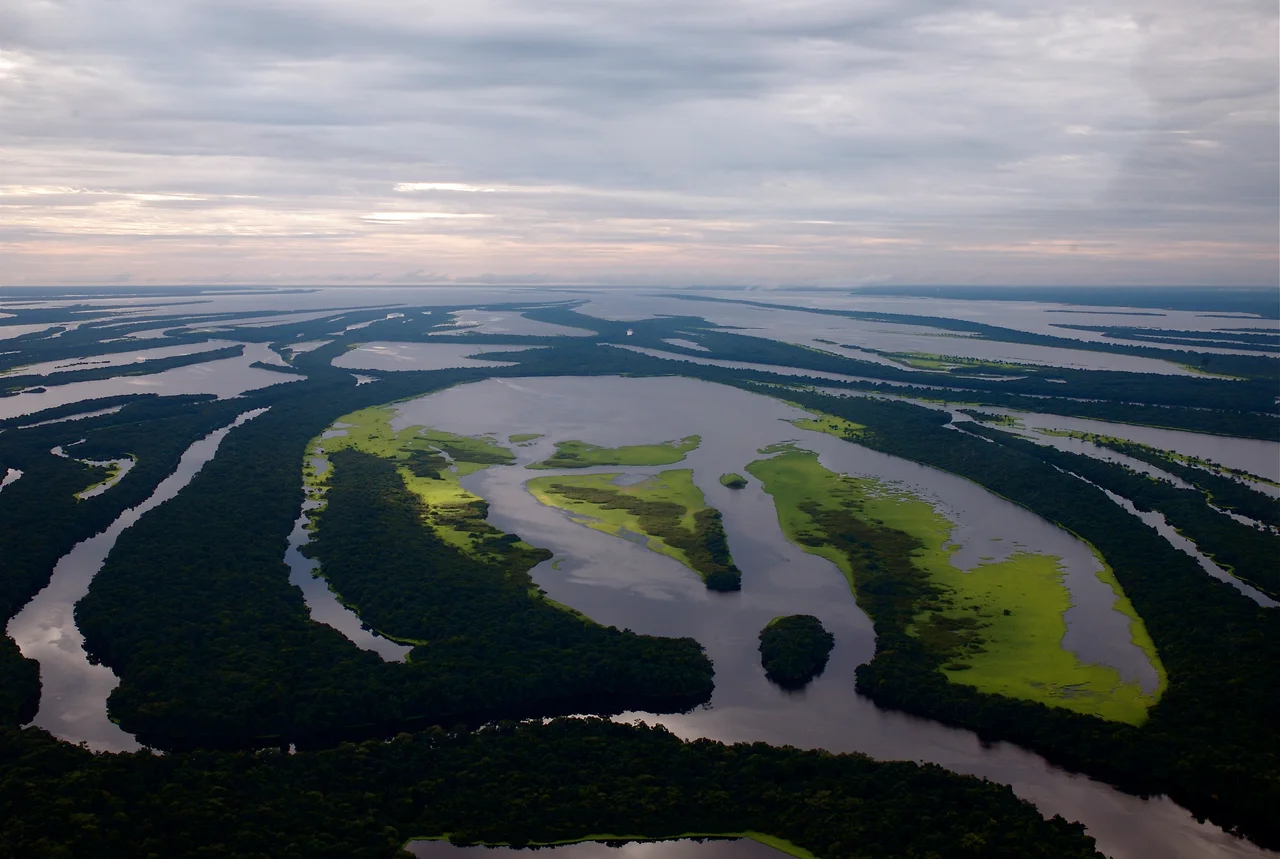
From the Air
Coordinates 3.33 S, 67.92 W at reference center; corridor spans vast territory across Amazonas state. Includes the Solimoes and Rio Negro river basins and the cities of Manaus, Manacapuru, and Tefe. Best aerial viewing during dry season (June-November); frequent rainforest cloud cover otherwise. Major airports: Eduardo Gomes International (SBEG) in Manaus, and regional airports at Tabatinga (SBTT) and Tefe (SBTF).
Nearby Stories
- Ticuna language 3.2 km away
- Tonantins 28 km away
- Leticia 167 km away
- Purus Varzea 175 km away
- Juruá-Purus Moist Forests 197 km away
- Leticia, Amazonas 226 km away
- Mamirauá Sustainable Development Reserve 230 km away
- Solimoes-Japura Moist Forests 271 km away