Purus Varzea
For eight months of the year, the forest floor is underwater. The Purus varzea is a stretch of central Amazonian flood forest where rivers swollen with Andean silt rise by up to twelve meters every wet season, drowning the lower levels of the trees and turning the landscape into a labyrinth of flooded trunks. Fish move through the canopy to eat fruit. Jaguars climb to dry ground. When the water falls away in August, a different version of the same forest emerges, sediment-rich and temporary, and the cycle begins again.
A Forest on a Schedule
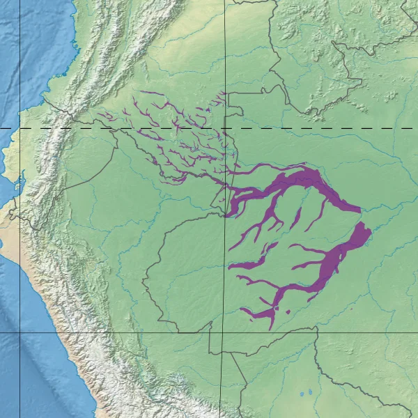
The Purus varzea stretches across 17.7 million hectares of eastern Colombia and western Brazil, following the Jurua, the central Purus, and the Caqueta-Japura rivers and reaching east to where the Japura meets the Solimoes. The towns of Tefe, Tabatinga, and Carauari sit inside or near its edges. Unlike the dark, nutrient-poor blackwater rivers elsewhere in the Amazon, the streams that feed the varzea are whitewater rivers: sediment-heavy flows washed down from the eastern slopes of the Andes. That sediment builds new soil every year. The floodplain is one of the most fertile places on the continent, and also one of the most difficult to inhabit, because the river keeps changing where the dry land is.
Twelve Meters of Water
The flood rises slowly. Water levels climb through the first months of the year, peaking in May or June, and by then the lower trunks of most trees are submerged and the forest floor may lie twelve meters beneath the surface. Rain falls throughout the year, heaviest from January through March and lightest in July and August, and the average annual precipitation is about 2,550 millimeters. Temperatures hold steady at around 26.5 degrees Celsius. The river shifts course constantly in the flat terrain, carving oxbow lakes where meanders get pinched off, building natural levees, leaving bars and swales. The result is a mosaic of habitats that no single species entirely dominates.
The Largest Trees
Ceiba pentandra, the kapok tree, grows largest in the varzea. Its smooth, buttressed trunks rise clear of the seasonal flood and its crown spreads across the upper levees. On lower ground where water sits longer, smaller pioneers take over: Cecropia, Pseudobombax munguba, dozens of species of Ficus, and the spine-trunked Astrocaryum jauari palm. The understory is thick with gingers, heliconias, and the family Marantaceae. The forest here holds more species than the flood forests downstream but fewer than the surrounding terra firme forest that never goes under. One small palm, Bactris tefensis, exists nowhere else. It is named for Tefe, the town sitting on the eastern edge of the ecoregion.
When Fish Eat Fruit
The most striking biological fact about this forest is that during the flood season, fruit-eating fish move into it. Tambaqui, pacu, pirarucu, and sardinha swim among the submerged trees and wait for fruit to drop. Yellow mombin, jauari palm nuts, biriba, taruma, and figs all fall into the water and become food for fish that evolved to catch them. The fish, in turn, disperse seeds across the floodplain when they move. Above the water line, the region holds 199 mammal species, 633 bird species, green anacondas, black caiman, Amazon river dolphins, and tucuxi. Two primates, the bald uakari and the black squirrel monkey, live only in the Mamiraua Sustainable Development Reserve at the ecoregion's edge.
Mammals That Climb or Leave
No ground-dwelling mammals live in the varzea sections cut off from the mainland during the flood. They cannot stay, and they have no dry land to retreat to. In areas where the floodplain touches terra firme forest, animals like the white-lipped peccary, the agouti, the paca, the capybara, and the jaguar migrate uphill for the wet season and come back when the water recedes. The strategies differ by body plan. Primates move through the canopy year-round and barely notice the flood. Caimans and river dolphins treat the flooded forest as extended hunting ground. The animals that cannot swim well and cannot climb well simply leave.
What Threatens It
The World Wildlife Fund classifies the Purus varzea as critical or endangered. Logging and large-scale cattle farming have cleared sections of the forest. Industrial fishing pressure has thinned populations of tambaqui and pirarucu. Ornamental fish collectors hunt blue discus for aquariums in North America and Europe. Perhaps most damaging, gold mining upstream on the Purus and Japura dumps mercury into the river system, where it accumulates in the fish that ribeirinho families along the rivers depend on for food. Conservation units exist, notably the Mamiraua and Amana Sustainable Development Reserves and Jau National Park, but they cover only a fraction of an ecoregion the size of several European countries combined.
From the Air
Centered roughly at 2.39 degrees S, 66.04 degrees W in the central Amazon basin. The ecoregion follows the courses of the Jurua, central Purus, and Caqueta-Japura rivers across eastern Colombia and western Brazil. Nearest airfields are Tefe Airport (SBTF) at the eastern edge and Tabatinga International (SBTT) to the west. Best viewed from 10,000 to 20,000 feet, especially in June and July when the flood is at maximum and the forest canopy reflects off standing water in bright silver patches between darker stretches of unflooded trees.
Nearby Stories
- Japurá-Solimões-Negro Moist Forests 80 km away
- Japurá River 90 km away
- Amanã Sustainable Development Reserve 105 km away
- Amazon biome 151 km away
- Tonantins 153 km away
- Sao Gabriel da Cachoeira 231 km away
- Tariana people 473 km away