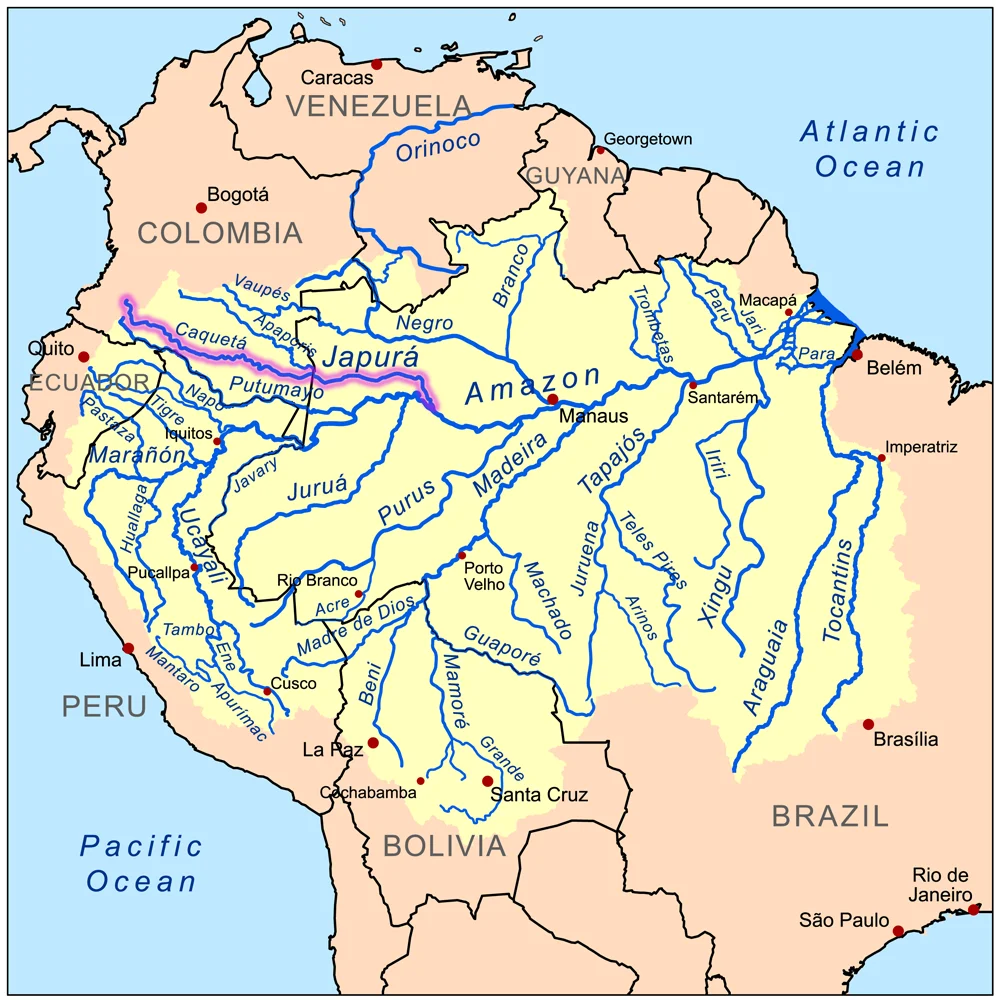
Japurá River
The river has two names because it crosses a border, and the border matters. In Colombia it is the Caquetá, rising in the Andean foothills near the headwaters of the Magdalena and gathering tributaries as it moves southeast. When it crosses into Brazil, the same water becomes the Japurá. Together these are 2,820 kilometers of moving water that eventually slip into the Amazon through a network of channels so braided that a colonial administrator named Francisco Xavier Ribeiro Sampaio spent his 1774 voyage trying to determine which of the eight presumed mouths was real. His answer: only one. The rest are furos and canos, the diverting side-channels by which Amazonian rivers give and take territory with the land they cross.
From the Andes to the Várzea
The Caquetá gathers mass in southwest Colombia, where the eastern Andes break into foothills that have fed rainwater to the Amazon for millions of years. The river runs southeast through a Colombian landscape that Jules Crevaux, descending it in the 19th century, described as full of obstacles - rapids, cataracts, a current that does not forgive inattention. The Baron of Marajó, the Brazilian geographer José Coelho da Gama e Abreu, gave it 970 kilometers of navigable length. For much of that length the water flows through the Purus várzea ecoregion, where seasonal floods rise and fall by many meters, swamping the forest floor each wet season and exposing it again in the dry. The river is home to catfish that grow to 91 kilograms and 1.8 meters, electric eels, piranhas, turtles, and caimans - a complete Amazonian fauna moving through channels the color of strong tea.
Rubber and Ruin
Between the Caquetá and the Putumayo, the Peruvian rubber baron Julio Cesar Arana built an empire on wild rubber and forced labor. The Peruvian Amazon Company, founded by Arana and eventually listed on the London stock exchange, operated stations along the rivers where indigenous people were compelled to extract latex under the threat of torture and death. The Andoque people were concentrated around Matanzas, the station run by Armando Normand - a name the Irish diplomat Roger Casement would later hold up as synonymous with cruelty. The Boras were made to work the stations of Abisinia, Santa Catalina, and La Sabana. Casement and the English traveler Joseph Woodroffe both noted that the Boras and Andoques resisted most vigorously - and suffered proportionally. By 1910, Woodroffe believed, both peoples had been pushed near extinction. Hundreds died at the company stations. The rivers that had carried their canoes for centuries were used, for a time, to carry rubber downriver and ship them into forced labor.
Water Roads
Colonial and imperial administrators paid close attention to this river because it offered shortcuts. The Baron of Marajó counted six easy water routes between the Japurá and the Rio Negro across the low, flat country between them - one connecting the upper Japurá to the Vaupés, a branch of the Negro. That mattered. Such portages meant the indigenous nations on either side could reach each other without descending to the main Amazon. It meant Jesuit missions and later slavers could move between watersheds. In 1864 through 1868 the Brazilian government mapped the river as far upstream as the rapid of Cupati, trying to understand what it had. The answer was a waterway that had been a highway for trade, language, and people long before any surveyor arrived to plot it.
What Moves on It Now
The river still does what rivers in the Amazon do. Dugout canoes carry families between hamlets. Larger motorboats and the riverboats called lanchas carry cargo - sometimes chartered, sometimes doubling as traveling general stores. The waterways knit together villages that no road reaches. For decades the Colombian stretch was constrained by guerrilla presence and military checkpoints, and parts of it still are. The forests along the eastern Caquetá have been cleared for rice, corn, manioc, sugarcane, and - in the last two decades - coca. But the river itself is the constant. Baron Marajó's one true mouth still opens into the Amazon at the point where the Japurá finally stops being itself and becomes part of something larger.
A Base Called Jaburo
In an oddly specific footnote to the river's reach, the Japurá gave its name to the main Earth Federation base in the Mobile Suit Gundam television series - transliterated into Japanese as Jaburo, a subterranean headquarters hidden beneath the Amazon rainforest. The creators wanted an unassailable location for their far-future military command, and a river threading through the deepest rainforest on Earth struck them as the right hiding place. The Japurá, in other words, has become science fiction shorthand for somewhere too dense, too wet, too far in to ever really reach. It is not quite accurate - the river has been mapped and charted and traveled for centuries - but it captures something true about how the Amazon appears from outside. A place a base could disappear into and not be found.
From the Air
Coordinates 3.17 degrees south, 64.78 degrees west, where the Japurá flows through interior Amazonas in Brazil on its way to joining the Solimões. Cruising altitudes of 15,000 to 25,000 feet reveal the braided network of channels and oxbow lakes. Nearest airports are Tefé (SBTF) to the south where the river meets the Solimões, and Tabatinga (SBTT) near the Colombian border. Heavy afternoon convection year-round with the most active storm cells during the December-to-April wet season.
Nearby Stories
- Amazon biome 29 km away
- Amazonas (Brazilian state) 58 km away
- Mamirauá Sustainable Development Reserve 87 km away
- Purus Varzea 120 km away
- Juruá-Purus Moist Forests 186 km away
- Jaú National Park 212 km away
- Amazonas (Brazil) 222 km away