Mamirauá Sustainable Development Reserve
In 1996 the Brazilian state of Amazonas tried something no one had tried before. It created a new category of protected area - the Sustainable Development Reserve - and it drew the first one around 1,124,000 hectares of Amazonian flooded forest between the Solimões and the Japurá. Mamirauá was the test case. The question it asked was blunt: could you protect one of the most biodiverse stretches of flooded rainforest on Earth while also protecting the rights of the 6,306 ribeirinhos, caboclos, Ticuna, Cambeba, and Kokama people who already lived there? The answer required a scientist who had spent his life on the river, an international argument about what conservation was for, and decades of practical work that is still ongoing.
A Triangle Between Two Rivers
The reserve covers an elongated triangle between three stretches of water. To the south, the Solimões - the upper Amazon - runs its whitewater course eastward toward Manaus. To the north, the Auati-Paraná Canal splits off from the Solimões and meanders eastward to rejoin the Japurá River. The Japurá itself runs southward to meet the Solimões at Tefé, closing the triangle. Within those three boundaries sits the reserve, spread across portions of five municipalities: Fonte Boa holds 52 percent of the area, Maraã another 27, Uarini 19, and smaller slivers belong to Japurá and Tonantins. To the north across the Auati-Paraná lies the Auatí-Paraná Extractive Reserve. Across the Japurá to the east lies the Amanã Sustainable Development Reserve. The three protected areas form a connected system that together protect a working piece of Amazonian hydrology.
A New Kind of Reserve
The Sustainable Development Reserve category did not exist before Mamirauá. Traditional Brazilian conservation units came in two broad kinds - fully protected areas like national parks, where human extractive activity was prohibited, and units of sustainable use, which permitted some controlled resource extraction. The problem was that both categories struggled with the reality of Amazonian flooded forest. The ribeirinhos - the river-dwelling traditional communities - had lived in these varzea landscapes for generations, moving their small farms and fisheries with the seasonal flood. Declaring the varzea a strict park would displace them. Declaring it a reserve open to extraction did not give the biodiversity the protection it needed. The SDR model tried to thread the needle: legal recognition of traditional residents' rights combined with strict limits on outside use and an active management partnership between communities and scientists.
The Scientist Who Made It Happen
Mamirauá is the legacy of the Brazilian primatologist José Márcio Ayres, who spent much of his career studying the white uakari, the red-faced bald monkey whose only home is the varzea forests of this stretch of the Amazon. Ayres saw what was happening - hunting pressure from outside the region, illegal fishing, encroachment on uakari habitat - and he saw what the existing conservation toolkit could not do. Working with international partners and Brazilian government agencies, he advocated for a new category of protected area that would put the ribeirinhos at the center rather than outside. The SDR became law through his sustained advocacy. Mamirauá itself was created in 1996 with Ayres as its intellectual architect. He died in 2003, and the reserve continues as an experiment he did not live to see fully mature - though he lived long enough to see it work.
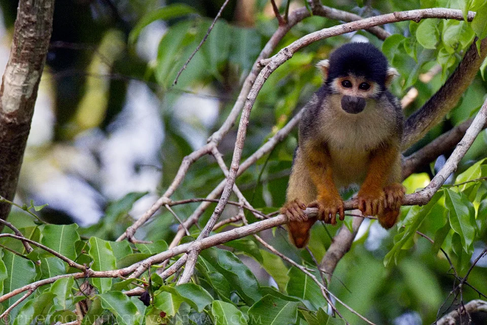
What Lives in the Flood
The reserve sits at the junction of two ecoregions - the Solimões-Japurá moist forests on the upland terra firme edges, and the Purus varzea on the flooded lowlands that make up most of the area. Two primates are endemic. The white uakari, Cacajao calvus calvus, has a face so red and bald it looks like it is perpetually sunburned. The black-headed squirrel monkey, Saimiri vanzolinii, exists nowhere else on Earth. Other primates share the canopy - Juruá red howler monkeys, Peruvian spider monkeys, pygmy marmosets, saki monkeys. Brown-throated sloths hang in the high branches. South American coatis, northern Amazon red squirrels, and collared anteaters move through the understory. Jaguars live here year-round, and during the floods they stay in the trees, becoming arboreal predators in a way few researchers had documented until they started studying Mamirauá specifically. Over 400 bird species have been recorded, including toucans, harpy eagles, hoatzins, and the full range of varzea aquatic birds. In the rivers, tambaqui and piranha and pirarucu swim the channels alongside both kinds of Amazon dolphins - the pink boto and the gray tucuxi.
Recognition, Global and Local
Mamirauá carries some of the heaviest credentials in global conservation. The Ramsar Convention designated it a wetland of international importance, recognizing its role in a global network of protected marshes and floodplains. UNESCO, in 2003, added it to the Central Amazon Conservation Complex - a World Heritage Site that had been inscribed around Jaú National Park in 2000 and then expanded to include Anavilhanas National Park, Amanã Sustainable Development Reserve, and Mamirauá itself. The PPG-7 Program for the Protection of Brazilian Tropical Forests included it in one of the ecological corridors it aimed to implement. None of those designations prevent the pressures on the reserve. Illegal hunting of caimans for their hides is an ongoing problem. Poaching, unregulated fishing, and logging all reach into the edges. But the core experiment continues. Mamirauá remains the place where Brazil, and the world, first tried to see whether protecting the forest and respecting the people inside it could be the same thing.
From the Air
Centered at 2.26 degrees south, 65.68 degrees west, in the triangle between the Solimões and Japurá rivers near Tefé. Cruising altitudes of 10,000 to 20,000 feet show the vast flooded forest of the varzea, the meandering Auati-Paraná Canal, and the confluence of major Amazonian rivers. Nearest airport is Tefé (SBTF) at the reserve's southern edge where the Solimões runs. Expect heavy afternoon convection year-round with peak storm activity in the March-to-September wet cycle.
Nearby Stories
- Japurá-Solimões-Negro Moist Forests 36 km away
- Amanã Sustainable Development Reserve 70 km away
- Amazon biome 75 km away
- Japurá River 117 km away
- Tonantins 195 km away
- Sao Gabriel da Cachoeira 229 km away
- Xixuau 463 km away