Japurá-Solimões-Negro Moist Forests
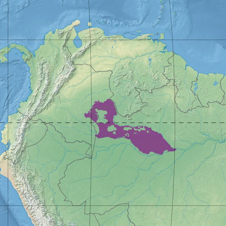
Three rivers define the ecoregion, and two of them are different colors. The Japurá and the Solimões run a pale, silt-heavy brown - whitewater rivers carrying Andean sediment downstream toward the Atlantic. The Rio Negro runs almost black, stained by tannins leached from decaying vegetation in the poor soils of its watershed. Where the black water meets the white at Manaus, the two refuse to mix for kilometers, flowing side by side in visible contrast until turbulence finally blends them. The forest that grew up between these rivers, across 269,617 square kilometers of lowland plateau, learned to live with both - the fertile flood pulse of the whitewater várzea and the nutrient-starved blackwater igapó - and the result is one of the most biodiverse places on Earth.
Between Three Rivers
The ecoregion sits in the central north of Brazilian Amazonia, with a small sliver crossing into Colombia. Its shape is essentially an interfluve - the ground between major rivers - bounded by the Rio Negro on the north and east from the Venezuelan border down to Manaus, and by the Japurá on the south from Colombia to where it meets the Solimões at Tefé. The terrain is mostly terra firme plateau, emerging about 2.5 million years ago as soft sediments settled on the old South American craton. Elevations rarely rise above 80 meters, and at Manaus the land falls to just 23. That flatness matters. It is what lets the annual flood pulse push water far into the forest, and it is what lets the difference in water chemistry - fertile versus poor, alkaline versus acidic - create different forest communities within kilometers of each other.
The Flood Pulse
Every year the rain falls hard - 2,500 millimeters on average - and the rivers rise. Near Tefé and Manaus, the water can climb 14 meters before it starts to drop again. Flooding on smaller rivers lasts a month or two. Near Manaus, where the main-stem Amazon backs up the tributaries, it can persist for ten. Fish swim into the drowned forest and feed on fallen fruit. Tree species that would die elsewhere have evolved to survive submersion of their roots and trunks for most of the year. The Jaú River igapó to the west supports a specific community - Elvasia, Swartzia, Pouteria, Aldina, the slow-growing understory of a forest that floods regularly but is never fertile. Along the Tarumã Mirim to the east, different genera take over - Vismia, Unonopsis, Pentaclethra, Macrolobium. Two forests of the same biome, sorted by which water reached them.
Terra Firme and Campinarana
Most of the ecoregion is not flooded. The terra firme forest - the ground that stays above water year round - makes up the bulk of the landscape and sits on poor, leached soils that have been weathering for millions of years. Canopies reach 25 meters, with emergent Brazil nuts, sucupira, and rubber trees breaking through at 40. Miriti palms cluster in the understory. Within the ecoregion sits a stranger habitat still, the campinarana - patches of white sand soil so nutrient-poor that even the Amazon cannot grow tall forest there. Broad-leaf meadows, dwarf shrubs, and specialized shrublands replace the high canopy. Periodic shallow flooding washes through, and the plants that survive have deep evolutionary investment in conservation - waxy leaves, slow growth, tight cycling of whatever nutrients the rain delivers.
Counted Lives
The numbers do some of the work. 181 mammal species have been recorded here - South American tapir, capybara, jaguar, collared peccary, red-faced spider monkey, red-handed tamarin, squirrel monkeys, several gracile capuchins. Over 100 bat species alone. 506 bird species: macaws in the Ara genus, cattle egrets, herons of Egretta and Ardea, tinamous, parrots. Reptile counts are harder to pin down but include green iguanas, tegu lizards, boa constrictors, the venomous fer-de-lance and bushmaster, coral snakes, and palm pit vipers. The rivers carry Amazon river dolphins and the Amazonian manatee, an herbivore that vanished from so much of its old range it now depends on reserves like Mamirauá and the Jaú. The global ecoregion, called the Rio Negro-Juruá Moist Forests - which includes this ecoregion plus three neighbors - is considered reasonably intact and under-studied by scientists.
Protection and Pressure
Large pieces of the ecoregion sit inside formal protection. The Mamirauá Sustainable Development Reserve, established in 1996 as the world's first of its kind, covers the várzea near Tefé. The Amanã Sustainable Development Reserve extends it north. Jaú National Park, a UNESCO World Heritage Site, protects the entire Jaú River basin. Across the border, the Puinawai Natural Reserve covers the Colombian portion. Outside those boundaries the pressures are real. Gold miners cut into the riverbanks along the Colombia-Brazil frontier. Unregulated logging claims timber along the main rivers. Deforestation and pollution spread outward from Manaus. But there are almost no roads, and rivers carry most of what moves. That inaccessibility, more than any law, has kept the forest here alive - a reminder that some places remain wild because reaching them remains hard.
From the Air
Centered around 1.76 degrees south, 64.76 degrees west in the interfluve between the Japurá and Rio Negro rivers. Cruising altitudes of 15,000 to 25,000 feet reveal the meeting of whitewater and blackwater and the vast carpet of canopy between them. Nearest airports are Tefé (SBTF) where the Japurá meets the Solimões, and Manaus (SBEG) at the confluence with the Rio Negro. Expect heavy afternoon convection year-round with peak storm activity in the March-to-September wet cycle.
Nearby Stories
- Mamirauá Sustainable Development Reserve 36 km away
- Amanã Sustainable Development Reserve 57 km away
- Purus Varzea 94 km away
- Jaú National Park 191 km away
- Sao Gabriel da Cachoeira 248 km away
- Xixuau 321 km away
- Waimiri Atroari Indigenous Territory 489 km away