.JPG)
Amazon biome
The Amazon River carries roughly 16 percent of all the freshwater that rivers deliver to the oceans. No other river on Earth comes close. And yet the Amazon is not really a single thing. The biome it drains covers 6.7 million square kilometers across nine countries - Brazil, Bolivia, Peru, Ecuador, Colombia, Venezuela, Guyana, Suriname, and French Guiana. Nearly half of it sits inside Brazil. Within that expanse the forest changes constantly: terra firma high forest that never floods, várzea floodplains soaked in whitewater silt, igapó flooded forests drowned in blackwater, bamboo groves that flower together every 27 years then die, and at the highest edges, alpine tundra on the flat-topped tepuis of the Venezuelan border.
How Many Species Does a Place Hold
The rough answer for the Amazon biome is: more than anyone has finished counting. Estimates of plant species range from 30,000 to 60,000, with perhaps half of them endemic to the biome - existing nowhere else. There are 1,400 known species of fish in the Amazon basin, 163 amphibians, 387 reptiles, and more than 500 mammals including roughly 90 species of primates. Of the amphibians, 87 percent live only here. Of the reptiles, 62 percent. Of the mammals, 25 percent. The 1,300 bird species include 20 percent endemics and 8.4 percent currently endangered. The Iquitos Arch - one of several ancient geological ridges that cross the basin - separates western frog and rodent species from their eastern cousins, because the arches acted as barriers to dispersal over millions of years. The Amazon is not one forest. It is dozens of sub-basins, each with its own evolutionary history.
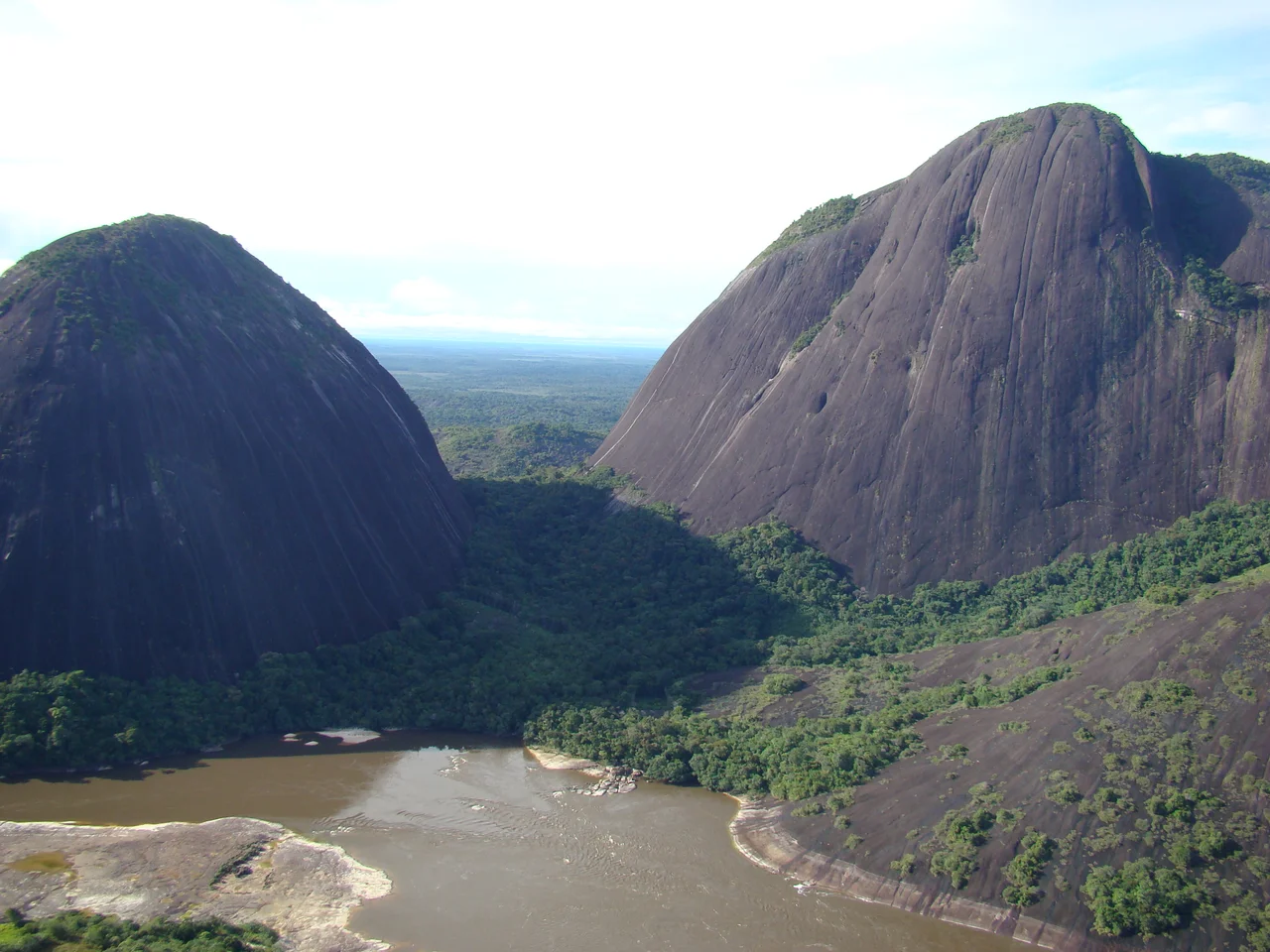
Black Water and White Water
At the Meeting of the Waters outside Manaus, the Rio Negro and the Solimões flow side by side for about six kilometers without mixing. The Rio Negro is nearly jet black - its color comes from tannins released by decomposing leaves in swamps along its margins. It runs clear. The Solimões runs yellow-brown, heavy with silt scoured out of the Andes. The two rivers have different temperatures, different chemistry, different speeds. Only when they merge and slow into the lower Amazon do they finally combine. Hydrographers divide Amazon rivers into three basic types: blackwater like the Negro, whitewater like the Solimões and the Amazon itself, and clearwater like the Tapajós. Each feeds a different kind of flooded forest. The blackwater feeds igapó. The whitewater feeds várzea. The distinction governs everything from the fish that live there to the trees that line the banks.
Soil the Trees Made
For a rainforest with such staggering biological wealth, the Amazon's soils are surprisingly poor. Most of the basin is ferralsols and acrisols - old, heavily weathered, acidic, and low in nutrients. About 20 percent of the Rio Negro basin is covered by true podzols, sandy soils that hold almost nothing. When colonial-era farmers tried to convert rainforest to permanent agriculture, the soils failed them within a few years. The system works only because the forest itself is the nutrient reservoir. Leaves fall, fungi decompose them, and roots reclaim the nutrients before rain can wash them away. Remarkably, a large fraction of the phosphorus that makes the whole system run blows in from Africa - diatomaceous dust from the Bodélé Depression in Chad, carried across the Atlantic by trade winds, dropped onto the canopy by tropical rainfall. The Amazon is fertilized by the Sahara.
The Ecosystems, Mapped
The biologist J.J. Morrone divided the biome into biogeographical provinces: Guyana, Humid Guyana, Napo, Imeri, Roraima, Amapá, Várzea, Ucayali, Madeira, Tapajós-Xingu, Pará, Yungas, and Pantanal. The World Wildlife Fund's map counts 53 major ecosystems and more than 600 types of habitat. Among the moist forests are the Juruá-Purus, the Madeira-Tapajós, the Tapajós-Xingu, the Napo, the Southwest Amazon, the Xingu-Tocantins-Araguaia. Each zone carries its own plant and animal communities. The tepuis at the northern edge - the sandstone tabletop mountains of the Guiana Shield - hold carnivorous plants that evolved to digest insects because the tops of the tepuis are too leached of nutrients to grow plants any other way. Pico da Neblina at the Venezuela border rises 2,995 meters above sea level; it is the highest peak in Brazil, and the last hundred meters of its summit carry alpine tundra in a biome otherwise defined by rainforest.
What Is Being Eaten Away
About 16 percent of the Brazilian Amazon had been deforested by 2006. Between 2006 and 2011 another 45,100 square kilometers fell - most of it in Mato Grosso, Pará, and Rondônia, the three states along what is called the Arc of Deforestation. Cattle pasture accounts for most of the loss. In a 2009 survey of 620 recently cleared plots, 32 percent had become pasture and less than one percent had become soybean fields. Soy farmers mostly work the cerrado savanna to the south. Satellite imagery along the BR-364 highway in Acre shows deforestation in herringbone patterns - access roads striking off the highway in parallel lines, each new road opening another strip of forest to clearing. In 2000, Brazil banned sugarcane plantations in the biome. In 2010, low-interest credit was offered for oil palm, but only on land already cleared before 2008. The Amazon biome now holds 247 federal and state protected areas covering 1.1 million square kilometers - 73 percent of all the area Brazil protects at those two government levels. The rest of the biome remains the world's single largest natural question: what survives and what does not.
From the Air
The nominal coordinates (2.97 degrees south, 64.60 degrees west) place this near the center of Amazonas state, Brazil, close to the Japurá and Solimões rivers. The biome itself covers 6.7 million square kilometers and spans nine South American countries. From cruising altitude over central Amazonia, the unbroken green canopy stretches to the horizon; the major rivers appear as wide, sinuous brown or black lines depending on whether they are whitewater or blackwater. The Meeting of the Waters at Manaus is visible from the air as a distinct line between dark and light water. Nearest major airport is Eduardo Gomes International (SBEG) in Manaus. During the August-October dry season, fire smoke can reduce visibility across the southern arc of the biome.
Nearby Stories
- Amanã Sustainable Development Reserve 27 km away
- Japurá River 30 km away
- Mamirauá Sustainable Development Reserve 83 km away
- Purus Varzea 125 km away
- Jaú National Park 161 km away
- 2019 Amazon rainforest wildfires 197 km away
- Juruá-Purus Moist Forests 241 km away