Solimoes-Japura Moist Forests
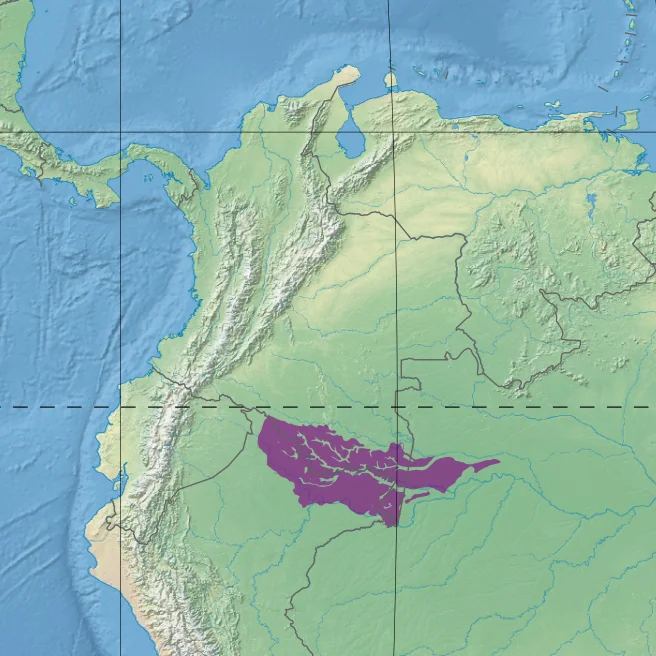
Two short roads. That is all the infrastructure that crosses the Solimoes-Japura moist forests, an ecoregion of 16,757,223 hectares spread across the borders of Brazil, Peru, and Colombia. For scale: if you placed the ecoregion over Europe, it would blanket Greece and spill into Italy. For context: 500 species of birds have been recorded in just one Colombian park inside its boundaries. The rivers do the work that roads do elsewhere. The Caqueta runs down from the Andes, crosses into Brazil and becomes the Japura. The Napo arrives from Ecuador. The Putumayo marks the border between Colombia and Peru. They all eventually meet the Amazon, which this far upstream is called the Solimoes. The forest they drain is one of the last large intact stretches on Earth.
Rivers Define Everything
In the Amazon, rivers are not borders so much as organizing principles. The Solimoes-Japura ecoregion is hemmed in by water on almost every side. The Caqueta-Japura system forms the northern boundary, separating it from the Caqueta moist forests above. The Solimoes itself defines much of the southern edge, with the flooded varzea forests of Purus and Iquitos lying between this terra firme ecoregion and the southern Amazon basin. The Napo River separates it from the Napo moist forests to the west. These rivers carry whitewater, heavy with organic and mineral sediments scoured from the Andes, which they deposit during annual floods to enrich the floodplains with nutrients the upland forests never receive. Soils off the floodplain are oxisols and ultisols, poor in nutrients, high in aluminum and iron, which explains why the richest biomass in the Amazon often sits on the riverbanks rather than in the interior.
181 Mammals
Biologists have cataloged 181 species of mammals in the Solimoes-Japura forests. The predators include jaguar and margay, ghost cats moving through the understory at dawn and dusk. The tapir, South America's largest native land mammal, wades through swamp forest browsing on fruit. Anteaters of three sizes work the lowland trails: giant, southern tamandua, and the house-cat-sized silky anteater clinging to branches. Monkey diversity runs especially high. The equatorial saki, the golden-mantled tamarin, and Goeldi's marmoset are all here. Endangered species include the white-bellied spider monkey and the giant otter, a two-meter predator that was once nearly extirpated by fur trappers. In the flooded areas, West Indian manatees still graze on underwater grasses. The bat list alone runs to more than fifty species, including obscure specialists like the southern little yellow-eared bat and Schmidts's big-eared bat.
Birds and Reptiles
About 542 bird species have been recorded, 500 of them in Colombia's Amacayacu National Park alone. A few are rare or nearly endemic to the region: the pavonine quetzal, a trogon with an iridescent green tail; the white-eared jacamar, which hawks insects from forest-edge perches; the wattled curassow, a large terrestrial bird now endangered by hunting. The reptile fauna includes Arrau turtles, spectacled caiman, green iguanas, and tegu lizards. Snakes account for some of the Amazon's most formidable: green anacondas, fer-de-lance, palm pit-vipers, coral snakes, emerald tree boas, and bushmasters, the longest pit viper in the world. The waters hold silver arowana leaping for insects, piranha shoals, and ocellate river stingrays half-buried in the silt. Amphibians are still being catalogued. Johnson's horned treefrog, a species described only recently, is already listed as endangered.
Canopy Over Canopy
The forest itself is structurally complex in a way photographs rarely convey. The dense upland canopy reaches 35 meters, with emergent trees rising to 40. Below the canopy, a tangle of lianas, palms, epiphytes, mosses, and ferns fills every vertical layer that light can reach. The most common tree families are Annonaceae, Lecythidaceae, Myristicaceae, Fabaceae, and Sapotaceae. Emergents include the kapok (Ceiba pentandra), whose buttressed trunks can be four meters across, and Cedrelinga cateniformis, sometimes called Amazonian cedar. The Peruvian part of the ecoregion contains patches of nutrient-poor white sand that host a distinctive sclerophyll scrub with high endemism. In Colombia, sandstone plateaus rise to 500 meters, dressed in shrub and savanna vegetation related to the flora of the Guiana Highlands to the east. Fifteen different vegetation types have been described in just one Colombian portion of the ecoregion.
Under Pressure
The World Wildlife Fund classifies the Solimoes-Japura forests as Relatively Stable and Intact, but the qualifier matters. Along the Caqueta and Putumayo rivers in Colombia, deforestation has advanced for coca cultivation, illegal logging, mining, and cattle ranching. Colombia has strong forest laws that are poorly enforced. Most of the mahogany is gone, cut out of the forest decades ago. Most of the tropical cedar has been logged along the main rivers. About one third of the ecoregion, the strip between the Putumayo and the Caqueta in Colombia, is indigenous territory, where communities practice small-scale shifting agriculture and extraction of non-timber forest products. Protected areas include Colombia's Cahuinari and Amacayacu national parks, together covering 8,690 square kilometers, and Brazil's Mamiraua Sustainable Development Reserve, a pioneering model that combines conservation with the livelihoods of riverine caboclo communities who have lived in the forest for generations.
From the Air
Centered at approximately 2.41 S, 70.92 W in the western Amazon basin. The ecoregion spans 16.7 million hectares across Brazil, Peru, and Colombia, bounded by the Caqueta-Japura River to the north, the Solimoes to the south, and the Napo to the west. Elevations range from 100 to 500 m. Recommended viewing altitude 7,000 to 9,000 m for the best sense of the unbroken canopy. Nearest major airport is Leticia's Vasquez Cobo International (SKLT) at the Colombia-Brazil border. Short flights connect regional hubs, but most travel within the ecoregion is by boat along the major rivers. The view from altitude is of a green ocean threaded with brown river channels.
Nearby Stories
- Puerto Nariño 138 km away
- Leticia, Amazonas 180 km away
- Tabatinga 213 km away
- Great Depression in Latin America 237 km away
- Iquitos 242 km away
- Tariana people 353 km away
- Nuevo Rocafuerte 467 km away