
Iraft
Water arrives at Iraft the way water arrives at any delta - fanning out, slowing down, letting go of whatever it was carrying. What is unusual here is the scale of the thing it arrives at. Iraft covers 3.06 square kilometres and averages 7.3 metres deep, holding about 19.5 million cubic metres: less a lake than a wide, patient stretch of the Laisälven river, sitting 455.6 metres above a sea that is still 444 kilometres away. Red cabins cluster at Bäverholmen on the southwestern side, where the braided channels of the Yraft delta come in. Along the northern shore runs Kungsleden, the King's Trail. This is a small lake by the standards of Swedish Lapland, and it is worth knowing about for an unfashionable reason: almost nothing has ever been done to it.
A Wide Place in a River
Sweden measures its water with unromantic care, and the figures for Iraft are modest and exact. Maximum depth twenty-eight metres, in a single trough. Mean depth 7.3. Surface elevation 455.6 metres. The lake sits at the bottom of a drainage basin that the Swedish Meteorological and Hydrological Institute calls the Iraft outlet - 46.63 square kilometres of ground whose average altitude, 594 metres, is well above the lake itself. Everything here runs downhill and arrives. Two-thirds of that ground is forest. Roughly a sixth is bare rock, the scoured grey shoulders that give these valleys their unfinished look, as though the ice had left last week rather than nine thousand years ago. Only 8.2 percent of the basin is open water, a low figure for Lapland, and it tells you what kind of terrain this is: steep country that sheds its rain rather than pooling it.
The Long Way to the Sea
Follow a drop of water out of Iraft and it takes a curiously indirect route home. The Laisälven carries it southeast into the Vindelälven, and the Vindelälven into the Ume River, which finally reaches the Gulf of Bothnia. Hydrologists give the Laisälven tributary order three: three separate watercourses, and 444 kilometres of travelling, before the water is done. Count in the 48 catchments upstream and the total contributing area comes to 1,195.77 square kilometres of mountain, birch forest and bog - a piece of country a little larger than Hong Kong, funnelling itself through a lake a fit person could row across before lunch. Stand at the delta on a still morning and you are watching the drainage of an entire mountain district go by at walking pace.
Along the Northern Shore
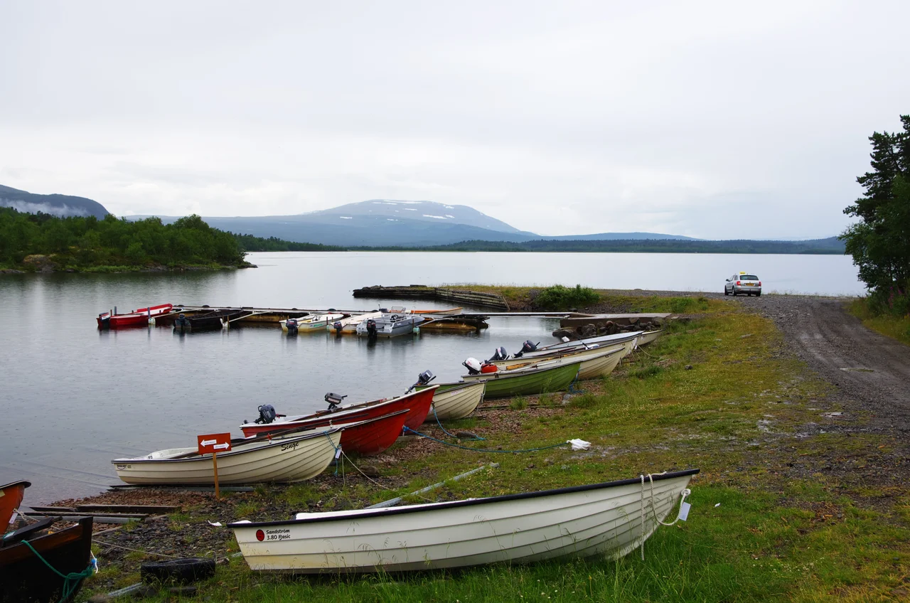
Kungsleden hugs Iraft's northern shore, rounding the inlet at Ahaviken in the northwest before dropping past Bäverholmen. Where Sweden's long-distance trails meet water, the solution is disarmingly analogue: rowing boats, left on the bank, maintained by the county administrative board of Norrbotten and the Swedish Tourist Association, generally usable once the ice has gone in late June or early July. Local charter boats run as well, for walkers who would rather not spend an hour at the oars with a pack in the bow. There is no bridge here and no ferry timetable. You look at the water, you look at the boats, and you work it out - a system that has survived on this trail since the Swedish Tourist Association first began marking out a route through the mountains in the late nineteenth century.
Water That Was Left Alone
Iraft lies inside the Laisälven Natura 2000 area, part of the European Union's network of protected habitats, and the Swedish water authority's assessment of the lake reads mostly as a list of absences. Good ecological status. Good chemical status. No recorded problem with acidification, nutrient loading, pollutants, invasive species or morphological change. That last item carries the weight. Barely twenty kilometres north, over the watershed, the lake Sädvvájávrre rises and falls through more than sixteen metres of range each year as a storage reservoir for the heavily developed Skellefte River. Iraft does none of that. It freezes and thaws, the delta quietly rearranges its channels, and the surface stays where the retreating ice put it. In a country that dammed most of its northern rivers inside a single generation, an ordinary lake behaving ordinarily has become the unusual case.
From the Air
Iraft lies at 66.285N, 16.609E in western Arjeplog Municipality, Swedish Lapland, roughly 45 km east of the Norwegian border and well north of the Arctic Circle. The lake is small - about 3 km long - but the Yraft delta at its southwestern end is a distinctive braided fan that reads clearly from the air, and the Laisälven valley itself forms an unmistakable northwest-southeast corridor through otherwise trackless fell country. Best appreciated from 2,000-4,000 feet AGL, where the delta channels and the pale bare-rock ridges above the treeline both show well. Nearest airports are Arvidsjaur (ESNX) roughly 150 km southeast and Gällivare (ESNG) to the northeast; Bodø (ENBO) in Norway lies about 150 km northwest across the border. Summer brings long light and frequent low cloud on the fell tops. Winter visibility can be superb, but the lake is snow-covered and hard to pick out from the surrounding bog.
Nearby Stories
- Lapland (Sweden) 18 km away
- Skellefte River 22 km away
- Vindelfjällen Nature Reserve 25 km away
- Nasa Silver Mine 37 km away
- Kungsleden 43 km away
- Junkerdal National Park 49 km away
- Kallak Mine 96 km away
- Boden Fortress 204 km away