
Island Rail Corridor
The last spike was gold and the hammer was silver. On 13 August 1886, at Cliffside near Shawnigan Lake, Prime Minister John A. Macdonald drove it home on the only visit he ever made to British Columbia, completing three and a half years of construction on the Esquimalt & Nanaimo Railway. The ceremony was out of all proportion to the railway: a line up one side of an island. But the E&N had not been built for its traffic. It had been built to settle an argument that had nearly torn the young Dominion apart, and it had been paid for with something close to a fifth of Vancouver Island.
The Promise That Nearly Broke Confederation
When British Columbia entered Canada in 1871, the terms of union required Ottawa to begin building a railway to the Pacific within two years, linking Victoria to the rest of the country. The province, for its part, would hand over a band of public land along the route. Ottawa was in no hurry. An island railway had thin traffic potential and would duplicate a perfectly good steamer service, and both the federal government and the Canadian Pacific put it near the bottom of the list. By 1874 British Columbia was openly threatening to withdraw from Confederation. The dispute went to arbitration before the Earl of Carnarvon, whose award that November extended the deadline but required a railway from Esquimalt to Nanaimo. Both sides had promised to be bound by it. Then the bill approving it died in the Canadian Senate, and the threats of secession started again. Speaking in the Commons in 1881, Macdonald called the original bargain a sacred obligation - a treaty with British Columbia, sanctioned by the imperial government itself.
Dunsmuir's Bargain
The man who eventually built it was Robert Dunsmuir, the Nanaimo coal baron, who happened also to be a sitting member of the provincial legislature negotiating with itself, which raised eyebrows then and reads worse now. He incorporated the E&N with three California partners - Charles Crocker, Collis P. Huntington and Leland Stanford - and held half the shares. In 1883, after a rival bid collapsed, the province signed with Dunsmuir. The price was extraordinary: roughly 800,000 acres of Vancouver Island, plus a federal cash grant of $750,000. The land came with mineral rights and every known coal deposit on it, and amounted to nearly a tenth of the island; successive grants through to 1925 brought the total to about a fifth. Much of it was old-growth forest, and the proceeds helped build Craigdarroch Castle in Victoria. People were already living on parts of this land, and the courts eventually ruled that the grant did not entitle the railway to dispossess them; the province's Settlement Act of December 1883 acknowledged their surface rights. In 1905 Robert's son James, by then a former premier, sold the whole railway to the Canadian Pacific.
Reaching and Retreating
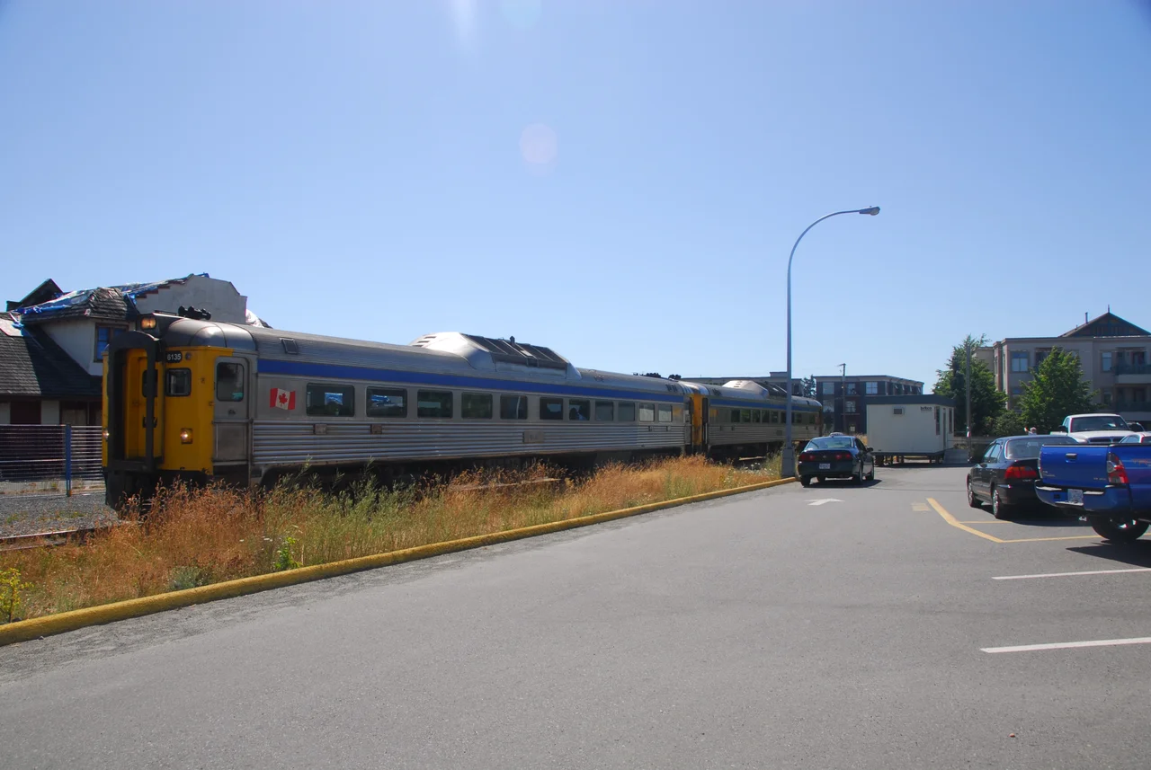
Under the CPR the line kept growing. Rails reached Wellington in 1887, Victoria in 1888, Port Alberni in 1911, Lake Cowichan in 1912, and Courtenay in 1914. The plan had been to carry on north to Campbell River; the First World War ended that. Then the century turned against it. VIA Rail took over the passenger service in 1978, running Budd-built Dayliners with flag stops for anyone who waved. Meanwhile the province rebuilt Highway 1 and pushed a new freeway north from Nanaimo, subsidised in a way the privately-held railway beside it never was. Freight fell from about 8,500 carloads a year in the late 1990s to roughly a thousand by 2008 - against a rough industry benchmark of a hundred cars per mile per year, the E&N was running about 6.6.
Temporarily Suspended
In 2011, with decades of deferred maintenance finally catching up to the track, VIA and the operating railway suspended the Victoria-Courtenay passenger train indefinitely. The word used was temporary, and it has now been temporary for well over a decade. A replacement bus ran for a few months and was discontinued on 7 August 2011, having carried fewer than ten people a day. Freight held on longer but not much: in November 2014, after a safety assessment on track so degraded that trains had been slowing year by year, service over much of the Duncan-to-Parksville stretch stopped too. Agreements to restart passenger service were signed and then shelved while governments studied the repair bill. The Dayliners themselves have left the island; at least one now belongs to a model railway company.
Owned by Everybody
Rather than being abandoned and broken up, the corridor was given away. The Island Corridor Foundation - a registered charity formed as a partnership between Cowichan Tribes and the local governments strung along the line - negotiated for years, and in February 2006 the Canadian Pacific donated its 225-kilometre right-of-way from Victoria to Courtenay, along with six historic stations, a number of trestles and $2.3 million in seed money, in exchange for a tax credit valued at around $236 million. The following month RailAmerica handed over the Nanaimo-to-Port Alberni section. The Foundation now holds 289 kilometres of continuous corridor through the most populated part of Vancouver Island, most of it quiet. More than a hundred kilometres of walking and cycling trail run alongside the tracks, and a coalition formed in 2020 keeps pressing to make the old E&N the spine of the island's transport network again. The rails are still there. That is the whole point of keeping them.
From the Air
The Island Rail Corridor runs 225 km up the east side of Vancouver Island from Victoria to Courtenay, with a 64 km branch from Parksville west to Port Alberni - 289 km of right-of-way in total. The reference point here, 48.4825 N, 123.5574 W, sits on the southern section near Langford, west of Victoria. From the air the corridor is best traced as a thin cleared line paralleling the Island Highway and the eastern shoreline, crossing river valleys on trestles and threading the Malahat ridge north of Victoria; its most photogenic structure is the steel cantilever bridge over Niagara Creek Canyon about 17 km north of Victoria, a span prefabricated in England in 1883 that once crossed the Fraser River at Cisco before being moved here around 1910. Victoria International (CYYJ) is the southern anchor, with Nanaimo (CYCD) mid-island and Comox (CYQQ) near the northern terminus at Courtenay; the Port Alberni branch runs inland toward the head of the Alberni Inlet. A viewing altitude of 3,500 to 5,500 feet MSL follows the route comfortably while clearing the Malahat and the ridges west of Nanaimo. Expect low cloud on the Malahat section in winter and morning marine layer along the Strait of Georgia shoreline in summer.
Nearby Stories
- Arbutus Ridge, Cowichan Valley 2.5 km away
- San Juan Island National Historical Park 4.5 km away
- Eastsound 11 km away
- Juan de Fuca Marine Trail 11 km away
- Mesachie Lake 13 km away
- Sappho, Washington 17 km away
- Spruce Railroad Trail 19 km away
- Port Townsend 22 km away