Itapira
On February 11, 1888, a police chief named Joaquim Firmino de Araujo Cunha was murdered in his own office in a small Sao Paulo coffee town. His crime, in the eyes of the local slave-owning planters, was that he had joined the abolitionist movement and was sheltering enslaved people who had fled to him for protection. The killers were his neighbors. The Brazilian empire was three months away from formally abolishing slavery, and the murder shocked the country. When it was over, the town decided it wanted to forget what had happened. In 1890 the city council petitioned the state to change the name of Penha do Rio do Peixe so that, as the official record put it, the pitiful occurrence might fall into forgetfulness. The new name was Itapira.
A Name Chosen to Forget
Itapira means, according to the nineteenth-century geographical dictionary of Joao Mendes Caldeira, stone tip or pointed stone. It comes from the Tupi ita, stone, plus pira, tip or cliff. A name with no freight, chosen because the old name had too much. The Economist magazine wrote about the murder in 2013 under the headline How an unsolved murder in 1888 played a part in bringing about the end of slavery, arguing that the killing of Joaquim Firmino catalyzed abolitionist sentiment in the final weeks before Princess Isabel signed the Lei Aurea on May 13, 1888. The story of Joaquim Firmino deserves to be remembered. The enslaved people he protected deserve to be remembered. The men who murdered him, and the neighbors who knew them and said nothing, are part of the same history. The town's effort to bury the story through a name change is an object lesson in the limits of administrative forgetfulness. The new name is on the road signs. The old story is on Wikipedia, in The Economist archives, and in the public record.
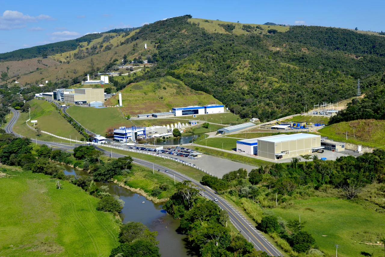
The City of the Mad
Itapira's modern identity was shaped by a different decision made decades later. In 1937, a group of spiritists of the Kardecist tradition founded the Instituto Bairral, a psychiatric hospital that would become one of the largest in area in the Americas. The Santa Fe Rest Clinic and a Cristalia clinic on the road to Lindoia followed. Today Itapira is sometimes called the Cidade dos Loucos, the City of the Mad, because it concentrates a remarkable density of psychiatric treatment facilities in what is otherwise a small interior town of about 75,000 people. Bairral in particular brought innovative concepts to mid-twentieth-century Brazilian psychiatry, including milieu therapy approaches that were progressive for their era. Around the hospitals grew a service economy: psychiatrists, psychologists, social workers, pharmacists. The nickname is worn with a mixture of affection and discomfort, a name chosen by others that the town has come to inhabit.
The Captain Who Raised the Trophy
Sports has its own memorial in Itapira. Hilderaldo Luiz Bellini debuted with Sociedade Esportiva Itapirense in 1946. Twelve years later, he captained the Brazilian national team that won the 1958 World Cup in Sweden, the first of Brazil's five trophies. Bellini is credited as the first World Cup captain to lift the trophy high above his head when he received it from Swedish officials, a gesture that has since become one of football's most recognizable images. Photographers reportedly asked him to raise the trophy higher so they could get a clearer shot. He did. The pose stuck. Bellini went on to play for Vasco and Sao Paulo, captained Brazil at the 1962 World Cup which the team also won though he did not play in the final, and retired with a record that placed him among the best defenders of his generation. He died on March 20, 2014 in Sao Paulo at the age of 83, after Alzheimer's disease had gradually taken his memory. He was buried here in Itapira, where the municipal stadium is called Coronel Francisco Vieira, known locally as Chico Vieira, and where his hometown gave him the full honors he had earned on a field in Stockholm half a century earlier.
From Macuco to Itapira
The town's first name, before Penha do Rio do Peixe and before Nossa Senhora da Penha, was Macuco. Joao Goncalves de Morais and Manuel Pereira da Silva are remembered as its founders, both men who owned tracts of land here in the early nineteenth century. Morais donated land to the Catholic church, and a small wooden chapel was inaugurated on March 19, 1821 with the first mass celebrated by Father Antonio de Araujo Ferraz. In 1840 the rich farmer Joao Baptista de Araujo Cintra arrived from Atibaia, bringing coffee cultivation with him. Emperor Dom Pedro II and Empress Teresa Cristina visited his residence on October 27, 1886, a mark of the social standing the coffee elite had achieved by the end of the imperial period. Seventeen months later, the emperor's policeman was murdered in the same town, by the same class of landholders who had hosted the monarch at dinner. The proximity of those two moments in the town's history tells you more about imperial Brazil than any monument.
What Itapira Grows Now
The coffee that once made the planters rich has declined in importance here, replaced by oranges, sugarcane, cattle, and a manufacturing base that specializes in wood and paper products, agricultural machinery, and ethanol production. The town sits at 643 meters above sea level in a position that puts it within commuting distance of Campinas, 70 kilometers southwest, and many Itapirenses work in that larger city. The town's historical museum displays relics from one of the last major battles of the 1932 Paulista War, fought in this region when the state of Sao Paulo rose in revolt against the central government of Getulio Vargas. Each layer of history is archived somewhere in Itapira. Slavery. Abolition. Monarchy. Republic. Revolt. Industry. Even the names the town has worn and the names it has tried to forget.
From Above
From cruising altitude, Itapira sits in the interior Sao Paulo plateau country, a compact town at 643 meters surrounded by orange groves, sugarcane fields, and the geometric lines of mechanized agriculture. The Bairral Institute occupies a large campus on one edge of the city, a distinctive block visible from above. The Rio do Peixe threads through the agricultural landscape, the same river that gave the town its middle name for a few decades in the nineteenth century.
From the Air
Coordinates: 22.44 degrees south, 46.82 degrees west. Recommended viewing altitude 4,000 to 6,500 feet above the interior plateau (surface elevation 643 meters / 2,110 feet). The nearest major airport is Viracopos at Campinas (VCP / SBKP) about 70 km southwest, with Sao Paulo Guarulhos (GRU / SBGR) 130 km south. The surrounding terrain is rolling interior Sao Paulo agricultural country. Expect afternoon buildups in summer, particularly January and February.
Nearby Stories
- Campinas Cathedral Shooting 29 km away
- Vargem Grande do Sul 35 km away
- Count of Pinhal Mansion 47 km away
- Captaincy of São Paulo 47 km away
- Pouso Alegre 53 km away
- Campos do Jordao 84 km away
- Varginha UFO Incident 119 km away
- Atlantic Forest Biosphere Reserve 175 km away