Pouso Alegre
In 1797, Governor Dom Bernardo Jose de Lorena, the Baron of Sarzedas, rode through a gold-mining village in the valley of the Sapucai River and felt something he had not felt on the rest of his journey. He reined in, looked at the vast and clean horizons, and declared that the settlement was miscalled. It should not be Mandu, he said. It should be Pouso Alegre - a joyful stay. The name stuck. Two centuries on, it describes a city of 152,000 that sits almost exactly halfway between Sao Paulo and Rio de Janeiro, on the interstate highway BR-381, and pulls in factories and logistics operators by the dozen.
Before the Naming
The first Europeans to reach the region were bandeirantes, the legendary Sao Paulo expeditioners who ranged across Brazil looking for gold, precious stones, and indigenous people to enslave. They arrived in 1596, two centuries before the governor's visit. Gold was found at the Santana mines nearby, and a village sprang up with the Tupi-derived name Matosinho do Mandu - the first name of what would become Pouso Alegre. New paths were cut to link the settlement with Sao Paulo and with Vila Rica, the old colonial capital where the gold of Minas Gerais passed through on its way to the Portuguese crown. For almost two hundred years, Mandu was a dusty mining outpost on a forgotten road. Then a governor happened by, and the road became busier than he could have imagined.
The Fernao Dias Corridor
Highway BR-381, known as the Rodovia Fernao Dias, is one of the most important interstate arteries in Brazil. It connects Sao Paulo - the country's commercial capital - with Belo Horizonte, the capital of Minas Gerais. Pouso Alegre sits nearly at its midpoint: 202 kilometers from Sao Paulo, 385 kilometers from Belo Horizonte. That single fact has defined the city's modern economy. Trucks roll through at all hours. Distribution centers have multiplied. Multinationals - Unilever, Ball Corporation, Alpargatas, Yoki - operate plants here, alongside national pharmaceutical companies and automotive suppliers like Johnson Controls and Sumidenso. In 2012, Pouso Alegre received the largest Chinese investment in Latin America when XCMG and YOFC set up heavy-machinery operations. Between 2008 and 2012, eighteen industries settled in the city in the space of four years.
The Highest Building
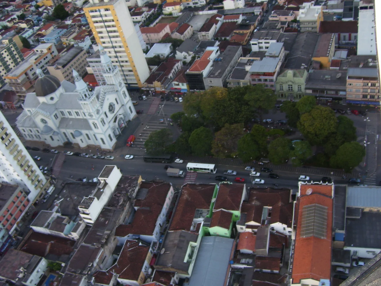
Since 2004 the tallest structure in Pouso Alegre has been the Octavio Meyer building: twenty floors, seventy meters. In a city of mostly low-rise construction, it dominates the skyline like a blunt statement. Pouso Alegre has grown from 94,354 residents in 1996 to 152,549 by 2020, with the population climbing 16.53 percent between the 2010 and 2022 censuses alone. It is the second most populous municipality in southern Minas Gerais and the seventeenth largest in the state overall. The center is densely built, the commercial district holds more than 4,500 stores, and the Manduzao - formally the Estadio Municipal Irmao Gino Maria Rossi, a 17,000-seat stadium nicknamed for the old village name - hosts Pouso Alegre Futebol Clube in local competition.
Neighbors
The city's distance chart reads like a lesson in Brazilian geography. Itajuba is 65 kilometers away. Santa Rita do Sapucai - the Vale do Silicio Mineiro, the Mineiran Silicon Valley - is just 25 kilometers up the road, which means many of the electronics engineers who graduate from INATEL live in Pouso Alegre and commute. The dry port at Varginha, which handles customs clearance for international shipments inland from the coast, is 123 kilometers. Pocos de Caldas, the thermal resort, sits 100 kilometers west. Santos, the port of Sao Paulo, is 260 kilometers by road. Guarulhos international airport is 180 kilometers. The city is close enough to everything important that it functions, in effect, as a shared service hub for half of southern Minas Gerais.
The Valley It Sits In
The Sapucai River gives the valley its shape. Pouso Alegre lies at the confluence of the Rio Mandu and the Sapucai, surrounded by rolling terrain, the Serra da Mantiqueira rising to the east. The climate is what Brazilians call tropical de altitude - mild for the latitude, colder than the coast, with real winters that occasionally bring frost. The founding date of the city is commemorated near the Metropolitan Cathedral on Senator Joseph Benedict Square, where an old statue anchors the memory of a settlement that began with gold, became a highway town, and ended up as one of the industrial anchors of southern Minas. The horizons that charmed the governor are still there. They just have more trucks on them now.
From the Air
Coordinates: 22.23 S, 45.93 W. Southern Minas Gerais in the Sapucai River valley at roughly 850 meters elevation. Pouso Alegre Airport lies 8 km from the city center. Nearest commercial airports: Belo Horizonte/Confins (SBCF) 385 km north, Sao Paulo/Guarulhos (SBGR) 180 km south, Campinas/Viracopos (SBKP) 200 km southwest. Visual landmarks: BR-381 Fernao Dias highway running north-south through the region, the Sapucai River valley, the Serra da Mantiqueira to the east. The 20-story Octavio Meyer building is the tallest local structure. The Santa Rita do Sapucai tech corridor is 25 km northeast.
Nearby Stories
- Cambuquira 14 km away
- Poços de Caldas 26 km away
- Campos do Jordao 40 km away
- Basilica of Our Lady of Aparecida 41 km away
- Itapira 48 km away
- Serra da Mantiqueira 55 km away
- Varginha UFO Incident 64 km away
- Campinas Cathedral Shooting 81 km away