Serra da Mantiqueira
The name itself is a description of the hydrology. Amantikir, in Tupi-Guarani, meant the mountain that cries, and the tears were meltwater and rain running down the slopes as springs - hundreds of them, feeding the rivers that supply drinking water to more than half the population of southeastern Brazil. Serra da Mantiqueira stretches roughly 500 kilometers across the borders of Minas Gerais, São Paulo, and Rio de Janeiro, with peaks climbing past 2,700 meters. The rocks beneath are granite and gneiss older than most of the life on Earth. The forests above are Atlantic Forest, one of the most biodiverse ecosystems anywhere and also one of the most threatened. What the Tupi noticed first about this range was the water coming out of it. Everything else follows from that.
Three States, One Spine
Sixty percent of the Serra da Mantiqueira lies in Minas Gerais. Thirty percent is in São Paulo. The remaining ten percent sits in Rio de Janeiro, where Itatiaia National Park protects the highest terrain. The range forms a natural border between Minas Gerais and São Paulo from Joanópolis to Extrema, then bends southward to terminate at Bragança Paulista. From the north, the range begins near Barbacena and descends toward the southwest. The cities closest to the mountains are small: Bragança Paulista near São Paulo, Visconde de Mauá near Rio, towns like Alagoa, Delfim Moreira, Passa Quatro, and Pouso Alto in Minas. The BR-381 highway connecting São Paulo to Belo Horizonte crosses the range, but most of the mountain settlements are reached by municipal roads, many still unpaved. This is not the touristic Brazil of beaches and capital cities. It is the interior that the interior keeps to itself.
Campos do Jordão and the European Fantasy
At 1,628 meters elevation, Campos do Jordão is the highest municipality in São Paulo state and the one that has most thoroughly committed to a particular architectural fantasy. The buildings are Swiss, German, and Italian in styling - chalets with steep roofs, timber frames, shuttered windows that rarely see snow but look as if they should. Wealthy families from the São Paulo capital built winter houses here, and in July, when the winter music festival brings classical concerts to the Auditório Cláudio Santoro, the city's population more than quadruples. Temperatures in winter sometimes drop below freezing; the lowest ever recorded was minus 7.3 degrees Celsius. Fondue restaurants line the shopping districts. Chocolate factories turn out hot chocolate meant for the cold weather. It is Brazil imitating Europe, with the imitation sustained so thoroughly that it no longer quite feels like imitation.
The Finnish Colony at Penedo
One of the stranger stories in the Mantiqueira belongs to Penedo, a district of Itatiaia in Rio de Janeiro state. In 1927, a Finnish vegetarian named Toivo Uuskallio sailed for Brazil with his wife Liisa and three children, looking for a climate that would sustain what he thought of as a more natural life - fruit, sunlight, abstention from alcohol, tea, and coffee. He worked briefly on a farm run by Benedictine monks near Volta Redonda, then returned to Finland to raise money and recruits. His book describing the journey pulled other Finns into his orbit. On January 28, 1929, he bought Penedo Farm in the Paraíba Valley. The original vegetarian colony failed commercially, but enough Finns stayed to seed a lasting community. Club Finland was founded in 1943. The Museum of Finnish Dona Eva opened in 1993 in the old club building, and Finnish folk dance groups still perform on Saturday nights. Fewer than two dozen Finns live in Penedo today, but the architecture and the annual dance performances keep the memory load-bearing.
Itatiaia, and the Snow of 1985
Itatiaia National Park, founded in 1937, was the first national park in Brazil. It covers 30,000 hectares along the border of Minas Gerais and Rio de Janeiro, with the Agulhas Negras peak reaching above 2,700 meters. The park is built around two zones: a lower forested zone near the town of Itatiaia and an upper plateau reached by the BR-354 highway that climbs to 2,450 meters, the highest paved road in Brazil. The snow of June 1985 is a park legend. For nine continuous hours the wind drove a genuine snowfall across the upper plateau, accumulating to a meter in places, with temperatures near Agulhas Negras dropping to minus 15 degrees Celsius. Climbers and tourists caught by the weather remember it as the only time in their lives they saw snow in Brazil. The park still gets frost. It rarely gets snow again.
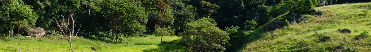
The Forest That Feeds the Coast
The Atlantic Forest that survives on the Mantiqueira's steep slopes is doing ecological work far downstream. Araucaria pines, the tall umbrella-shaped conifers that once dominated southern Brazil, still grow here and still feed the wildlife that depend on their pinion nuts. Bromeliads cling to the trees, not parasites but sky gardens collecting their own food from rain. Yellow ipê trees bloom in late winter when the branches are still bare, then leaf out in summer. The quaresmeira produces the purple and pink flowers that define the Lenten season. Maned wolves cross the ridges at night - solitary, canine, their howls traveling for kilometers. Capybaras graze near the streams. The waters leaving these hills feed Belo Horizonte, São Paulo, and Rio de Janeiro, and the rapid urbanization of those capitals means the protection of the Mantiqueira is not a matter of scenery. It is a matter of drinking water for tens of millions of people.
From the Air
The Serra da Mantiqueira stretches roughly from 22.0 to 23.0 degrees south and 44.5 to 47.0 degrees west, across southern Minas Gerais, northern São Paulo, and western Rio de Janeiro. Center coordinates 22.42 degrees south, 44.85 degrees west. Peaks rise to over 2,700 m; Pico das Agulhas Negras at 2,792 m is the highest point. Recommended viewing altitude 10,000-14,000 ft for terrain clearance; the BR-354 highway to the Itatiaia plateau reaches 2,450 m. Principal towns visible include Campos do Jordão, Itatiaia, Visconde de Mauá, and Penedo. Weather is critical: valley fog is common in winter mornings, afternoon thunderstorms in summer. Nearest airports are São Paulo Guarulhos (SBGR) to the south and Belo Horizonte Confins (SBCF) to the north.
Nearby Stories
- Itajuba 11 km away
- Campos do Jordao 26 km away
- Basilica of Our Lady of Aparecida 46 km away
- Cambuquira 58 km away
- Ibitipoca State Park 63 km away
- Varginha UFO Incident 65 km away
- Miguel Pereira 85 km away
- Christ the Redeemer: The Statue Built from Soapstone Carried Up a Mountain 116 km away