The Great Dayak River
The language spoken along this river is related to Malagasy, the tongue of Madagascar -- separated by five thousand kilometers of Indian Ocean but connected by the ancient Austronesian migrations that scattered people across half the planet. The Kahayan River, known also as the Great Dayak River, is Central Kalimantan's second-longest waterway, meandering 658 kilometers from the mountains in the north to the Java Sea in the south. Along its banks, the Dayak people have panned for gold for centuries, practiced the Kaharingan faith that blends ancestor worship with animism, and built longhouses from ironwood that can stand for generations. The river has sustained all of this. Whether it can continue to is an open question.
From Mountains to Mangroves
The Kahayan originates in the Schwaner Mountains, the forested spine that runs along Central Kalimantan's northern border. From there it snakes southward through 658 kilometers of plains, its path so tortuous with meanders that the river frequently shifts its bed. Tidal effects push saltwater 50 to 80 kilometers inland from the coast. The provincial capital, Palangka Raya, sits on its banks, and the river remains the primary artery for communities that roads have not yet reached. A study of the Kahayan found 28 fish species along its main channel, 44 in the connected Danau Sabuah lake, and 12 in traditional fish ponds -- diversity sustained by the riparian wetlands that serve as critical spawning grounds. But fishermen report declining yields, year after year, as water quality deteriorates.
People of the Longhouse
Three Dayak tribal groups dominate the Kahayan region: the Ngaju, the Ot Danum, and the Ma'anyan. Their differences map roughly onto geography. The Ot Danum remain in the upstream reaches of the Kahayan, Barito, and Kapuas rivers, preserving a way of life that would be recognizable to their ancestors. Many still live in longhouses, subsisting through hunting, fishing, and slash-and-burn agriculture. Village elders practice traditional medicine and mark their status with intricate body tattoos and heavy ear adornments. The Ngaju have migrated downstream over generations, settling in the mixed-population towns of the lower river, where they live alongside Javanese, Batak, Bugis, Banjarese, Chinese, and over a dozen other ethnic groups. They speak languages of the Barito family -- a linguistic thread that, remarkably, connects them to speakers of Malagasy in distant Madagascar.
Faith at the River's Edge
The traditional religion of the Kahayan Dayak is Kaharingan, a faith that weaves together ancestor veneration, animism, and belief in spiritual forces that inhabit the natural world. Its most important ceremony is the Tiwah, a secondary funeral lasting up to thirty days. The bones of the deceased are exhumed, cleansed, and placed in a sandung, a carved bone house, so that the spirit may watch over the village. Buffaloes, cows, pigs, and chickens are offered to the spirits and deities. In 1980, the Indonesian government classified Kaharingan as a form of Hinduism -- a bureaucratic compromise in a nation that required citizens to profess one of six recognized religions. The Dayak accepted the classification pragmatically, though Kaharingan's roots lie far from the Ganges.
Gold Dust and Mercury
People have panned for gold in the Kahayan for centuries, swirling river sediment in wooden dishes to catch the bright flecks carried down from mountain veins. In 1997, test drilling by a consortium of Canadian and Indonesian companies confirmed in-situ gold resources of at least 3.4 million ounces. The announcement transformed the upper river. A large number of informal prospectors now undertake alluvial operations throughout the river system, and more than 2,000 illegal miners may converge on a site when word of a gold find spreads. Even hard-rock miners transport their ore to the river for processing. The cost is measured in mercury: across Indonesia, nearly 180 tonnes of the toxic metal are released into the environment annually. The Kahayan carries its share downstream, past the villages whose residents drink its water and eat its fish.
A Forest That Forgot How to Flood
The lower Kahayan once flowed through a vast expanse of peat swamp forest, an ecosystem where tropical trees stood on a spongy layer of partly decayed plant material twelve meters deep. The 1996 Mega Rice Project aimed to convert a million hectares of this swamp into rice paddies by digging more than four thousand kilometers of drainage canals. The canals did not irrigate. They drained. Forests that had flooded two meters deep in the rainy season dried out completely. The abandoned project left behind drying peat that ignites with devastating regularity, sending haze across Southeast Asia. Sulphuric acid now leaches from the decomposing peat into the canal system, flowing into the Kahayan up to 150 kilometers from the river's mouth. Nearby, the Sabangau Forest -- 150,000 hectares of peat swamp between the Kahayan and Sabangau rivers -- holds on. Its western section is now protected as a national park, offering some hope for the orangutans who can no longer cross the Sabangau River through continuous forest. The eastern section remains designated for agriculture, though no one is trying to farm it anymore.
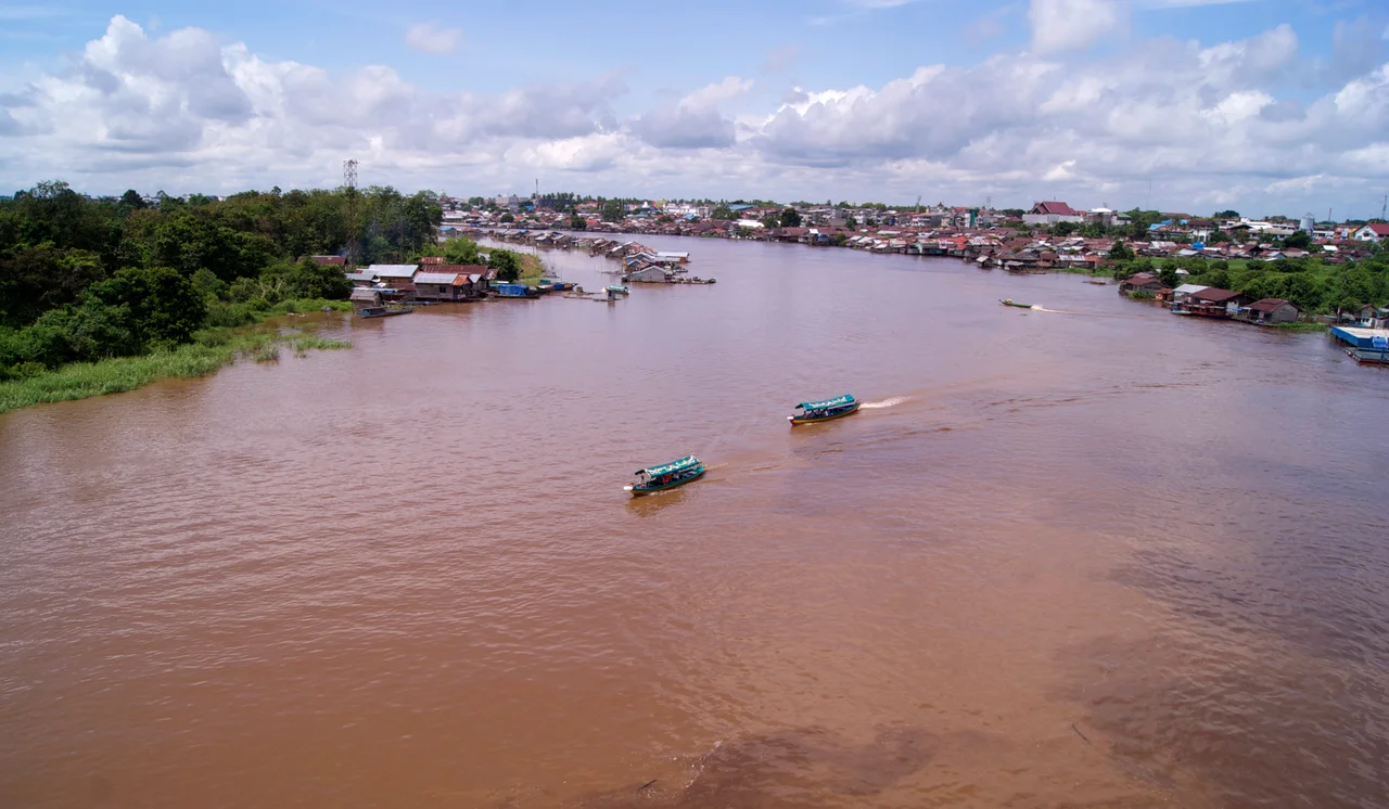
From the Air
The Kahayan River is visible as a prominently meandering brown waterway running roughly north-south through Central Kalimantan at approximately 2.20S, 113.92E. The river passes through the provincial capital Palangka Raya, served by Tjilik Riwut Airport (WAGG). From altitude, the extreme meanders and frequent oxbow lakes are distinctive features. The lower reaches show degraded peatland with visible canal networks from the Mega Rice Project. The Sabangau Forest lies between the Kahayan and Sabangau rivers to the southwest. During dry season, smoke from peat fires may significantly reduce visibility along the entire river corridor.
Nearby Stories
- The Night Kasongan Market Burned 19 km away
- The Million-Hectare Mistake 30 km away
- The River of Four Names 94 km away
- Sixty Seconds Over Banjarmasin 105 km away
- Oil, Empire, and the Fight for Borneo 215 km away
- Kyai Gede Mosque 235 km away
- The Bay That Burned 255 km away
- The Monsun Boat That Almost Outlasted the War 303 km away