La Pita
The discovery was an accident. Workers were building an access road into a mountainous stretch of Colombia's Boyaca department when they descended toward the Rio Minero and noticed something odd in the rock face: a yellow patch of earth, surrounded by the black carbonate-altered shales of the Muzo Formation. They called the spot Amariallal, the yellow place. Colombian miners know what those colors mean when they appear together. Inside that geology, somewhere in the tilted veins of ancient sediment, sits the world's finest emerald. La Pita mine opened. At times it has produced more than eighty percent of all Colombian emeralds, which is to say, more than eighty percent of the world's best green stones.
The Western Belt
Colombia's emerald geography divides into two main zones, the eastern belt and the western belt, corresponding to ancient sedimentary formations in the foothills of the Eastern Cordillera. La Pita sits in the western belt, near the municipality of Maripi in Boyaca department, within a cluster of mines that includes the legendary Muzo mine (once called Puerto Arturo) to the south. Colombian emeralds are prized above all others for a specific reason. The geological conditions that formed them, hot hydrothermal fluids pushing through the Muzo Formation's carbonate-rich shales, combined with unusually low iron content in the local rock, produced stones of a purer, deeper green than emeralds from Zambia, Brazil, or anywhere else. The color is so distinctive that gemologists describe other emeralds by how close they come to Colombian green. La Pita and its neighbors pull those stones from the ground.
What the Tunnel Hits
The entrance to La Pita opens at a ravine near the Rio Minero, at the base of a mountain. The tunnel runs approximately 500 meters inward until it intersects the principal fault line running along the length of the property. That fault is the Rio Minero Fault, and it is the reason the mine exists. Emeralds here form along calcite veins that run oblique to the fault, cutting through the footwall shales of the Muzo Formation. The veins are typically one to several meters thick, oriented at various angles. Where two vein sets cross each other, miners have learned over decades, the stones tend to be better: sometimes clearer, sometimes larger, sometimes both. The geometry of an emerald deposit is not random. It is the signature of how hot, mineral-rich fluids moved through brittle rock millions of years ago. La Pita's workers read that signature every day.
The Muzo Formation
The Muzo Formation itself dates to the early Cretaceous period, roughly 130 million years ago, in the Hauterivian-Barremian stages. It outcrops across the sector at Las Pavas, Penas Blancas, Coscuez, and Velez, appearing too in Chiquinquira and La Palma. In La Pita, the formation is generally calcareous, a sequence of dark gray calcareous claystones with limestone concretions, interspersed with sandstones and siltstones. Pyrite and calcite veins run through the rock. Towards the middle of the sequence, the rock becomes brecciated and mineralized, with calcite veins and sheets of oxidized sulfides. This is where emeralds live. The zone of hydrothermal breccia sits just above the calcareous base, reaching about thirty meters thick at La Pita and up to fifty meters at the nearby Totumos mine. Some of these stones were locked in the earth before dinosaurs went extinct. Geology gave them plenty of time.
The Contracts, the Canadians, the Families
La Pita is privately owned by the Colombian company Zuliana De Esmeraldas Ltda, which holds a thirty-year concession agreement registered with the National Mining Agency of Colombia. The title grants exclusive rights to extract, process, transport, and ship the minerals. But the operational history of the mine has been more tangled than that bureaucratic line suggests. In recent years, La Pita entered and withdrew from an agreement with the publicly traded FURA Emeralds Inc. A Canadian company then entered a non-binding agreement and failed to close. In 2016, a third foreign partner was negotiating full operation and a stake in the holding company. The negotiations have continued in cycles. Colombian emerald mining historically belonged to a handful of families who held informal control of the territory, and the transition to publicly traded foreign investment has been slow, uneven, and politically sensitive.
Security, Old and New
The Colombian emerald belt has a reputation for violence. For decades through the 1980s and 1990s, rival families and guerrilla groups fought for control of the mines in what was called the Green Wars. Mine bosses built private armies. Bodies turned up in rivers. The worst of that era, by nearly every account, is over. The violence is now described by local sources as a faint memory of the past, and the mining region today is described as community oriented and safe. Security at La Pita is a collaboration between private security teams, the National Police of Colombia, and the National Armed Forces of Colombia. Their presence extends into community social projects: building homes, aqueducts, maintaining roads. Inside the mine, security is a different story. The mine has four points of access. Emeralds still wind up in the tailings with some regularity, of variable quality. The logistics of sorting what comes out of the tunnel from what should come out of the tunnel remains an ongoing challenge.
Why Green Matters
The finished stones sold at auction in Bogota, Zurich, or Hong Kong do not come with the mine attached. A buyer sees only the gem. But the color, the clarity, and the shape of a Colombian emerald were all decided in the Muzo Formation. A calcite vein cracked, hot fluid rushed in, beryllium and chromium crystallized at a specific temperature and pressure, and a hexagonal prism of beryl formed with just enough chromium to absorb every wavelength except the deep green. Break the rock wrong and the gem shatters. Break it right and a workshop in Bogota cuts and polishes a stone that will travel to a ring on somebody's hand halfway around the world. La Pita sits at the start of that supply chain. Workers there, mostly men from surrounding villages, know the mine's oblique veins the way farmers know their fields. The mine does not advertise. Its product does.
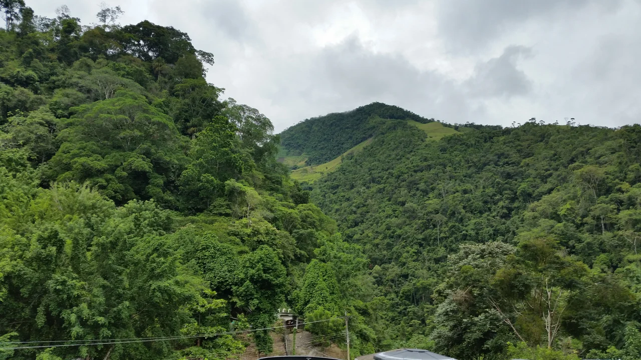
From the Air
Located at 5.57 degrees North, 74.07 degrees West, in the western emerald belt of Colombia's Boyaca Department, near Maripi. The mine sits at roughly 1,000 meters elevation along the Rio Minero valley, at the edge of the Cordillera Oriental (Eastern Cordillera). The town of Muzo, home to the legendary Muzo mine, is approximately 20 km south. Bogota lies roughly 150 km southeast; Tunja, the Boyaca capital, roughly 90 km east. Nearest airport: Gustavo Rojas Pinilla (SKGP) at Tunja for small aircraft; El Dorado International (SKBO) at Bogota for commercial traffic. Recommended viewing altitude: FL100 to FL150 to observe the terrain of the western emerald belt, a mountainous zone of steep ridges and deep river valleys. The Rio Minero cuts a visible gorge along the property. Afternoon convective weather is common; mornings offer cleaner visibility.
Nearby Stories
- Tunja 13 km away
- Hacienda Napoles 25 km away
- Zipaquirá 28 km away
- Casa del Fundador Gonzalo Suarez Rendon 46 km away
- Barichara 97 km away
- El Penon de Guatape 104 km away
- Manizales 111 km away
- Operation Jaque 367 km away