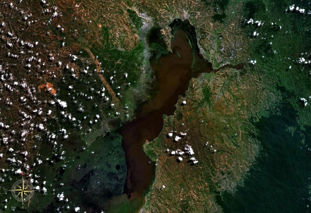

Lake Alaotra
There is a lemur that never touches a tree. It is born in the reeds, sleeps in the reeds, swims between the reeds when it must, and dies in the reeds - the only primate on Earth tied entirely to a marsh. The Malagasy call it bandro. It lives in one place and one place only: the wetlands fringing Lake Alaotra, the largest lake in Madagascar, set high on the island's central-northern plateau. The open water spreads across some 900 square kilometres, but it is shrinking and shallowing year by year, and the fate of the bandro is bound up with the fate of a landscape that feeds much of a nation even as it disappears.
The Rice Bowl of Madagascar
Alaotra is not wilderness. The fertile plain wrapped around the lake is the single most important rice-growing region in a country where rice is life - eaten at nearly every meal, woven through the language and the economy alike. The basin and its wetlands sprawl over more than 7,000 square kilometres, a patchwork of open water, reedbeds, marsh, and flooded paddy. In 2003, the whole system was recognised under the Ramsar Convention as a wetland of international importance, an acknowledgement that what happens here matters far beyond the lake's muddy shores. But the same fertility that makes Alaotra a breadbasket also makes it a battleground, because every new paddy carved from the marsh is a piece of habitat taken from something that lived there first.
The Lemur in the Reeds
The Alaotra gentle lemur is a small, grey-brown bamboo lemur that evolved to do something no other lemur does - abandon the forest entirely for a life among cyperus and reed. The marsh is its whole world. That makes it exquisitely vulnerable, because its world can be burned in an afternoon. Pressure to open new rice fields drives locals to torch the reedbeds, and the bandro's range has collapsed to barely 220 square kilometres of surviving marsh. The population told the story in a decade: roughly 7,500 animals counted in 1994 fell to around 3,000 by 2001, a drop of 60 percent, lost mostly to vanishing habitat and partly to hunting. Conservationists now race to give the bandro a future, but every dry-season fire on the lake's edge is a wager against it.
What the Lake Has Already Lost
Alaotra keeps a quiet ledger of extinction. The Alaotra grebe - a small diving waterbird found nowhere else - was last reliably seen in 1985 and declared extinct in 2010, undone by introduced predatory fish that ate its young and nylon gill nets that drowned the adults as they dived. The Madagascar pochard, a duck that once paddled these waters, vanished from the lake entirely and now survives only as a tiny remnant population rescued elsewhere on the island, ranked among the rarest birds in the world. Even the lake's fishery tells of upheaval: a tilapia introduced from the mainland in 1954 had taken over nearly half the catch within three years. Alaotra is a place where the consequences of small decisions - a fish released, a net cast, a reedbed burned - have already played out to their ends.
A Lake Filling With Its Own Hills
The slow crisis at Alaotra is written in mud. The hills ringing the lake were once forested; cleared for farmland, their bare slopes now bleed soil with every rain. That eroded earth pours into the lake and settles, so the water grows shallower season by season - in the dry months, parts of this great lake stand barely 60 centimetres deep. The Ambato River both feeds and drains the basin, eventually carrying its waters more than 380 kilometres to the Indian Ocean. Stand on the shore at the end of the dry season and you can read the whole story at once: the wide flat water, the green wall of reeds where the bandro hides, the geometric paddies pressing in, and beyond them the scarred red hills slowly washing themselves into the lake.
From the Air
Lake Alaotra lies at roughly 17.5 degrees south, 48.5 degrees east, on Madagascar's central-northern plateau at around 750 metres elevation. From the air it is unmistakable - the island's largest body of open water, a broad shallow lake rimmed by a green halo of reedbed and marsh, then a geometric quilt of rice paddies, then eroding red-earth hills. The nearest airfield is Ambatondrazaka Airport (ICAO: FMMZ) on the lake's southwestern side; Toamasina Airport (ICAO: FMMT) lies to the east on the coast, and Antananarivo's Ivato International (ICAO: FMMI) is the principal gateway to the southwest. The lake makes an excellent visual navigation landmark. Recommended viewing altitude 6,000-8,000 feet; haze from agricultural burning can reduce visibility in the dry season.
Nearby Stories
- Toamasina 73 km away
- Battle of Tamatave 99 km away
- HMS Serapis (1779) 107 km away
- Ambohimanga 115 km away
- Andasibe-Mantadia National Park 120 km away
- Ankarafantsika National Park 151 km away
- Antananarivo 161 km away
- Nosy Boraha 170 km away