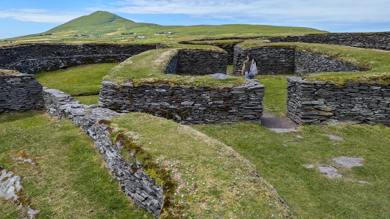

Leacanabuaile
The Irish name tells you what this place once was: Leacanabuaile, the hillside of the milking-place. Strip away the romance of stone ringforts and you find a farmer, sometime in the 9th century, who needed a defended yard for his cows and his family, and who built one out of every loose stone he could lift from the surrounding fields. The walls he raised are still standing thirteen hundred years later. They are over two metres high, three and a third metres thick, and they hold three intact stone beehive huts and a covered underground passage in their interior. It is not the largest ringfort in Ireland by a long way, but it might be the most legible.
A Farmstead, Not a Castle
We are used to the word fort meaning defence against armies, but the cashel at Leacanabuaile was something more modest and more practical. The 9th and 10th centuries in this part of Kerry were a time of small landholders, cattle raids by neighbours, and occasional Viking trouble along the coast. The thick stone walls of a cashel kept livestock secure overnight, kept opportunists out, and signalled the householder's status. The site sits on a low rise with steep grassy slopes on three sides, so the only practical entrance is from the east, which is where the original gateway still lies. Inside is enough space, about thirty metres across, for a working family compound of huts, byres, and a hearth, plus the animals that meant survival.
Three Beehive Huts and a Souterrain
Step through the eastern gateway and you find the interior arrangement that gives Leacanabuaile its character. There are three stone beehive houses, the corbelled drystone domes that western Ireland built for centuries because they suited the available stone and the available weather. The largest of them is intact enough to walk into. There is also a souterrain, an underground passage cut into the rock and lined with stone slabs, of the kind common in early medieval Ireland. Souterrains served two purposes, both useful: cold storage for dairy and meat, and a place of last resort if raiders came. They were narrow, low, and easy to defend from inside.
What the 1939 Dig Found
Excavated in 1939 and 1940, the cashel gave up the small objects of an ordinary working life. The list is plain and revealing: iron knives and pins, bone combs, fragments of bronze, a millstone, scraps of lead. Nothing aristocratic. Nothing that would make a museum's headline display. But every object speaks of the day-to-day labour of a household that lived here, ground its grain here, combed its hair here, and patched the bronze cookware that fed the family. The finds dated from the 9th and 10th centuries, the brief working life of the cashel before its occupants moved on or simply stopped maintaining the walls.
Cahergal, Just Next Door
Leacanabuaile does not stand alone. Three kilometres northwest of Cahersiveen, and only a short walk from its slightly larger and more famous neighbour Cahergal, this is one of a small cluster of stone cashels that survive remarkably well in this corner of Kerry. The two forts together draw walkers up from the road through gentle pasture, and on a clear day the view from the parapet of Leacanabuaile takes in the inlet at Ballycarbery and the slate-coloured outline of Valentia Island beyond. The cows still graze around it. The hillside is still, in a small way, the milking-place that named it.
From the Air
Leacanabuaile sits at 51.96 N, 10.26 W on a low rise about 3 km northwest of Cahersiveen, on the Iveragh Peninsula. Best viewed at 1,500-3,000 ft. The cashel appears as a circular dry-stone enclosure roughly 30 m across, with Cahergal fort visible immediately to the southeast. Both forts lie inland of Ballycarbery Strand and the inlet that opens onto Valentia Harbour. Nearest airport is Kerry (EIKY), 35 nm northeast. The Atlantic coast immediately west can be cloudy, but the inland hills around Cahersiveen often stay clear.
Nearby Stories
- 1955 RAF Shackleton aircraft disappearance 3.8 km away
- Ballynavenooragh 5.4 km away
- French Expedition to Ireland (1796) 9.4 km away
- Tralee 12 km away
- Uragh Stone Circle 18 km away
- The Laki Eruption: The Volcano That Changed World History 1385 km away
- The Northern Lights: The Sky Show That Vikings Thought Was Bridge to the Gods 1487 km away
- Sao Miguel 1921 km away