
Llyn Cerrig Bach
William Owen Roberts was the head groundsman at RAF Valley in 1942, and his immediate problem was that the Spitfires and Hurricanes needed a longer runway. Anglesey was a key piece of the Battle of the Atlantic; the Coastal Command base on the island's western edge was being expanded to handle bigger aircraft. While clearing peaty ground beside a small lake called Llyn Cerrig Bach for the runway extension, Roberts hit metal - a heavy iron chain. He pulled it out and showed it to someone who knew what it was. What it was, was a slave chain. And it was about to lead archaeologists to one of the greatest Iron Age treasure hoards in Britain.
The Chain That Was Not for Cattle
The chain was a gang chain - iron links and collars designed to fasten prisoners or slaves together by the neck. It was unmistakably Iron Age in style, two thousand years old. The archaeologist Cyril Fox, who came to Anglesey to study the find, made the case that this was the physical evidence behind a Roman story everyone had read but no one had ever proven. Tacitus, the Roman historian, wrote that when Suetonius Paulinus crossed the Menai Strait in 60 CE to subdue Anglesey, his legions found a place of horror: druids and "a troop of frenzied women" defending sacred groves, where the Britons "deemed it indeed a duty to cover their altars with the blood of captives and to consult their deities through human entrails." If Tacitus was right, the gang chain at Llyn Cerrig Bach may have held the people whose blood was used.
What Was Thrown Into the Water
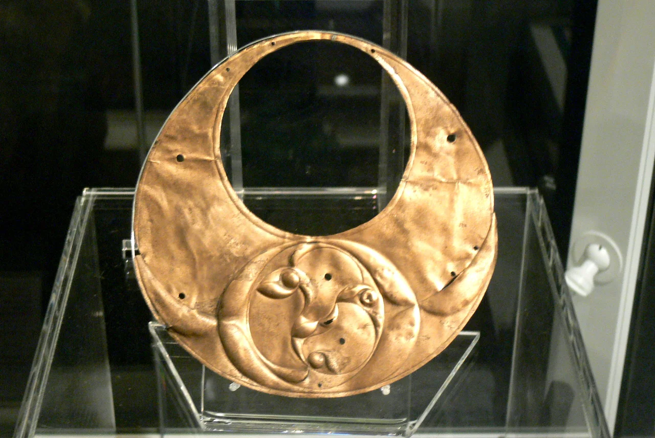
Once the chain had been identified, the search of the surrounding peat began in earnest. The chain turned out to be the beginning. Over 150 Iron Age metal objects came out of the lake bed in total - eventually 181 artefacts, by the National Museum of Wales count - making this the most important Iron Age votive deposit ever found in Wales and one of the most important in the entire British Isles. Seven swords. Six spearheads. Fragments of a shield. Part of a bronze trumpet. A second gang chain. Iron wagon tyres and horse gear. Blacksmith's tools. Two cauldrons in pieces. Iron currency bars used for trading. Animal bones. And among them, a magnificent crescentic bronze plaque in the shape of a gold lunula, decorated with the swirling triskele patterns of La Tene Celtic art - one of the masterpieces of early Celtic metalwork.
A Sanctuary at the Edge of the World
The objects had been deliberately thrown into the lake over a long period - votive offerings to the gods or spirits of the water. The collection covers several centuries, which means the practice continued generation after generation. Llyn Cerrig Bach was a sanctuary. To stand at the lake today is to look at a small body of water, about 1.8 acres, not even one of the larger lakes on the island. To stand there in the Iron Age was to stand at a sacred threshold - the kind of place Celts believed connected the living world to the otherworld below the surface. The variety of objects suggests both warriors and craftsmen made offerings here. The slave chains suggest the offerings sometimes included human lives. Whether Llyn Cerrig Bach was a major druidic centre - perhaps the one Tacitus described - is still argued. The objects themselves do not settle the question. They only confirm that for several centuries this small lake mattered enormously.
What the Lake Holds Now
Most of the finds went to the National Museum of Wales in Cardiff, where they remain part of the permanent collection. From November 2012 onwards a substantial portion has been on long-term loan to Oriel Mon, the museum and gallery in Llangefni, returning the artefacts much closer to where they were buried. RAF Valley still operates on the runway whose construction triggered the discovery; the base today trains British military pilots in fast-jet flight on Hawk aircraft. From the air, the lake is a small dark oval set in the heathy ground west of the runway, a feature you would not look at twice. Beneath that unremarkable water lay one of the most consequential archaeological discoveries in modern British history, hidden until a wartime groundsman went to extend a runway and brought a slave chain up into the daylight.
From the Air
Coordinates 53.259°N, 4.540°W on the west of Anglesey, immediately adjacent to RAF Valley (EGOV, runway 14/32). The lake sits in heath and peatland west of the airbase runway and is most clearly visible in aerial photography rather than from cockpit height. The site is restricted civilian airspace due to active military operations at RAF Valley. Caernarfon Airport (EGCK) lies 25 km southeast across Caernarfon Bay. Best viewed only in aerial imagery or by careful overflight outside restricted hours. Holyhead Bay and the Irish Sea stretch immediately to the west.
Nearby Stories
- Wakestock 1.7 km away
- Trefriw 3.8 km away
- Irish Sea 8.7 km away
- Irish Sea Bridge 20 km away
- East–West Interconnector 30 km away
- Machynlleth 36 km away
- HMS Tyler 41 km away
- New Brighton Lifeboat Station 54 km away