.jpg)
Loanhead of Daviot Stone Circle
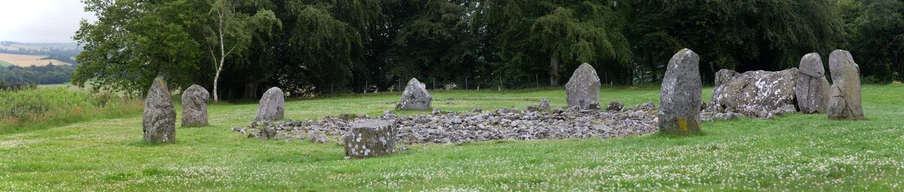
The recumbent stone lies on its side, splitting lengthways along a natural weakness in the granite, looking now like two parallel slabs in the southern arc of the circle. It is angled slightly to the south, and the azimuth from the centre of the ring falls somewhere between 196 and 202 degrees - oriented, the archaeologists believe, toward the southern moon at its lowest standstill. On either side stand the flankers, tall pillar-stones marking the recumbent's place. Around them, eight orthostats complete the ring, twenty-one metres across. This is the Loanhead of Daviot, one of only a handful of recumbent stone circles in Scotland that still has every original stone in place. It was built in the early Bronze Age, on a ridge that catches the southern sky cleanly, and it has been receiving the dead ever since.
A Distinctly Northeastern Design
Recumbent stone circles do not exist anywhere else in Britain, except in a handful of axial circles in southwest Ireland that may share their ancestry. They cluster in lowland Aberdeenshire - perhaps eighty rings total - all built to the same essential plan: a ring of upright orthostats, with one massive recumbent stone lying on its side along the southern arc, between two tall pillar flankers. The design seems to descend from the Clava cairns of Inverness-shire and may have evolved into Ireland's axial circles in turn. What unites them all is an astronomical interest in the southern sky - specifically the path of the moon at its major standstill, the eighteen-and-a-half-year cycle when the moon rises and sets at its most extreme southern points. Stand at the centre of a recumbent circle and look across the recumbent to the horizon, and you are looking at the moon's lowest passage. These were calendrical machines as much as ceremonial spaces.
Building the Ring
Whoever built Loanhead chose the site for its view. The circle sits on a ridge above the village of Daviot in lowland northeast Scotland, with a long open horizon to the south. The eight orthostats on the eastern perimeter step down in height from south to north; those on the west are roughly equal but, because they stand on sloping ground, appear graded to the eye. The recumbent itself was originally about 3.4 metres long and the taller back slab still rises 1.8 metres above the artificially-laid platform of boulders that holds the southern setting. Cup marks - the small round depressions that Bronze Age people carved into stones across the British Isles for reasons we still do not fully understand - appear on the eastern flanker (one mark, low and central) and on the orthostat beside it (twelve shallow cups). The next stone bears two more. Whatever the cup marks meant, they were chosen carefully and placed precisely.
The Dead Beneath
When Howard Kilbride-Jones led the major excavation of 1934, he came expecting to find the circle's central cairn and perhaps a few burials. What he uncovered toward the end of the season changed the site's meaning entirely. At the eastern edge of the excavation lay a cist, internal dimensions about half a metre, containing an incense cup and cremated human bones. The next season he traced the cist to the northern edge of a sunken stone wall about ten metres across - more likely a burnt-down timber palisade packed with stone. The wall enclosed a cemetery whose existence nobody had suspected. Inside, between roughly 2000 and 1000 BCE, successive pyres had reduced at least thirty-one people to ash and bone, scattered among twelve urns and thirteen pits. The cremation deposits have been lost since excavation, so no carbon dating has ever been possible. But the numbers stand: at least thirty-one human lives, ended over a thousand-year span, burnt and buried just east of the stones.
What You See Now
Some of what stands at Loanhead today is restored rather than original. The western flanker had its top replaced in 1934-35; the eastern flanker, which had fallen, was reset in its original socket. In 1989 stones that had filled the centre of the cairn were removed, exposing an internal court 4.3 metres across - though archaeologists now debate whether such a court existed when the site was first built, or only briefly around 1000 BCE. Frederick Coles made the first detailed record in 1901, when only four orthostats still stood and the recumbent showed only its upper portions. The site became a scheduled monument in 1925 and passed into state guardianship in 1933, which is why so much of it survived to be studied. Pottery sherds across the site span from the Early Neolithic to the late Bronze Age, suggesting people came back to this ridge over more than two thousand years. The reasons they came are largely lost. The ring remains.
From the Air
Loanhead of Daviot sits at 57.35N, 2.42W, on a low ridge about a mile northwest of Daviot village. From altitude, look for the open ridge-top setting with clear views south toward the Garioch valley and the long Bennachie ridge dominating the western horizon. Aberdeen International (EGPD) lies 16nm southeast. Best viewed at 2,000-3,500 ft AGL in clear conditions; the circle itself is small (21m across) but the ridge it crowns is visible against the lower farmland on either side. Look for the parallel field boundaries that frame the protected enclosure.
Nearby Stories
- Tomnaverie Stone Circle 2.5 km away
- Pennan 2.9 km away
- Cullen Viaduct 4.1 km away
- Drum Castle 4.9 km away
- Auchindoun Castle 17 km away
- German submarine U-58 (1938) 65 km away
- HMS Daring (H16) 138 km away
- Longstone Lighthouse 165 km away