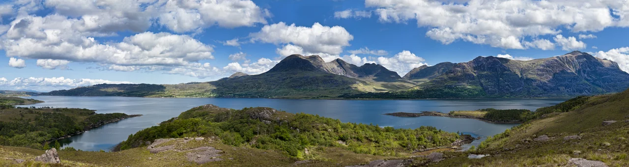

Loch Torridon
The rocks here are older than oxygen. The Lewisian gneiss beneath Loch Torridon's mountains formed three billion years ago, before plants existed, before complex life. The Torridonian sandstone piled on top is younger but still ancient - around a billion years old, crowned in places by white Cambrian quartzite. Stand on the shore of Upper Loch Torridon, look up at Liathach or Beinn Alligin, and you are looking at geological time made visible: tier upon tier of stone, each layer separated from the next by hundreds of millions of years that scrolled past before anything alive saw them.
Glacier's Work
Loch Torridon is a sea loch carved by ice. The glacier that ground out this fifteen-mile gouge in the western Highlands left behind a fjord-like trench with two sections - Upper Loch Torridon to the east, joining Loch Shieldaig at Rubha na h-Airde Ghlaise, and the main western basin of Loch Torridon proper running out to the Inner Sound. The mouth lies between Rubha na Fearna to the south and Red Point to the north. Smaller inlets - Loch a' Chracaich, Loch Beag - notch the southern shore of the outer loch. Islets dot the water. Eilean an Inbhire Bhàin, Eilean Dùghaill and Shieldaig Island sit in Loch Shieldaig; tidal Eilean à Chaoil and Eilean Cnapach in Upper Torridon; Eilean Mòr, Eilean Tioram and the Sgeirean - skerries - further out. The Gaelic name Thoirbhearta shares a root with Tarbert, indicating a place where boats were once dragged overland.
Among the Oldest Rocks in Britain
The Torridon Hills are not the highest mountains in Scotland but they are arguably the most dramatic. Liathach rises like a fortress wall, its terraced quartzite tops visible for miles. Beinn Eighe gleams white-grey in the right light. Beinn Alligin shows its serrated ridge of pinnacles, the Horns of Alligin, to anyone climbing from the loch. All three are over 900 metres. What makes them special is not height but composition: red and chocolate-coloured Torridonian sandstone, laid down by rivers and lakes a billion years ago when this part of the world was a barren landscape near the equator. The white caps on some summits are Cambrian quartzite, deposited some 500 million years later. Beneath all of it sits Lewisian gneiss, the basement rock of northwest Scotland - three billion years old, hardened by metamorphism, scoured smooth by ice. The Torridon Hills sit at the cusp of unimaginable time.
Villages on the Shore
Torridon village stands at the head of the loch, ringed by the Torridon Hills. Walk down to the shore from the road and the mountains close in around you like cathedral walls. Diabaig and Wester Alligin and Alligin Shuas sit to the north along the loch's bend, and Shieldaig - meaning herring bay - stands to the south on its own small loch, its single curve of white cottages still pointed at the water. Redpoint marks the northern edge where Loch Torridon meets the Inner Sound. None of these are large. None ever were. The terrain does not allow it: too steep, too stone-strewn, too poor for anything beyond grazing and the sea. The 1999-2004 Scotland's First Settlers archaeological project found 129 new sites along Loch Carron and Loch Torridon combined - eight new ones on Torridon itself, suggesting the loch was actually quite intensively occupied in the Mesolithic. Of twelve caves and rockshelters examined, four showed evidence of human use. Prehistoric people, like modern ones, knew a good loch when they saw one.
Langoustines and Suspended Certification
Today Loch Torridon's economy runs on prawn and shellfish fisheries, salmon farms and industrial mussel production. The most distinctive catch is langoustine - the small clawed lobster known on Spanish menus as cigala and on French ones as langoustine, fished here by baited creels. Lines of up to 120 creels, each baited with herring or prawn, sit on the seabed for at least a day before the boats haul them back up. Most of the catch leaves the loch for Spain. Some sells locally to restaurants in Plockton and Ullapool. The fishery once held the Marine Stewardship Council's sustainable seafood certification, but the council suspended that certificate on 11 January 2011, after increased fishing pressure from creel boats that had not signed up to the voluntary code of conduct. The langoustines kept coming up. The certification stayed suspended.
Mountain Weather, Mountain Light
Loch Torridon is one of those places where the weather is the show. Cloud rolls in from the Atlantic and snags on Liathach's quartzite tops, then peels away to reveal the mountain still standing there, indifferent. Late afternoon light turns the Torridonian sandstone the colour of warm rust. Winter brings snow on the high tops and Northern Lights on the clearest nights, the same loch surface mirroring auroral green when the sky cooperates. Beinn Damh rises across Upper Loch Torridon from the village, and any climb that gets you above 500 metres opens out the entire Inner Sound, with Skye and Rona and Raasay arrayed to the west like a chart spread out for inspection. This is the kind of landscape that does not need anything added to it. It just keeps showing you what stone and water and weather can do when given a billion years to practise.
From the Air
Loch Torridon lies at 57.58 degrees north, 5.76 degrees west, running roughly east-west on the west coast of Wester Ross. Approach from the west offers the cleanest sight-line up the loch to Torridon village and the great mountain wall beyond - Liathach, Beinn Eighe and Beinn Alligin all over 900 metres. The mouth opens to the Inner Sound; Skye lies across the water to the southwest. No airfield on the loch itself - the nearest is Plockton (light aircraft only). Larger options: Inverness (EGPE) 80 nm east, Stornoway (EGPO) 70 nm northwest, Skye's Broadford strip about 25 nm south. Recommended viewing altitude 2,500-4,500 ft AGL to see the loch's full sweep and the mountain backdrop. Squalls common - the Torridon Hills make their own weather.
Nearby Stories
- Talisker distillery 1.7 km away
- Rua Reidh Lighthouse 3 km away
- Uig 3.5 km away
- Skye Bridge 4.7 km away
- Shiant Islands 7.7 km away
- Loch Broom 9.2 km away
- Glen Affric 18 km away
- Corrieshalloch Gorge 26 km away