
Lochaber Narrow Gauge Railway
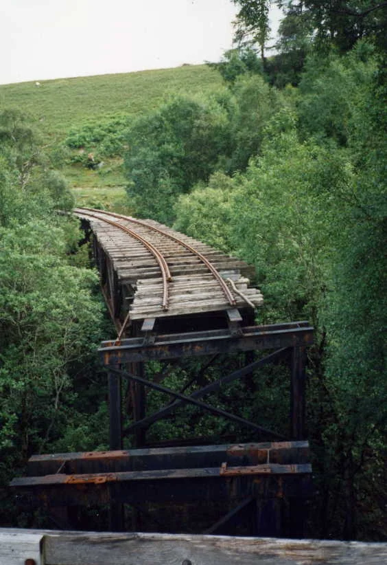
Drive the A82 north from Glen Coe today and you will pass under a steel railway bridge that no train has crossed since 1977. Look up. That bridge is one of the last visible fragments of what was once a 19-mile industrial railway that climbed from Fort William deep into the wilderness above Loch Treig, hauling men and materials to twenty-three separate tunnel faces hidden in the hills. They called it the Old Puggy Line. It existed for one reason: to drill a 15-mile water tunnel through solid rock so that water from Loch Treig could fall onto turbines at the British Aluminium smelter at Fort William. The aluminium produced went on to skin Spitfires in World War II. The railway that made it possible was an engineering improvisation of remarkable ambition, mostly forgotten, mostly gone, but its trace is still readable on the hillside if you know where to look.
Aluminium and the Hall-Héroult Problem
Aluminium does not come out of the ground as metal. It comes as bauxite, a clay-like ore whose properties were first understood in 1821. To produce the silver-white metal, you first refine bauxite into alumina by the Bayer process, then reduce alumina to aluminium by the Hall-Héroult process, which is an electrolytic reaction. The catch is that electrolysis consumes enormous amounts of electricity. In the 1890s, that meant hydropower, and in Britain that meant the Highlands. British Aluminium opened the country's first electrolytic smelter at Foyers, on Loch Ness, in 1896. World demand for aluminium rose fast, and a second smelter opened at Kinlochleven in 1908, powered by the Blackwater Reservoir. By 1918 the company wanted to expand further, but Kinlochleven simply did not have the space for the workers' housing the new plant would require. A revised scheme was authorised by the Lochaber Water Power Act of 1921: pipe the water of Loch Treig through 15 miles of tunnel to a brand-new smelter at Fort William.
The Brushwood Track
Construction of stage one began in the mid-1920s. The route ran from a new pier on Loch Linnhe up to the valve shafts at Loch Treig, climbing from 35 feet of altitude to over 800 feet in places. There was no road. There had to be a railway. The consulting engineers, Meik and Halcrow, specified one as a contractual requirement, with a bonus payable to the main contractor Balfour Beatty if the railway and a temporary power station at Monessie Gorge were completed in the first nine months. They earned the bonus. The route presented a series of awkward gradients. Base Camp at the smelter was at 35 feet. Adit 10, the first tunnel access point, was at 640 feet, only 2.5 miles away. A direct line would have required gradients of 1 in 22, far too steep for an adhesion locomotive. The solution was a switchback: 3.25 miles of climbing at 1 in 35 to a junction, then a branch running back along the hillside to the adit. Stretches of 1 in 30 and 1 in 25 were unavoidable. Further along, where the railway crossed peat bogs, the rails were laid on fascines, mats of bundled brushwood. The track flexed under load. The crews learned to live with it.
Twenty-Three Faces
The genius of the railway was that it let the tunnellers work the 15-mile bore from twenty-three different faces simultaneously. The main tunnel ran from Loch Treig to the smelter. The railway connected base camp to three intermediate shafts, seven adits, and the valve shafts at the loch. Each adit was a side passage where crews could enter the main tunnel and dig in two directions at once. There was also a separate two-foot-gauge railway inside the tunnel itself, used to haul spoil out and lining materials in. At shafts 1, 2, and 7, spoil was lifted out by hoists. The internal tunnel railway eventually grew to about 20 miles total length, almost as long as the surface line, before being removed when the bore was complete. Three teams of men, six to ten in each, worked outward from Base Camp, from the central point, and from Fersit at the upper end, levelling about 30 yards of railway formation per day with pickaxes and shovels. Bridge 15, over the Allt Leachdach, was a 54-foot steel span on concrete abutments. Bridge 27, near Adit 6, was a 40-foot span over the Allt Choimhlidh. Most other bridges were timber trestles, later rebuilt in steel using scrap from the smelter.
The Pier and the Closure
Stage one was completed in five years at a cost of £3 million, an enormous sum in the mid-1920s. The permanent pier at the mouth of the River Lochy was finished by the end of 1926, half a mile long, with a three-foot gauge railway running 1.75 miles from the pier through Inverlochy to Base Camp. The pier railway carried alumina in from cargo ships and finished aluminium ingots out, bound for Runcorn on the Manchester Ship Canal. The original route was eventually replaced with a longer one to make way for housing, crossing the West Highland Railway on a plate-girder bridge that still stands. The intention had always been to electrify the permanent pier railway with overhead lines, but it never happened. The Upper Works Railway was retained after construction ended and used for tunnel maintenance for decades. In 1930 the Treig-Laggan branch line was added, crossing the West Highland Railway at Fersit on a 26-span timber trestle that was later filled in to form an embankment. In October 1971, heavy rainfall washed out a 70-foot gap in the Upper Works Railway. Rather than repair the track, British Aluminium and the Forestry Commission agreed to build access roads instead. The line limped on for another six years. It finally closed in 1977. Two locomotives and two speeders were left stranded on the far side of the breach, never recovered. Brazil class 0-4-2ST 'Sir Murray Morrison' was rebuilt by Alan Keef and worked on the Cavan and Leitrim Railway in Ireland from 1994. The bridges are mostly still in place, slowly weathering on the hillside.
From the Air
The former Lochaber Narrow Gauge Railway ran from approximately 56.82°N, 4.72°W (Loch Treig) west to Fort William on Loch Linnhe at the foot of Ben Nevis. The 15-mile water tunnel beneath, still in active use by the Fort William smelter, runs roughly east-west along the same line. From the air, look for the chain of small access bridges crossing the slopes south of the West Highland Line between Tulloch and Fort William. The smelter complex sits at the eastern edge of Fort William between the town and the foot of Ben Nevis (1,345 m, EGPF airport visible 65 nm to the south). Nearest airports: Glasgow (EGPF) approximately 70 nm south, Inverness (EGPE) approximately 55 nm north-northeast. Recommended viewing altitude 4,000-6,000 ft AGL to follow the railway alignment along the south side of the Spean valley.
Nearby Stories
- Battle of Bun Garbhain 3.5 km away
- Fort Augustus Abbey 4.2 km away
- Battle of Glen Shiel 5.4 km away
- Castle Stalker 7.7 km away
- Fortingall 10 km away
- Monadhliath Mountains 14 km away
- Falls of Bruar 20 km away
- Battle of Dalrigh 20 km away