Long Ravine Trestle: Where the Railroad Crossed Itself
Every day, somewhere around mid-morning, the westbound California Zephyr rolls across a pair of steel bridges near Colfax, California, and most passengers glance down at the Interstate 80 traffic below without realizing they are crossing one of the most layered pieces of railroad history in the Sierra Nevada. The original bridge at this spot was a three-span Howe truss with wooden trestle approaches, built in the 1860s as part of the first transcontinental railroad. A decade later, the Nevada County Narrow Gauge Railroad threaded itself directly beneath the crossing. Two railroads, two gauges, two eras of ambition, stacked one above the other in a single ravine.
The First Crossing
The Central Pacific Railroad reached Long Ravine during its eastward push across the Sierra Nevada in the 1860s, laying the western half of what would become the first transcontinental railroad. The crossing required a three-span Howe truss bridge, a design that used diagonal wooden members and vertical iron rods to distribute weight -- practical, proven, and fast to build from local timber. Wooden trestle approaches extended the bridge on each side, carrying the tracks across the ravine and onward toward the summit. These trestles were eventually replaced with earthen embankments, a common upgrade as traffic increased and the temporary look of a wooden trestle gave way to the permanence of fill.
Tracks Beneath Tracks
Between 1875 and 1876, the Nevada County Narrow Gauge Railroad was constructed through the ravine, passing directly under the transcontinental line overhead. The narrow gauge connected the Gold Rush towns of Nevada City and Grass Valley to the main line at Colfax, hauling gold ore, timber, and passengers along its 22-mile route. For decades, the two lines coexisted at Long Ravine: the standard-gauge transcontinental above, carrying freight and travelers between coasts, and the three-foot-gauge local line below, threading through the Sierra foothills to serve mining communities. It was a crossing that captured in one glance the difference between continental ambition and local necessity.
Iron Replaces Wood
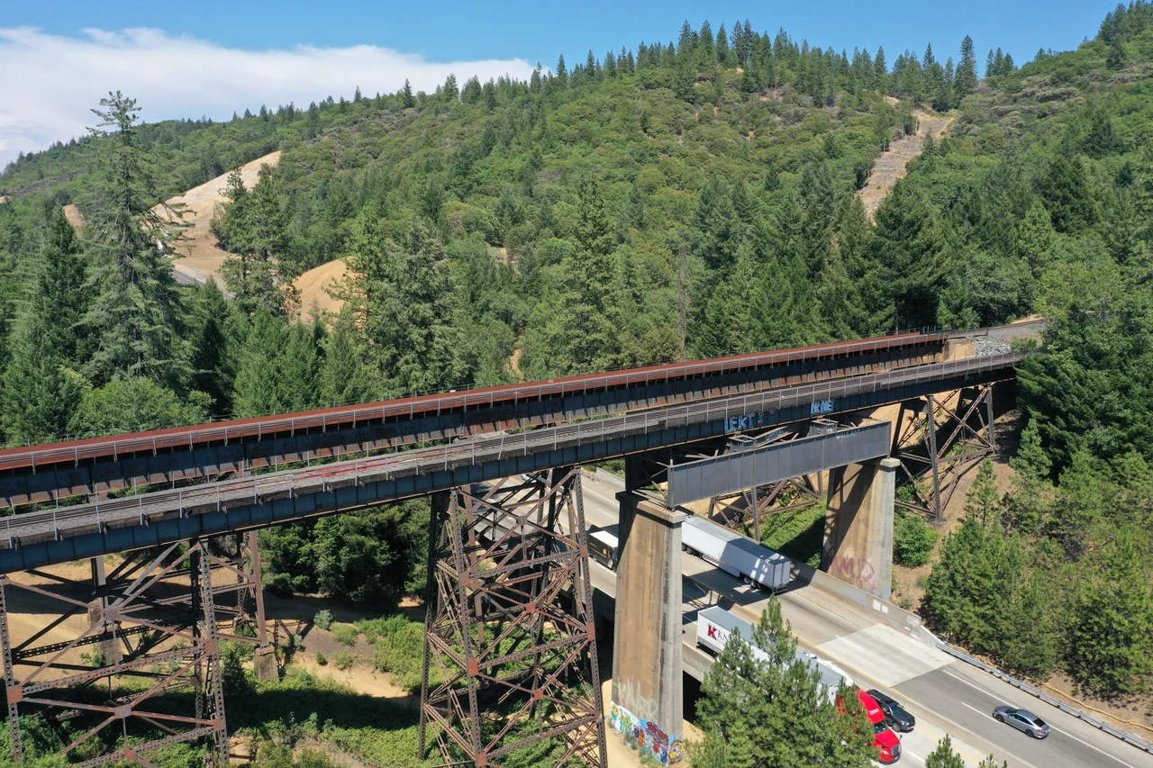
By 1890, the wooden Howe truss had served its purpose for a quarter century, and the railroad replaced it with an iron structure better suited to the heavier locomotives and longer trains of the era. The transition from wood to iron at Long Ravine mirrored a broader transformation across the western railroad network, where the improvised timber bridges of the construction era were systematically swapped out for engineered metal spans. Southern Pacific, which had absorbed the Central Pacific, then double-tracked the line through the Sierra Nevada to handle growing freight and passenger volumes. The two modern deck plate girder bridges that stand today were completed in 1912 and 1913, built to carry the weight of twentieth-century railroading across a ravine that nineteenth-century engineers had first spanned with timber.
Steel, Asphalt, and the Zephyr
Today, Interstate 80 runs through Long Ravine beneath the twin bridges, adding a third layer of transportation infrastructure to a site that has been continuously crossed since the 1860s. The bridges carry Union Pacific Railroad's Roseville Subdivision, predominantly serving freight trains hauling goods between the Pacific coast and the interior. But once each day, the Amtrak California Zephyr passes overhead on its 2,438-mile journey between Emeryville and Chicago, following the same corridor that the Central Pacific carved through the Sierra Nevada more than 150 years ago. From the bridge deck, the view stretches across the ravine to the pine-covered slopes of Placer County. From Interstate 80 below, drivers who look up see the dark silhouette of plate girders against the sky -- if they notice them at all.
From the Air
Long Ravine Trestle is located at 39.124N, 120.940W near Colfax, California, in the Sierra Nevada foothills. The twin bridges cross both Long Ravine and Interstate 80, making them visible as parallel steel structures spanning a gap in the terrain with highway traffic below. Follow the Union Pacific rail corridor east from Roseville; the bridges are just east of Colfax. Nearby airports include Auburn Municipal Airport (KAUN) approximately 14 miles southwest and Nevada County Airport (KGOO) approximately 15 miles north. Best viewing altitude is 2,000-3,000 feet AGL. The terrain is steep and wooded, with I-80 providing a visual reference.
Nearby Stories
- Sutter National Wildlife Refuge 10 km away
- The Lake That Swallowed a Gold Rush Town 13 km away
- Griffith Mansion 20 km away
- The Yuba County Five 34 km away
- Honey Run Covered Bridge 40 km away
- Western Pacific Railroad Museum 49 km away
- New Melones Dam 100 km away