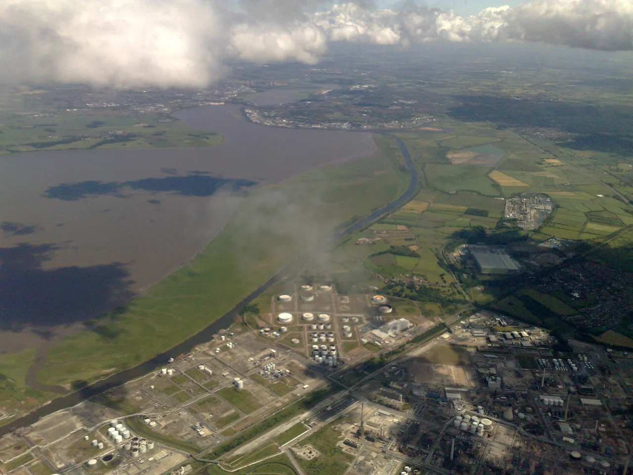

Manchester Ship Canal
In 1882 Manchester decided it would become a seaport. The decision had an obvious problem: Manchester was forty miles inland, and the docks of Liverpool stood between the city's factories and the Atlantic, charging fees that local manufacturers considered extortionate. The solution Manchester's businessmen settled on was extraordinary in scope. They would dig a canal large enough to bring ocean-going ships from the Mersey estuary directly into the centre of an industrial city. Construction took six years, cost just over £15 million, and consumed the labour of an average twelve thousand workers, peaking at seventeen thousand. When the Manchester Ship Canal opened in January 1894, it was the largest river navigation canal in the world. Queen Victoria came to open it formally in May. The Port of Liverpool, which had fought the project at every turn, suddenly found itself competing with a port forty miles upriver.
The Town That Wanted the Sea
The idea of running ocean ships into Manchester was first proposed in 1660 and revived in 1712 by the civil engineer Thomas Steers. The necessary act of Parliament for the Mersey and Irwell Navigation passed in 1721 and construction began in 1724. By 1734 small boats could make the journey, but the navigation served only minor traffic. By the 1880s it was, in the words of one observer, "hopelessly choked with silt and filth," closed to all but smaller boats for most of the working year. The Long Depression of the 1870s and the punishing fees charged by the Port of Liverpool combined to focus business minds. Cheaper to import goods from Hull on the opposite side of the country than from Liverpool down the road, ran the complaint. Daniel Adamson, a Manchester manufacturer with a manor house at Didsbury, called a meeting at his home on 27 June 1882. He invited representatives of Lancashire towns, businessmen, politicians, and two engineers: Hamilton Fulton and Edward Leader Williams. Williams' design, a dredged channel with retaining walls and a series of locks lifting incoming vessels up to Manchester, was selected to form the basis of a bill.
Three Bills and a Hard Fight
Parliament does not approve a vision of this scale without resistance. The first bill, presented late in 1882, was rejected in January 1883 for breaching Standing Orders. The committee responded with hundreds of petitions, including one from Manchester signed by nearly 200,000 people. The second bill was rejected in August 1884 after fierce opposition from Liverpool's docks and from witnesses who warned that a canal could cause the Mersey estuary to silt up. Williams revised his design to enter the estuary at Eastham and run the canal along the south shore as far as Runcorn before striking inland. The third bill passed Parliament on 2 May 1885 and received royal assent on 6 August. Raising the money was harder than passing the bill. The act required £8 million in share capital within two years. By May 1887 only £3 million had been subscribed. A debt restructuring split the capital into ordinary and preference shares, Barings and Rothschild jointly issued a prospectus, and the project finally broke ground on 11 November 1887 when Lord Egerton of Tatton cut the first sod. Daniel Adamson, who had wanted the money raised from ordinary working people rather than from the City of London, resigned in protest at the restructuring.
Six Years of Digging
Thomas Walker was appointed contractor with Williams as chief engineer. The thirty-six mile route was divided into eight sections, each under a different engineer. More than 54 million cubic yards of earth and rock were moved, about half the volume excavated for the Suez Canal. Two hundred miles of temporary railway track, 180 locomotives, more than 6,000 wagons, 124 steam cranes, 192 other steam engines, and 97 steam excavators were deployed. Regular navvies earned roughly six pence an hour for a ten-hour day, equivalent to about £16 per day in 2010 money. Walker died on 25 November 1889 and the work continued under his executors. Harsh winters and serious flooding repeatedly set back the schedule. The canal company exhausted its £8 million capital in four years with only half the work done, and was forced to appeal to Manchester Corporation, which lent first £3 million and then another £1.5 million in exchange for control of the company board. The city's rates rose 26 per cent between 1892 and 1895. The first sections opened to traffic in 1891 at Saltport, near the mouth of the Weaver Navigation, and the full canal was filled with water in November 1893. The Manchester Ship Canal Police were formed that December. Traffic began on 1 January 1894.
Barton, Trafford, and the Slow Decline
The canal's engineering achievements include the Barton Swing Aqueduct, still the world's only swing aqueduct, which carries the older Bridgewater Canal over the Ship Canal on a swinging steel trough. A neighbouring swing road bridge handles vehicle traffic, and both are now Grade II* listed. Two years after the canal opened, the financier Ernest Terah Hooley bought the 1,183-acre Trafford estate from Sir Humphrey de Trafford for £360,000 and began developing what became Trafford Park, the world's first planned industrial estate and for decades one of the largest in Europe. The Manchester Liners shipping company ran ocean-going vessels in and out of the docks at Salford from 1898 onward, and the new Port of Manchester became Britain's third busiest port despite being far inland. Traffic peaked in 1958 at 18 million long tons. Then containerisation arrived. Ships grew larger than the canal could accommodate. The Salford terminal docks closed in 1984 and the area was rebranded Salford Quays. Peel Holdings acquired the canal in 1993 and is pursuing a £50 billion Atlantic Gateway scheme to revive freight, with plans to push container traffic from 8,000 a year to 100,000 by 2030. The canal still moves crude oil to the Stanlow refinery at Eastham and a wide range of intra-European cargo. It remains the world's eighth-longest ship canal, only slightly shorter than the Panama, and the longest river navigation canal anywhere.
From the Air
Stretches roughly 36 miles from Eastham on the Mersey estuary (53.32°N, 2.96°W) to Manchester city centre (53.47°N, 2.30°W). The canal is best appreciated from the air because the scale of the cut only resolves at altitude. From 3,000–5,000 ft, the parallel relationship between the canal and the Mersey from Eastham to Runcorn is clearly visible, as is the Barton Swing Aqueduct (53.48°N, 2.36°W) carrying the Bridgewater Canal across the Ship Canal. The Trafford Park industrial estate sprawls south of the canal between Eccles and Manchester. Nearest airports: Manchester (EGCC) sits 4 nm south of the canal's terminus, Liverpool John Lennon (EGGP) is 3 nm north of the canal mouth at Eastham, Hawarden (EGNR) is 8 nm southwest of the canal entrance. Long shadows in late afternoon sun reveal the locks at Eastham, Latchford, Irlam, Barton, and Mode Wheel.
Nearby Stories
- Anson Engine Museum 1.3 km away
- West Kirby 2.9 km away
- Battle of Nantwich 6.2 km away
- Winter Hill Air Disaster 8.3 km away
- Horseshoe Pass 8.8 km away
- Caverswall Castle 12 km away
- Murder of Lindsay Rimer 15 km away
- Piel Castle 50 km away