Marrah Mountains
From the air, the Marrah Mountains look wrong. You are flying over the Sahel, everything below you brown and dry, savanna scrub running to horizon, and then a great green massif rears up out of the flatness and climbs to three thousand meters. At the top, a perfectly circular volcanic caldera holds two saline lakes, one larger and greener, one smaller and clearer, and the air is cool enough to grow citrus and stone fruit. This is the highest ground in Sudan, a piece of Mediterranean climate dropped into the middle of the African continent.
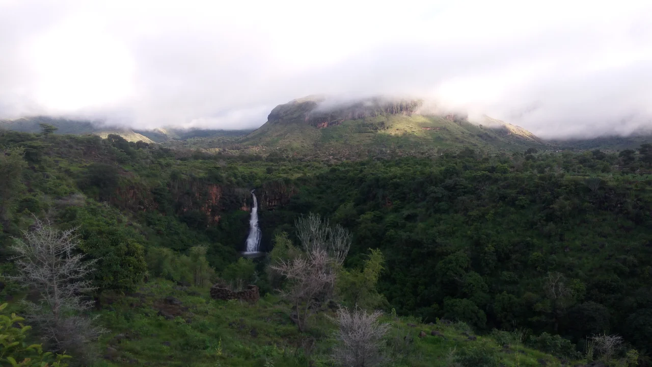
An Island of Rain
In the Fur language the range is Fugo Marra. In Arabic, Jebel Marra. It rises 2,600 meters above the plain and tops out at the rim of Deriba Caldera, 3,042 meters at peak. Apart from the Aïr Mountains in Niger, which stand at the edge of the Sahara proper, the Marrah Mountains are the only major range in the otherwise flat Sahel. What they catch, more than anything else, is rain. The uplift pulls moisture out of air that passes nowhere else. Springs run year-round. Terraced farms climb the slopes. Acacia and olive give way, higher up, to juniper forest. The surrounding Sahel turns gold and then tan and finally dun-brown as the dry season progresses. The mountains stay green.
Deriba's Two Lakes
At the top, the volcanic caldera collapsed around 1500 BC after an eruption that sent pyroclastic flows more than thirty kilometers. What it left behind is an amphitheater roughly five kilometers across, steep-walled, with two lakes at its bottom. Locals call the larger one the female lake: about 1,780 meters long, salty, green, with an unpleasant odor. The smaller male lake, 800 meters to the south, has fresher water, crater walls that rise almost vertical from its edge, and a strange funnel-shaped profile that has puzzled every expedition since the first bathymetric survey in 1964. The lakes' water levels have shifted abruptly over the centuries, evidenced by old beach terraces, probably after landslides off the unstable inner walls. Standing on the rim at dawn, you are looking down at something that is simultaneously ancient and restless.
Who Lives Here
The Fur people have farmed these slopes and terraces for centuries, long enough that the mountains appear in every Fur origin story. Their terraced agriculture, barley and wheat and fruit orchards, adapts to the cool temperate climate in a way that would be impossible on the Sahel below. Villages cluster at springs and along permanent streams. Water, which defines everything in this region, is present here year-round. The Fur kingdom, which ruled much of what is now Darfur from the seventeenth century until the British conquest, drew on the Marrah Mountains as homeland and refuge. In the conflicts of the past two decades, the mountains have remained a refuge: the Sudan Liberation Movement/Army faction loyal to Abdul Wahid al Nur has controlled the range since the War in Darfur began, and continues to hold it as of 2025, through the current Sudanese civil war.
The Landslide at Tarasin
On August 31, 2025, after days of heavy rainfall, a landslide buried the village of Tarasin on the Marrah slopes. More than a thousand people died. Entire families were lost. The rebel group that controls the area announced the disaster before any international media arrived. Rescue was nearly impossible. The ground the village sat on had saturated, slid, and then set around the crushed houses like concrete. What happened at Tarasin was the largest landslide disaster of the 2020s in Africa, and it happened in a region already cut off from aid by war. The villagers who died at Tarasin were, overwhelmingly, Fur farmers who had been displaced once already by the Darfur genocide and had rebuilt their lives on these terraces because no other place felt safe. The mountains had protected them, until a wet August proved that no mountain can protect anyone forever.
What the Range Remembers
Archaean rocks underlie everything here, some of the oldest bedrock on the continent. The volcanic activity that built the visible range began in the Miocene and ended just 3,500 years ago. The Tagabo Hills to the northeast and the Meidob Plateau further north are the range's geological companions, all part of a single uplift between the Chad and Middle Nile basins. Geologists keep returning when they can. Botanists have cataloged endemic plant species that grow nowhere else. Isolated near the geographic center of Africa, the Deriba lakes hold chemical signatures that tell stories about climate change and weathering going back millennia. But for the people who live on Jebel Marra's slopes now, the mountains are what they have always been: home, refuge, a place where the rain still falls when it no longer falls anywhere else, and a place where the ground sometimes gives way.
From the Air
The Marrah Mountains are centered at approximately 12.95°N, 24.27°E in central Darfur, Sudan. Peak elevation at Deriba Caldera: 3,042 meters (9,980 feet). The massif extends roughly 160 km north-south and 65 km east-west. Recommended viewing altitude: 15,000-20,000 feet for a full view of the range's rise above the surrounding Sahel. Be aware of significant terrain - plan for minimum safe altitudes well above 3,500 meters (11,500 feet). Nearest airports are Nyala (HSNN) to the southeast and Al-Fashir (HSFS) to the northeast, though operational status varies during the ongoing conflict. Cloud formation is common over the summit due to orographic lift, particularly during the July-September rainy season.
Nearby Stories
- Conquest of Darfur (1873–1874) 9.9 km away
- Zamzam and Abu Shouk refugee camp massacres 51 km away
- West Darfur 79 km away
- Zamzam Refugee Camp 101 km away
- Kreinik massacre 113 km away
- 1987 Dhein massacre 184 km away
- Central African Republic–Chad border 222 km away
- Central African Republic–Sudan border 256 km away