The Base That Became a Business Park
Major Hezekiah McClellan was born in 1894 and spent his career pushing the boundaries of what aircraft could endure. He pioneered arctic aeronautical testing, flying in conditions that killed engines and froze instruments, proving that military aviation could operate in the world's coldest latitudes. On May 25, 1936, his Consolidated P-30 crashed during a flight test near Centerville, Ohio, and the man who had survived the Arctic did not survive a routine evaluation flight. Three years later, the Sacramento Air Depot was renamed in his honor. The irony would have been lost on no one: McClellan Field was a logistics and maintenance base, the place where other people's aircraft were repaired, overhauled, and sent back into service. It fixed what the flying broke.
The Machine Behind the Machine
McClellan was never a glamorous assignment. Established in 1935 as the Pacific Air Depot, it existed to keep the Air Force's equipment running -- a sprawling industrial campus of maintenance hangars, supply warehouses, and repair shops northeast of Sacramento. While fighter bases produced aces and bomber bases produced strategic deterrence, McClellan produced something less romantic and more essential: readiness. Over its lifetime the base cycled through a parade of command assignments that reads like a bureaucratic history of American air power itself: Material Division, Air Service Command, Air Technical Service Command, Air Materiel Command, Air Force Logistics Command, and finally Air Force Materiel Command. Each name change reflected reorganization at the Pentagon, but the work on the ground remained the same -- tear down aircraft, find what was wrong, fix it, send it back.
Coast Guard and Cold War
McClellan's maintenance mission attracted tenants. The United States Coast Guard operated Coast Guard Air Station Sacramento on the base, flying and maintaining several HC-130 Hercules search-and-rescue aircraft. The Coast Guard presence outlasted the Air Force itself -- CGAS Sacramento continued operating at McClellan after the base closed in 2001 and remains the only military aviation unit on the airfield today. In 1986, the Air Force established the McClellan Aviation Museum on base, later chartered by the National Museum of the United States Air Force. The museum collected aircraft from McClellan's own history and from neighboring installations like Beale AFB, Travis AFB, and the since-closed Mather AFB. In 2005, it was renamed the Aerospace Museum of California, and today it displays military aircraft inside a hangar and across the former flightline, offering school programs that teach Sacramento children the history that unfolded on the tarmac beneath their feet.
Politics and the Closure List
In 1993, the Pentagon selected McClellan for closure. The decision was not clean. McClellan was initially scratched from the base closure list, but that reprieve drew allegations that the Clinton administration was playing politics with California's military infrastructure. The base was put back on the list and eventually scheduled for shutdown. The projected economic damage was staggering: $1.5 billion in lost economic activity and 11,000 jobs eliminated from the Sacramento region. The plan to absorb the blow relied on privatization and commercial investment -- converting hangars and warehouses into office space, trading uniforms for business casual. The Air Force Reserve's 604th Regional Support Group relocated to March Air Reserve Base in 1997 as part of the BRAC reshuffling, and McClellan Air Force Base officially closed on July 13, 2001, ending sixty-six years of continuous military operations.
Reinvention at Eight Million Square Feet
What replaced the base was McClellan Business Park, which now hosts hundreds of private companies alongside state, federal, and local government agencies across more than eight million square feet of commercial space. The conversion was deliberate and aggressive: rather than let the property decay behind chain-link fencing, Sacramento County and its partners marketed the infrastructure -- the runways, the hangars, the warehouse space -- as ready-made assets for businesses that needed room to operate. AmeriCorps NCCC Pacific Region established its headquarters on the former base. The transformation from military installation to commercial campus happened faster and more completely than many BRAC conversions, driven in part by Sacramento's booming economy and the sheer quality of the infrastructure the Air Force left behind.
What the Water Remembers
Beneath the business park, a less hopeful story persists. In 2015, the Sacramento Bee reported that McClellan Airfield had been designated a Superfund site after the Environmental Protection Agency identified 326 waste areas on the former base. Sixty-six years of industrial military operations -- solvents, fuels, degreasers, and the chemical byproducts of maintaining a fleet of aircraft through hot wars and cold ones -- had seeped into the ground. Water wells in the neighboring Rio Linda-Elverta district showed the highest levels of hexavalent chromium, a known carcinogen. Six of eleven wells tested above California's maximum contaminant level of ten parts per billion. The McClellan Restoration Advisory Board now provides a forum for residents, regulators, and the Air Force to coordinate cleanup, a process measured in decades rather than years. The base that spent its life fixing what flying broke now confronts the things it broke itself.
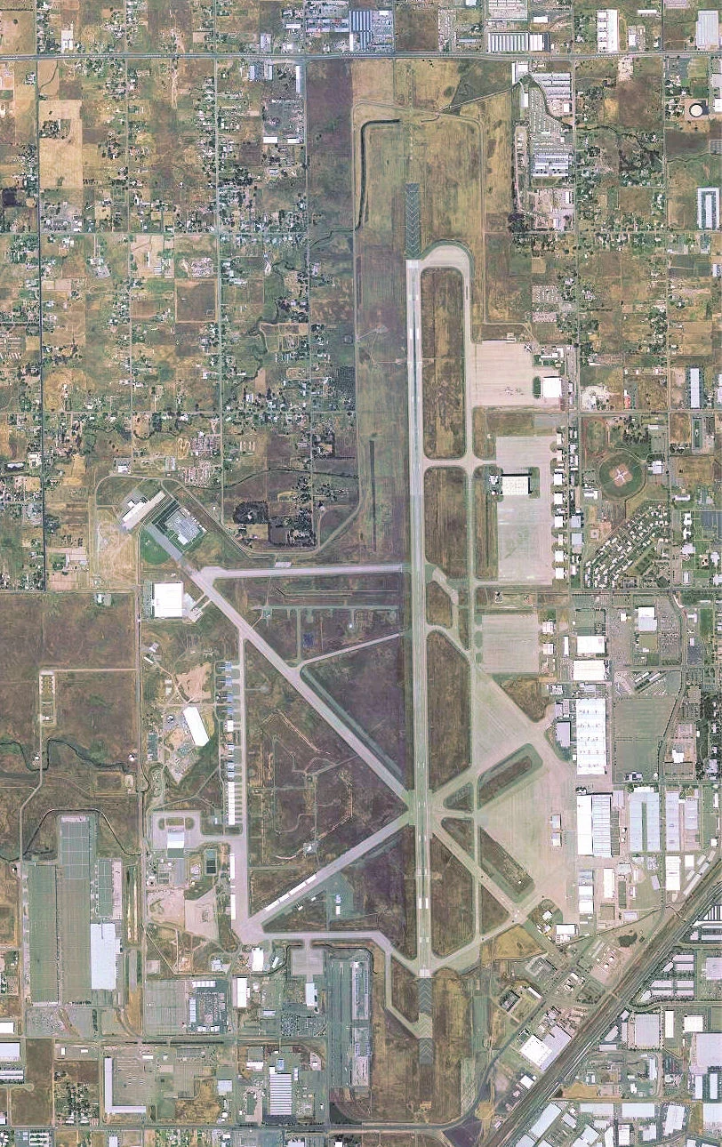
From the Air
Located at 38.668N, 121.401W in the North Highlands area, 7 miles northeast of downtown Sacramento. The former military runway remains visible as McClellan Airfield. Sacramento Executive Airport (KSAC) is approximately 8nm south-southwest; Sacramento International (KSMF) is 12nm west-northwest. Mather Airport (KMHR) lies 10nm south-southeast. The sprawling former base footprint, with its distinctive grid of taxiways and large hangars, is clearly identifiable from 3,000-5,000 feet AGL against the flat Sacramento Valley floor.
Nearby Stories
- Cosumnes River Preserve: The Last Free-Flowing River 6.5 km away
- The Warehouse on Oakdale Road 10 km away
- The Stone Chapel That Survived Everything 14 km away
- Four Names, Three Wars, Nine Missiles 18 km away
- Gold Country 24 km away
- Rico Harris 29 km away
- New Melones Dam 55 km away
- Malakoff Diggins State Historic Park 57 km away