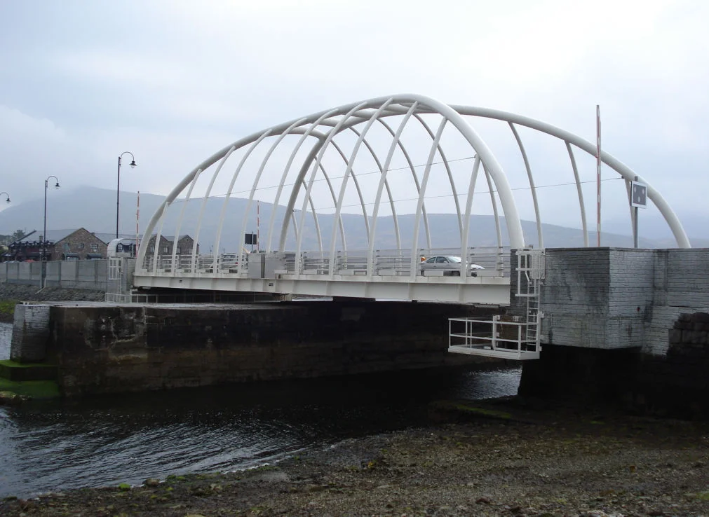

Michael Davitt Bridge
Most bridges promise permanence. The Michael Davitt Bridge promises to move. Once or twice a day, a single operator turns a key, traffic stops on the R319, and 390 tonnes of steel and concrete swing open across Achill Sound to let a sailboat pass. Then it closes again, and Achill Island - the largest island off the Irish coast - is reconnected to the Corraun Peninsula and the County Mayo mainland. The bridge that lets the island be an island is named for a man who spent his life arguing that Irish tenants should not be cast off the land beneath their feet.
A Fenian's Bridge
Michael Davitt was a strange choice for a bridge namesake by Victorian standards. He had lost an arm in a Lancashire cotton mill at age eleven, served seven years in English prisons as a Fenian, and founded the Irish National Land League in 1879 to challenge the very landlords who usually got buildings named after them. But in Mayo - Davitt's home county and the cradle of the Land League - he was already a hero by 1887. So when a Fermanagh philanthropist named John Grey Vesey Porter dug into his own pocket to cover the cost overruns on a new bridge to Achill, the Mayo County Surveyor's office knew exactly whose name to chisel on it. Davitt himself, then a Member of Parliament, came to open it. The original span was a steel bowstring girder, 120 feet long and just 8 feet wide - enough for the horse carts of a 19th-century island, not much more.
Three Bridges, One Crossing
The 1887 bridge served Achill for 60 years before motor traffic finally ground it down. In 1947 the Mayo County Council commissioned J & C McGloughlin of Dublin to replace it, and the result - completed in 1949 - was at the time the largest bridge project ever undertaken by an Irish firm. That second bridge in turn lasted until 2007, when corrosion and a balky swing mechanism convinced the council to start over. The current bridge, designed by Malachy Walsh & Partners on a model inspired by the Spanish architect Santiago Calatrava, opened in 2008. Its 390 tonnes are still rotated by hand. For a few hours in November 2010 the new mechanism stuck open, snarling traffic for over two hours and reminding everyone that the simplest moving parts can have the most public consequences.
Island, Peninsula, Island Again
There is something quietly philosophical about a swing bridge. Achill is by every meaningful measure an island - 148 square kilometres of bog, cliff, and Atlantic shoreline - but for most of the day it is functionally a peninsula, joined to Corraun by an asphalt seam. When the bridge opens, the connection dissolves; a yacht slips through; the connection returns. Locals barely notice. Visitors stop their cars and lean on the rails to watch the sound move beneath them. Below, the tide funnels through one of the narrower channels on the Wild Atlantic Way, fast and cold and brown with peat from the bogs upstream. The bridge celebrated its 130th anniversary on 3 September 2017, counting all three generations as a single continuous crossing.
Standing Where Davitt Stood
The west end of the bridge lands on Achill Island; the east end on the mainland at Achill Sound village. On either approach, the granite hills of the Corraun Peninsula and the long quartzite ridge of Slievemore frame the view. The current span - white-painted, cable-stayed, modern - looks nothing like the 1887 original, but the alignment is essentially the same. Drive across slowly. The cars behind you will understand. Everyone slows on this bridge.
From the Air
53.93N, 9.92W. The Michael Davitt Bridge is the only road crossing between Achill Island and the County Mayo mainland, visible as a slim white span across Achill Sound. From the air it stands out against the dark tidal channel separating the Corraun Peninsula from Achill. Best viewed at 1,500-3,000 ft. Ireland West Airport Knock (EIKN) lies about 70 km east-southeast; Sligo Airport (EISG) is roughly 90 km northeast. Atlantic weather on this coast is volatile - expect rapid changes in cloud cover and crosswinds from the southwest.
Nearby Stories
- Tully Cross 4.6 km away
- Binghamstown 6.7 km away
- Lough Mask Murders 6.8 km away
- Aughagower 13 km away
- Ballycastle, County Mayo 18 km away
- Action of 7 May 1794 36 km away
- RMS Carinthia (1925) 45 km away
- Inishtooskert 194 km away